Related Research Articles
Babson Ledge is a small barren rock within the edge of the Western Harbor and Gloucester Harbor in Gloucester, Massachusetts. The rock is situated south of the Fort Point, Pavilion Beach, Blynman Canal, Route 127, and west of Rocky Neck.
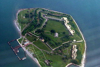
Georges Island is one of the islands in the Boston Harbor, situated just over 7 miles (11 km) from downtown Boston. The island has a permanent size of 39 acres (160,000 m2), plus an intertidal zone of a further 14 acres (57,000 m2), and rises to a height of 50 feet (15 m) above sea level. Historic Fort Warren is on the island. Because of this, and since a ferry operates from Boston to the island, it is a popular destination and one of the easiest islands to access in the Boston Harbor Islands National Recreation Area.
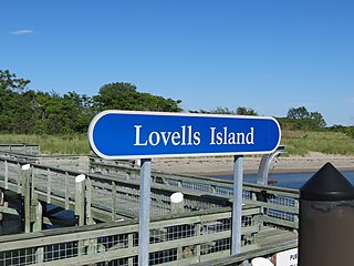
Lovells Island, or Lovell's Island, is a 62-acre (250,000 m2) island in the Boston Harbor Islands National Recreation Area, in Massachusetts. The island is across The Narrows from Georges Island and some 7 miles (11 km) offshore of downtown Boston. It is named after Captain William Lovell, who was an early settler of nearby Dorchester. The island is known as the site of several shipwrecks, including the 74-gun French warship Magnifique in 1782.

Great Brewster Island is one of the outer islands in the Boston Harbor Islands National Recreation Area, situated some 9 miles (14 km) offshore of downtown Boston. The island has a permanent size of 18 acres (73,000 m2), plus an intertidal zone of a further 49 acres (200,000 m2). Unlike the other outer islands, which are low-lying outcroppings of bedrock, Great Brewster is a drumlin which reaches a height of over 100 feet above sea level. It has vegetation cover consisting of Apple Trees, Pear Trees, Sumac, Beach Roses, Grasses and Common Reeds, together with a large Gull colony. The birds are aggressive during nesting season and access by humans, which is by private boat only, is discouraged during that time.

Tinkers Island is a pair of small islands off the coast of Marblehead, Massachusetts, United States. It is only accessible by boat and houses several small camps. The island was named after the breed of mackerel that can be found close to its shores.

Spinnaker Island is an island in the Hingham Bay area of Boston Harbor in Massachusetts, USA. The island is part of the town of Hull, to which it is connected by a bridge, and is one of the few harbor islands that neither forms part of the Boston Harbor Islands National Recreation Area nor is considered within the municipal limits of the city of Boston.

Crowninshield Island, also known as Brown's Island, is a small island off the shore of Marblehead, Massachusetts. Since 1955, it has been maintained by The Trustees of Reservations. For all Trustees of Reservations purposes, the island is referred to as Crowninshield Island, however federally the island is still maintained as "Brown's Island", and it remains better known by that name locally.

The Ipswich River Wildlife Sanctuary, which is the Massachusetts Audubon Society’s largest wildlife sanctuary, is located in Topsfield and Wenham, Massachusetts. Much of its 2,800-acre (11 km2) landscape was created by a glacier 15,000 years ago.

Gurnet Point, also known as The Gurnet, is located at the end of the peninsula at the entrance to Plymouth Bay in Plymouth, Massachusetts, and is a headland and the small private settlement located on it. The Pilgrims who settled Plymouth in 1620 named it Gurnett's Nose for its resemblance to headlands in the English Channel where gurnett fish were plentiful. The Gurnet is the home of Plymouth (Gurnet) Lighthouse as well as Fort Andrew from the Revolutionary War and Civil War. Its access by land is either from Gurnet Road in Marshfield or from the Powder Point Bridge at Duxbury Beach 5 miles to the north by foot or by 4-wheel drive beach buggies, but access is restricted to property owners, residents and their guests, except for once a year on Memorial Day when the lighthouse is open to the public.

The Misery Islands are an 87-acre (350,000 m2) nature reserve established in 1935 in Salem Sound close to the Salem Harbor in Salem, Massachusetts. It is managed by the Trustees of Reservations. The islands are a part of the city of Salem, although they are much closer to the city of Beverly, in whose aquatic territory they lie.

Fort Andrews was created in 1897 as part of the Coast Defenses of Boston, Massachusetts. Construction began in 1898 and the fort was substantially complete by 1904. The fort was named after Major General George Leonard Andrews, an engineer and Civil War commander, who assisted in the construction of nearby Fort Warren in Boston Harbor. It occupies the entire northeast end of Peddocks Island in Boston Harbor, and was originally called the Peddocks Island Military Reservation. Once an active Coast Artillery post, it was manned by hundreds of soldiers and bristled with mortars and guns that controlled the southern approaches to Boston and Quincy Bay. The fort also served as a prisoner-of-war camp for Italian prisoners during World War II, who were employed as laborers following the Italian surrender to the Allies in 1943. Today, the fort is abandoned, and is managed by the Massachusetts Department of Conservation and Recreation, as part of the Boston Harbor Islands National Recreation Area.

Fort Heath was a US seacoast military installation for defense of the Boston and Winthrop Harbors with an early 20th-century Coast Artillery fort, a 1930s USCG radio station, prewar naval research facilities, World War II batteries, and a Cold War radar station. The fort was part of the Harbor Defenses of Boston and was garrisoned by the United States Army Coast Artillery Corps. The fort's military structures have been replaced by a residential complex, including the luxurious Forth Heath Apartments, and recreation facilities of Small Park, which has both a commemorative wall and an historical marker for Fort Heath.
Camp Hobson was a military camp that existed during the Spanish–American War in 1898 in Gloucester, Massachusetts. It was located near the works known as Stage Fort, Fort Banks, Fort Cross, Fort Allen, and Fort Conant during their intermittent use. The fort was restored in 1930; it and the Camp Hobson site are now located in Stage Fort Park.

Camp Lander is a former Massachusetts militia camp active during 1862 and located in Wenham, Massachusetts. The site is now the occupied by Pingree Park.
Camp Edmunds is a former Massachusetts State Militia camp that existed in 1856 in Salem, Massachusetts, near Fort Pickering on Winter Island.
Camp Banks is a former Massachusetts State Militia camp that existed in 1858 in Salem, Massachusetts, near Fort Pickering on Winter Island.
Camp Guild is a former World War I mobilization camp that existed in 1917 in Boxford, Massachusetts.
Camp Edwin M. Stanton was an American Civil War training camp that existed from 1861-1862 in Lynnfield, Massachusetts. When the camp first opened in 1861, it was known as Camp Schouler, named for Massachusetts Adjutant General William Schouler. After President Abraham Lincoln's call for 300,000 troops in July 1862, the camp was revived and renamed in honor of United States Secretary of War Edwin M. Stanton. It served as the training camp and rendezvous for recruits from Eastern Massachusetts. Soldiers stationed at Camp Schouler/Stanton during training included Edward A. Wild, Henry Wilson, Nelson A. Miles, Edward Winslow Hinks, and Arthur F. Devereux. During World War I it was renamed Camp Houston and served as a Massachusetts National Guard mobilization camp in 1917. It was located on the Newburyport Turnpike near the Peabody, Massachusetts line. The camp was divided into streets, with tents and cook houses located on both sides of the Turnpike to Suntaug Lake.
Ipswich Camp was a former infantry and field artillery coastal defense base camp that existed from between May 1942 and November 1943 in Ipswich, Massachusetts, USA. Company L of the 181st Infantry Regiment was stationed at the camp, alongside Battery B of the 211th Field Artillery Battalion. The infantry company patrolled between Newburyport and Lynn, while the field artillery battery was located along several earthwork positions along the coast.

Namur River 174A is an Indian reserve of the Fort McKay First Nation in Alberta, located within the Regional Municipality of Wood Buffalo. It is 65 kilometres northwest of Fort McMurray.
References
- ↑ "Massachusetts". American Forts Network. Retrieved 9 September 2013.