Campbellsburg, Kentucky

Last updated

Campbellsburg, Kentucky
Henry County Kentucky Incorporated and Unincorporated areas Campbellsburg Highlighted 2112142.svg
Location of Campbellsburg in Henry County, Kentucky.
Coordinates: 38°31′19″N85°13′10″W / 38.52194°N 85.21944°W / 38.52194; -85.21944
Country United States
State Kentucky
County Henry
Government
  MayorDavid Gray
Area
[1]
  Total1.35 sq mi (3.49 km2)
  Land1.32 sq mi (3.43 km2)
  Water0.03 sq mi (0.06 km2)
Elevation
[2]
889 ft (271 m)
Population
 (2020) [3]
  Total836
  Density631.90/sq mi (243.96/km2)
Time zone UTC-5 (Eastern (EST))
  Summer (DST) UTC-4 (EDT)
ZIP code
40011
Area code 502
FIPS code 21-12142
GNIS feature ID2403982 [2]
Website www.cityofcampbellsburg.org

Campbellsburg is a home rule-class city in Henry County, Kentucky, in the United States. The population was 836 at the 2020 census. It is home to Post 5 of the Kentucky State Police.[ citation needed ]

Contents

History

The city was incorporated by the state legislature in 1840 as "Chiltonsville", [4] in honor of its trustee Charles J. Chilton, but the name was changed within three weeks to "Campbellsburg" for another local family. Later the same year, the local post office at Benevola was renamed "Campbellsburg" as well. The arrival of the Louisville, Cincinnati and Lexington Railroad in 1869 led to a division of the town into "Old" and "New Campbellsburg". The later was separately incorporated in 1876 but eventually expanded until the two polities merged into the present town. [5]

Campbellsburg's central business district was rebuilt after much of it was destroyed by a tornado on April 1, 1974.[ citation needed ]

Geography

Campbellsburg is located in northwestern Henry County. U.S. Route 421 is the city's Main Street; it leads west 1.8 miles (2.9 km) to Interstate 71 at Exit 34 and northwest 9 miles (14 km) to Bedford, while to the southeast US-421 leads 37 miles (60 km) to Frankfort, the state capital. I-71 leads northeast 63 miles (101 km) to Cincinnati and southwest 35 miles (56 km) to Louisville.

According to the United States Census Bureau, Campbellsburg has a total area of 1.6 square miles (4.1 km2), of which 0.04 square miles (0.1 km2), or 2.45%, is water. [6]

Demographics

Historical population
CensusPop.Note
1880 107
1890 342219.6%
1900 191−44.2%
1910 26940.8%
1940 350
1950 3613.1%
1960 348−3.6%
1970 47937.6%
1980 71449.1%
1990 604−15.4%
2000 70516.7%
2010 81315.3%
2020 8362.8%
U.S. Decennial Census [7]

As of the census [8] of 2000, there were 705 people, 283 households, and 202 families residing in the city. The population density was 1,246.3 inhabitants per square mile (481.2/km2). There were 298 housing units at an average density of 526.8 per square mile (203.4/km2). The racial makeup of the city was 94.75% White, 3.83% African American, 0.85% Asian, 0.43% from other races, and 0.14% from two or more races. Hispanic or Latino of any race were 1.28% of the population.

There were 283 households, out of which 32.2% had children under the age of 18 living with them, 51.6% were married couples living together, 18.7% had a female householder with no husband present, and 28.6% were non-families. 26.9% of all households were made up of individuals, and 15.9% had someone living alone who was 65 years of age or older. The average household size was 2.49 and the average family size was 3.01.

In the city, the population was spread out, with 27.4% under the age of 18, 7.9% from 18 to 24, 25.5% from 25 to 44, 23.3% from 45 to 64, and 15.9% who were 65 years of age or older. The median age was 36 years. For every 100 females, there were 84.6 males. For every 100 females age 18 and over, there were 77.2 males.

The median income for a household in the city was $35,865, and the median income for a family was $41,406. Males had a median income of $31,250 versus $21,250 for females. The per capita income for the city was $15,755. About 10.5% of families and 18.1% of the population were below the poverty line, including 22.6% of those under age 18 and 19.5% of those age 65 or over.

Notable people

Related Research Articles

<span class="mw-page-title-main">New Castle, Kentucky</span> City in Kentucky, United States

New Castle is a home rule-class city in Henry County, Kentucky, United States. It is the seat of its county. As of the 2010 census the population was 912. African Americans attended New Castle Colored School prior to integration.

<span class="mw-page-title-main">Bancroft, Kentucky</span> City in Kentucky, United States

Bancroft is a home rule-class city in Jefferson County, Kentucky, United States. It was formally incorporated by the state assembly in 1970. The population was 503 as of the 2020 census, up from 494 at the 2010 census.

<span class="mw-page-title-main">Beechwood Village, Kentucky</span> City in Kentucky, United States

Beechwood Village is a home rule-class city in Jefferson County, Kentucky, United States. The city was formally incorporated by the state assembly in 1950. The population was 1,280 as of the 2020 census, down from 1,324 at the 2010 census

<span class="mw-page-title-main">Douglass Hills, Kentucky</span> City in Kentucky, United States

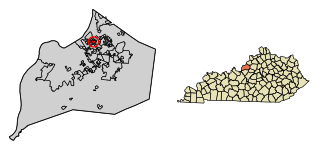
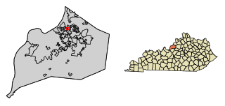
Douglass Hills is a home rule-class city in eastern Jefferson County, Kentucky, United States. The population was 5,484 at the 2010 census, down from 5,718 at the 2000 census.

<span class="mw-page-title-main">Druid Hills, Kentucky</span> City in Kentucky, United States

Druid Hills is a home rule-class city in Jefferson County, Kentucky, United States. The population was 308 at the 2010 census. It was incorporated in 1950.

<span class="mw-page-title-main">Fincastle, Kentucky</span> City in Kentucky, United States

Fincastle is a home rule-class city in eastern Jefferson County, Kentucky, United States. The population was 817 at the 2010 census.

<span class="mw-page-title-main">Glenview Manor, Kentucky</span> City in Kentucky, United States

Glenview Manor is a home rule-class city in Jefferson County, Kentucky, United States. The population was 191 at the 2010 census.

<span class="mw-page-title-main">Houston Acres, Kentucky</span> City in Kentucky, United States

Houston Acres is a home rule-class city in Jefferson County, Kentucky, United States. The population was 507 at the 2010 census.

<span class="mw-page-title-main">Meadowbrook Farm, Kentucky</span> City in Kentucky, United States

Meadowbrook Farm is a neighborhood of Louisville, Kentucky, United States. It is separately incorporated as a home rule-class city. The population was 136 as of the 2010 census.

<span class="mw-page-title-main">Meadowview Estates, Kentucky</span> City in Kentucky, United States

Meadowview Estates is a home rule-class city in Jefferson County, Kentucky, United States. The population was 178 at the 2020 census,.

<span class="mw-page-title-main">Moorland, Kentucky</span> City in Kentucky, United States

Moorland is a home rule-class city in Jefferson County, Kentucky, United States. The population was 431 as of the 2010 census.

<span class="mw-page-title-main">Northfield, Kentucky</span> City in Kentucky, United States

Northfield is a home rule-class city in Jefferson County, Kentucky, United States. The population was 1,020 at the 2010 census.

<span class="mw-page-title-main">Thornhill, Kentucky</span> City in Kentucky, United States

Thornhill is a home rule-class city in Jefferson County, Kentucky, United States. The population was 178 at the 2010 census.

<span class="mw-page-title-main">Watterson Park, Kentucky</span> City in Kentucky, United States

Watterson Park is a home rule-class city in Jefferson County, Kentucky, United States. The population was 976 at the 2010 census.

<span class="mw-page-title-main">Wildwood, Kentucky</span> City in Kentucky, United States

Wildwood is a home rule-class city in Jefferson County, Kentucky, United States. The population was 261 at the 2010 census.

<span class="mw-page-title-main">Hyden, Kentucky</span> City in Kentucky, United States

Hyden is a home rule-class city in and the county seat of Leslie County, Kentucky, United States. The population was 365 at the 2010 census. It is located at the junction of U.S. Route 421 and Kentucky Route 80, along the Middle Fork of the Kentucky River.

<span class="mw-page-title-main">Concord, Kentucky</span> City in Kentucky, United States

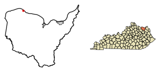
Concord is a home rule-class city in Lewis County, Kentucky, in the United States. The population was 35 at the 2010 census. It is part of the Maysville Micropolitan Statistical Area.

<span class="mw-page-title-main">Island, Kentucky</span> City in Kentucky, United States

Island is a home rule-class city in McLean County, Kentucky, in the United States. The population was 429 at the 2020 census. It is included in the Owensboro metropolitan area.

<span class="mw-page-title-main">Williamstown, Kentucky</span> City in Kentucky, United States

Williamstown is a home-rule-class city in Grant and Pendleton counties in the U.S. state of Kentucky. The population was 3,925 at the 2010 census, up from 3,227 as of the 2000 census. It is the county seat of Grant County.

<span class="mw-page-title-main">Pleasureville, Kentucky</span> City in Kentucky, United States

Pleasureville is a home rule-class city in Henry and Shelby counties, Kentucky, United States. The population was 834 at the time of the 2010 U.S. Census.

References

  1. "2020 U.S. Gazetteer Files". United States Census Bureau. Retrieved March 18, 2022.
  2. 1 2 U.S. Geological Survey Geographic Names Information System: Campbellsburg, Kentucky
  3. "Campbellsburg city, Kentucky - Census Bureau Profile". United States Census Bureau. Retrieved May 1, 2024.
  4. Collins, Lewis (1877). History of Kentucky. pp. 338–339.
  5. Rennick, Robert M. Kentucky Place Names . The University Press of Kentucky (Lexington), 1988. ISBN   0-8131-0179-4.
  6. "Geographic Identifiers: 2010 Demographic Profile Data (G001): Campbellsburg city, Kentucky". American Factfinder. U.S. Census Bureau. Retrieved July 5, 2017.[ dead link ]
  7. "Census of Population and Housing". Census.gov. Retrieved June 4, 2015.
  8. "U.S. Census website". United States Census Bureau . Retrieved January 31, 2008.