Katy is a city in the U.S. state of Texas. It is in the Greater Katy area, itself forming the western part of the Greater Houston metropolitan area. Homes and businesses may have Katy postal addresses without being in the City of Katy. The city of Katy is approximately centered at the tripoint of Harris, Fort Bend, and Waller counties. Katy had a population of 21,894 at the 2020 U.S. census, up from 14,102 in 2010.
The Memorial area of Houston, Texas is located west of Downtown, northwest of Uptown, and south of Spring Branch. The Memorial Super Neighborhood, as defined by the City of Houston, is bounded by Buffalo Bayou to the south, Barker Reservoir to the west, Westview to the north, and the Memorial Villages, a contiguous group of independent municipalities, to the east.

Trinity Church, in Midtown Houston, Texas, is a parish church in the Episcopal Diocese of Texas.
Westchase is a business district and neighborhood in western Houston, Texas, bounded by Westheimer Road on the north, Gessner Road on the east, Houston Center Boulevard on the west, and Westpark Tollway on the south. The area is bisected by Beltway 8. Westchase is adjacent to Greater Sharpstown, the International District, and the Royal Oaks Country Club subdivision. The area is immediately northeast of Alief.

Rice Military is a neighborhood in Houston, Texas, United States. The Beer Can House is located in Rice Military.
Bridgeland Community is an 11,401-acre (46.14 km2) master-planned community under construction in unincorporated Harris County, Texas, United States, to the northwest of Houston between U.S. Route 290 and Interstate 10. Bisecting Bridgeland is Segment E of the Grand Parkway, a 15.2-mile thoroughfare for which construction broke ground in 2011 and opened in December 2013.
Briargrove Park (BGP) is a subdivision in western Houston, Texas, United States. It has about 1,480 houses. It is bounded by Beltway 8, the Buffalo Bayou, Gessner Road, and Westheimer Road.

The Energy Corridor is a business district in Houston, Texas, located on the west side of the metropolitan area between Beltway 8 and the Grand Parkway. The district straddles a 7-mile (11 km) stretch of Interstate 10 from Kirkwood Road westward to Barker Cypress Road and extends south along Eldridge Parkway to Briar Forest Drive. Parts of the district overlap with the Memorial area of Houston. The district is located north of Westchase, another major business district of Houston, and east of Greater Katy.
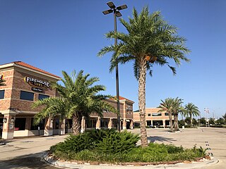
Greater Katy Area is the term often used to refer to a suburban region on the west side of the Greater Houston metropolitan area roughly corresponding to the boundaries of the Katy Independent School District. Many people and businesses in this area have a Katy address, but are not part of the city of Katy. This area includes the suburbs that surround the Katy city limits west to Pederson road, roughly east to State Highway 6, north to FM 529, and south to FM 1093/ Westpark Tollway Parkway. While these boundaries are not exact, it gives a rough outline of what most people consider Greater Katy, and what the USPS designates as "Katy, Texas" by assigning that city to addresses within zip codes that fall in this region. Most of Greater Katy is to the east of the city of Katy toward Houston and includes surrounding suburban areas and unincorporated areas that are not in the Houston city limits. The region includes parts of Harris County, Fort Bend County, and Waller County much as the City of Katy does. Greater Katy is one of the fastest-growing portions of the Houston metropolitan area and the state of Texas as a whole.
Fairbanks is a community along U.S. Highway 290 and the Southern Pacific Railroad in Western Houston, Texas, United States. At one point it was a distinct unincorporated area within Harris County.
Grand Lakes, Texas is a 1,250-acre (510 ha) "master planned community" located in the extraterritorial jurisdiction of Houston within Fort Bend and Harris Counties in the U.S. state of Texas. It lies about 25 miles (40 km) west of Houston and 10 miles (16 km) north of Richmond. Grand Lakes is considered to be part of the Greater Katy area and is roughly 10 miles (16 km) southeast of the city of Katy and adjacent to Cinco Ranch and Seven Meadows.
Coastal Prairie Conservancy was established in 1992 to conserve Katy Prairie, part of the Western Gulf coastal grasslands located in Texas, United States. Approximately 24,500 acres is under conservation easements or owned by CPC in western Harris and Waller Counties.

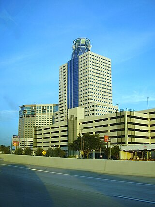
Memorial City is a commercial district in the Memorial area of Houston, Texas, United States. Located along Interstate 10 between Beltway 8 and Bunker Hill Road, the district is anchored by Memorial City Mall, the nation's 38th-largest shopping mall; Memorial Hermann Memorial City Medical Center; CityCentre, a high-density mixed-use development; and Town & Country Village, a shopping center. Large portions of Memorial City are owned by development firm MetroNational, which has developed 265 acres in the area, including the entirety of the mall.
Aristoi Classical Academy is a K-12 open-enrollment public charter school based in Katy, Texas. The school originally opened in 1996 and was then called West Houston Charter School. The school was renamed in 2006. It has three campuses, two of which serve a portion of the Katy Independent School District area, and the remaining one the Cypress Fairbanks Independent School District area.

Forum Park is a community in Houston, Texas. It is bounded by Texas State Highway Beltway 8, U.S. Route 59, and Bissonnet Road. A portion of the community resides in the Greater Sharpstown district.
Cottage Grove is a community in Houston, Texas.

Mirus Academy is a private school high school located in Katy, Texas in the United States of America. The school serves the City of Katy, Texas and Greater Houston area.
Sagemont is a neighborhood in far southeast Houston, Texas, south of Beltway 8.
Greenwood Forest is an unincorporated area in Harris County, Texas, United States. It is within the Champions region of area 649 acres (263 ha). According to Louis B. Parks of the Houston Chronicle, the commuting distance to Downtown Houston in 2004 was 20 minutes.
