Cannock Chase District

Last updated

Cannock Chase District
Cannock Chase Sherbrook Valley (37096640) (cropped).jpg
Cannock Chase, the landscape which gives its name to the district.
Cannock Chase UK locator map.svg
Cannock Chase shown within Staffordshire
Sovereign state United Kingdom
Constituent country England
Region West Midlands
Non-metropolitan county Staffordshire
Status Non-metropolitan district
Admin HQ Cannock
Incorporated1 April 1974
Government
  TypeNon-metropolitan district council
  BodyCannock Chase Council
   MP Amanda Milling
Area
  Total30.5 sq mi (78.9 km2)
  Rank219th (of 296)
Population
 (2022)
  Total101,140
  Rank239th (of 296)
  Density3,300/sq mi (1,300/km2)
Ethnicity (2021)
[1]
   Ethnic groups
List
Religion (2021)
[1]
   Religion
List
Time zone UTC0 (GMT)
  Summer (DST) UTC+1 (BST)
ONS code 41UB (ONS)
E07000192 (GSS)
OS grid reference SK0200614806

Cannock Chase is a local government district in Staffordshire, England. It is named after and covers a large part of Cannock Chase, a designated Natural Landscape. The council is based in the town of Cannock. The district also contains the towns of Hednesford and Rugeley, as well as a number of villages and surrounding rural areas.

Contents

The district borders South Staffordshire to the west, the Borough of Stafford to the north, Lichfield District to the east, and the Metropolitan Borough of Walsall to the south.

History

The district was created on 1 April 1974 under the Local Government Act 1972, covering two former districts plus a single parish from a third, which were all abolished at the same time: [3]

The new district was named Cannock Chase after the landscape and former royal forest which covers much of the area. [4]

Governance

Cannock Chase Council
Cannock Chase Council logo.svg
Type
Type
Leadership
Steve Thornley,
Labour
since 22 May 2024
Tony Johnson,
Labour
since 24 May 2023
Tim Clegg [lower-alpha 1]
since 1 June 2021 [5]
Structure
Seats36 councillors
Political groups
Administration (21)
  Labour (21)
Other parties (15)
  Conservative (10)
  Green (5)
Elections
First past the post
Last election
2 May 2024
Next election
May 2026
Meeting place
Headquarters, Cannock Chase District Council - geograph.org.uk - 1991619.jpg
Civic Centre, Beecroft Road, Cannock, WS11 1BG
Website
www.cannockchasedc.gov.uk

Cannock Chase District Council, which styles itself "Cannock Chase Council", provides district-level services. County-level services are provided by Staffordshire County Council. Much of the district is also covered by civil parishes, which form a third tier of local government. [6] [7]

The council's logo is a deer, referencing the area's past as a royal hunting forest and the fact that deer are common in the area. A survey in 2022 found that the deer population was growing. [8]

Political control

Following the May 2024 local elections, the Council is being run by a Labour Majority Adminstration, led by Labour councillor Tony Johnson. [9]

The first elections to the council were held in 1973, initially operating as a shadow authority alongside the outgoing authorities before coming into its powers on 1 April 1974. Political control of the council since 1974 has been as follows: [10] [11]

Party in controlYears
Labour 1974–1982
No overall control 1982–1987
Labour 1987–2003
No overall control 2003–2012
Labour 2012–2019
No overall control 2019–2021
Conservative 2021–2023
No overall control 2023–2024
Labour 2024-present

Leadership

The leaders of the council since 2005 have been: [12]

CouncillorPartyFromTo
Neil Stanley [13] Liberal Democrats pre-20058 May 2011
George Adamson Labour 25 May 201119 May 2021
Olivia Lyons Conservative 19 May 202124 May 2023
Tony Johnson Labour 24 May 2023

Composition

Following the 2024 election and a subsequent change of allegiance in September 2023, the composition of the council was: [14]

PartyCouncillors
Labour 21
Conservative 10
Green 5
Total36

The next election is due in 2026.

Elections

From 2002 (when the district's ward boundaries were last changed) up to May 2024, the council was comprised of 41 councillors representing 15 wards, with each ward electing two or three councillors. Elections are held three years out of every four, with roughly a third of the council elected each time for a four-year term of office. Staffordshire County Council elections are held in the fourth year of the cycle when there are no district council elections. [15]

The new ward boundaries drawn up by the Local Boundary Commission for England came into effect from the May 2024 election, reducing the number of councillors to 36 and the number of wards to 12. [16]

The district covers the same area as the Cannock Chase (UK Parliament constituency). Until the 2010 general election the constituency also included the adjacent village of Huntington in South Staffordshire. From 2010 onwards the constituency has exactly the same boundaries as the district. [7]

Premises

The council is based at the Civic Centre on Beecroft Road in Cannock. [17] The building was purpose-built for the council between 1978 and 1981. [18]

Demography

According to data from the 2011 United Kingdom census, Cannock Chase has a population of 100,600, with 49,500 males and 51,100 females. 62.5% of the population is between the ages of 1664, of which 88.7% is economically active, 11.2% above the West Midlands regional average. [19]

Media

In terms of television, the area is served by BBC West Midlands and ITV Central (West) broadcasting from Birmingham. Television signals are received the Sutton Coldfield TV transmitter. [20]

Radio stations for the area are:

The Express & Star is the local newspaper that cover the district. [22]

Towns and parishes

Much of the district is covered by eight civil parishes. The exception is certain parts of Cannock, which are unparished. [7] The parish councils for Hednesford and Rugeley have declared their parishes to be towns, allowing them to take the style "town council". [23]

When the district was created in 1974 it only contained one parish, being Brindley Heath; the former Rugeley Urban District and Cannock Urban District were both unparished. In 1988 two parishes called Rugeley and Brereton were created covering the former Rugeley Urban District, and four parishes called Bridgtown, Cannock Wood, Heath Hayes and Wimblebury, and Norton Canes were created covering parts of the former Cannock Urban District. [24] The parish of Hednesford was subsequently created in 2000 from another part of the former Cannock Urban District. [25]

The parishes are:

Other areas and settlements include:

Related Research Articles

<span class="mw-page-title-main">Cannock</span> Market town in Staffordshire, England

Cannock is a town in the Cannock Chase district in the county of Staffordshire, England. It had a population of 29,018. Cannock is not far from the towns of Walsall, Burntwood, Stafford and Telford. The cities of Lichfield and Wolverhampton are also nearby.

<span class="mw-page-title-main">Rugeley</span> Town in Staffordshire, England

Rugeley is a market town and civil parish in the Cannock Chase District, in Staffordshire, England. It lies on the north-eastern edge of Cannock Chase next to the River Trent; it is situated 8 miles (13 km) north of Lichfield, 10 miles (16 km) south-east of Stafford, 5 miles (8.0 km) north-east of Hednesford and 11 miles (18 km) south-west of Uttoxeter. At the 2021 Census, the population was 26,156.

<span class="mw-page-title-main">East Staffordshire</span> Non-metropolitan district and Borough in England

East Staffordshire is a local government district with borough status in Staffordshire, England. The council is based in Burton upon Trent. The borough also contains the town of Uttoxeter and numerous villages and surrounding rural areas.

<span class="mw-page-title-main">South Derbyshire</span> Non-metropolitan district in England

South Derbyshire is a local government district in Derbyshire, England. The district covers the towns of Melbourne and Swadlincote as well as numerous villages and hamlets such as Hilton, Hatton, Etwall, Aston-on-Trent, Repton, Weston-on-Trent and Willington. About a third of the National Forest lies within the district.

<span class="mw-page-title-main">South Staffordshire</span> Non-metropolitan district in England

South Staffordshire is a local government district in Staffordshire, England. Its council is based in Codsall. Other notable settlements include Brewood, Cheslyn Hay, Coven, Essington, Featherstone, Four Ashes, Great Wyrley, Huntington, Kinver, Landywood, Penkridge, Perton, Wedge Mills, Weston-under-Lizard and Wombourne. The district covers a largely rural area lying immediately to the west and north-west of the West Midlands conurbation.

<span class="mw-page-title-main">Burntwood</span> Human settlement in England

Burntwood is a former mining town and civil parish in the Lichfield District in Staffordshire, England, approximately 4 miles (6 km) west of Lichfield and north east of Brownhills. The town had a population of 26,049 and forms part of Lichfield district. The town forms one of the largest urbanised parishes in England. Samuel Johnson opened an academy in nearby Edial in 1736. The town is home to the smallest park in the UK, Prince's Park, which is located next to Christ Church on the junction of Farewell Lane and Church Road. The town expanded in the nineteenth century around the coal mining industry.

<span class="mw-page-title-main">Lichfield District</span> Non-metropolitan district in England

Lichfield District is a local government district in Staffordshire, England. The district is named after its largest settlement, the city of Lichfield, which is where the district council is based. The district also contains the towns of Burntwood and Fazeley, along with numerous villages and surrounding rural areas, including part of Cannock Chase, a designated Area of Outstanding Natural Beauty.

<span class="mw-page-title-main">Hednesford</span> Market town in Staffordshire, England

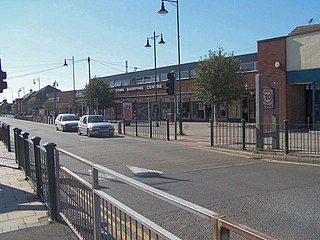
Hednesford is a market town and civil parish in the Cannock Chase district of Staffordshire, England. The Cannock Chase area of natural beauty is to the north of the town. Hednesford is also 1 mile (1.6 km) to the north of Cannock and 5 miles (8.0 km) to the south of Rugeley. The population at the 2011 census was 17,343.

<span class="mw-page-title-main">Chase Line</span>

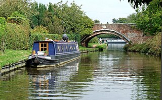
The Chase Line is a suburban railway line in the West Midlands region of England. It runs from its southern terminus, Birmingham New Street, to Walsall, and then Rugeley Trent Valley in Staffordshire, where it joins the Trent Valley line. The name of the line refers to Cannock Chase which it runs through at its northern end.

<span class="mw-page-title-main">Cannock Chase (UK Parliament constituency)</span> Parliamentary constituency in the United Kingdom, 1997 onwards

Cannock Chase is a constituency in Staffordshire represented in the House of Commons of the UK Parliament since 2015 by Amanda Milling of the Conservative Party. She served as the Minister for Asia and the Middle East in the Foreign, Commonwealth and Development Office from 16 September 2021 to 7 September 2022.

Brindley Heath is an area of heath land on Cannock Chase situated between Hednesford and Rugeley in the Cannock Chase District of Staffordshire, England. The area also forms a civil parish, which at the 2001 census, had a population of 862, decreasing to 827 at the 2011 Census.

Cannock Chase District Council elections are held three years out of every four, with a third of the council elected each time. Cannock Chase District Council is the local authority for the non-metropolitan district of Cannock Chase in Staffordshire, England. Since the last boundary changes in 2002, 41 councillors have been elected from 15 wards.

<span class="mw-page-title-main">Hednesford railway station</span> Railway station in Staffordshire, England

Hednesford railway station serves the town of Hednesford in Staffordshire, England. The station, and all trains serving it, are operated by West Midlands Railway.

<span class="mw-page-title-main">Staffordshire County Council</span> British administrative authority

Staffordshire County Council is the upper-tier local authority for the non-metropolitan county of Staffordshire, England. The non-metropolitan county differs from the ceremonial county, which additionally includes Stoke-on-Trent.

<span class="mw-page-title-main">Bridgtown</span> Human settlement in England

Bridgtown is a village and civil parish, in the Cannock Chase District of Staffordshire, England. It is situated on the A5 between Cannock and Great Wyrley. There are multiple industrial and retail estates in and around the village, as well as residential areas.

<span class="mw-page-title-main">Heath Hayes and Wimblebury</span> Civil parish in Staffordshire, England

Heath Hayes and Wimblebury is a civil parish in the Cannock Chase District of Staffordshire, England. It comprises the once separate villages of Heath Hayes and Wimblebury, which following recent housing development have now become joined. It is one of the most affluent areas in the borough, being home to several good schools and being popular with commuters due to the excellent transport links - with both Cannock and Hednesford train stations nearby and also being close to the M6, M6 toll and A5. It has also seen the recent development of the McArthur Glen designer outlet West Midlands and is situated directly adjacent to Cannock Chase area of outstanding natural beauty (AONB).

<span class="mw-page-title-main">2023 Cannock Chase District Council election</span> 2023 English local election

The 2023 Cannock Chase District election took place on 4 May 2023 to elect 17 of the 41 councillors on Cannock Chase District Council in Staffordshire, England. on the same day as other local elections in England, including to eight parish councils in the district. The usual nominal third of the council was up for election, plus there were two vacancies to be filled, meaning a total of 17 councillors were elected.

<span class="mw-page-title-main">2024 Cannock Chase District Council election</span> 2024 English local election

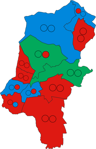
The 2024 Cannock Chase District Council election took place on Thursday 2 May 2024 to elect councillors on Cannock Chase District Council in Staffordshire. All 36 seats on the council were elected following boundary changes. This election was held on the same day as other local elections in England and the election of Staffordshire's Police, Fire and Crime Commissioner.

References

  1. Joint chief executive with Stafford Borough Council
  1. 1 2 UK Census (2021). "2021 Census Area Profile – Cannock Chase Local Authority (E07000192)". Nomis. Office for National Statistics . Retrieved 5 January 2024.
  2. "Walsall Demographics | Age, Ethnicity, Religion, Wellbeing". Varbes. Retrieved 10 February 2023.
  3. "The English Non-metropolitan District (Definition) Order 1972", legislation.gov.uk , The National Archives, SI 1972/2039, retrieved 17 November 2023
  4. "The English Non-metropolitan Districts (Names) Order 1973", legislation.gov.uk , The National Archives, SI 1973/551, retrieved 31 May 2023
  5. Ashdown, Kerry (22 May 2021). "Councils to share chief executive despite concern over splitting time between two boroughs". Stoke-on-Trent Live. Retrieved 27 December 2023.
  6. "Local Government Act 1972", legislation.gov.uk , The National Archives, 1972 c. 70, retrieved 31 May 2023
  7. 1 2 3 "Election Maps". Ordnance Survey. Retrieved 27 December 2023.
  8. "Cannock Chase deer count suggests growing population". BBC News. 15 April 2013. Retrieved 28 May 2022.
  9. Lawson, Eleanor (25 May 2023). "Labour forms coalition with Greens and Lib Dems in Cannock Chase to run council". Express and Star. Retrieved 27 December 2023.
  10. "Compositions calculator". The Elections Centre. Retrieved 9 September 2022.
  11. "Cannock Chase". BBC News Online . 19 April 2008. Retrieved 17 October 2009.
  12. "Council minutes". Cannock Chase District Council. Retrieved 17 September 2022.
  13. "Cannock Lib Dem leader loses to Labour's Gordon Brown". BBC News. 6 May 2011. Retrieved 17 September 2022.
  14. "Local elections 2023: live council results for England". The Guardian.
  15. "The District of Cannock Chase (Electoral Changes) Order 2001", legislation.gov.uk , The National Archives, SI 2001/1442, retrieved 27 December 2023
  16. "The Cannock Chase (Electoral Changes) Order 2023", legislation.gov.uk , The National Archives, SI 2023/1023, retrieved 27 December 2023
  17. "Cannock Chase Council" . Retrieved 27 December 2023.
  18. "Royal brick graces new HQ". Rugeley Times. 1 August 1981. p. 3. Retrieved 27 December 2023.
  19. "Labour market profile - Cannock Chase". Nomis. Retrieved 6 July 2023.
  20. "Sutton Coldfield (Birmingham, England) Full Freeview transmitter". UK Free TV. 1 May 2004. Retrieved 16 April 2024.
  21. "Cannock Chase Radio" . Retrieved 16 April 2024.
  22. "Express & Star". British Papers. 12 February 2014. Retrieved 16 April 2024.
  23. "Parish and Town Councils". Cannock Chase Council. Retrieved 27 December 2023.
  24. "Cannock Chase (Parishes) Order 1987" (PDF). Local Government Boundary Commission for England. The National Archives. Retrieved 27 December 2023.
  25. Langston, Brett. "Cannock Chase Registration District". UKBMD. Retrieved 27 December 2023.

Further reading

52°43′50″N1°58′13″W / 52.73056°N 1.97028°W / 52.73056; -1.97028