
Wainwright Airport is a public use airport located in Wainwright, a city in the North Slope Borough of the U.S. state of Alaska. The airport is owned by the North Slope Borough.
Nikolski Air Station is an unattended airport located in Nikolski on Umnak Island in the Aleutians West Census Area of the U.S. state of Alaska. This former military airport is now owned by The Aleut Corporation.

Barter Island LRRS Airport is a public/military airport located near the city of Kaktovik on Barter Island, in the North Slope Borough, located 312 miles (502 km) east of Point Barrow, Alaska. The airport is owned by the North Slope Borough. It is also known as Barter Island Airport or Kaktovik Airport. The acronym LRRS stands for Long Range Radar Site or Long Range Radar Station.
Cape Lisburne LRRS Airport is a military airport located on Cape Lisburne, at the northwest point of the Lisburne Peninsula in the North Slope Borough of the U.S. state of Alaska. The airport is owned by the U.S. Air Force. It is also known as Cape Lisburne Airport.
Tin City LRRS Airport is a military airport located one nautical mile (1.85 km) east of the historic location of Tin City, in the Nome Census Area of the U.S. state of Alaska. It is owned by the U.S. Air Force.
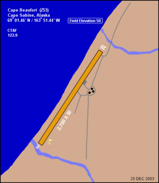
Cape Sabine DEW Line Station is a closed United States Air Force facility. It was formerly a Distant Early Warning Line Intermediate type radar station. It was closed in 1963 and has been abandoned ever since. Title to the property has been transferred from the Air Force to the Cully Corporation.
Big Mountain Air Force Station is a military use airstrip located near Big Mountain, in the Lake and Peninsula Borough of the U.S. state of Alaska. The airstrip was built to support the Big Mountain Radio Relay Station, an abandoned Air Force facility located 220 miles (350 km) southwest of Anchorage on the south shore of Iliamna Lake.
Boswell Bay Airport is owned by the U.S. Forest Service and is located near Boswell Bay, in the Valdez–Cordova Census Area, Alaska of the U.S. state of Alaska. The airfield was constructed in 1968 to serve the nearby White Alice radar site, now abandoned.
Point Lay LRRS Airport is a public and military use airport owned by the United States Government and located in Point Lay, in the North Slope Borough of the U.S. state of Alaska. It is also known as Point Lay Airport. The acronym LRRS stands for Long Range Radar Site or Long Range Radar Station.
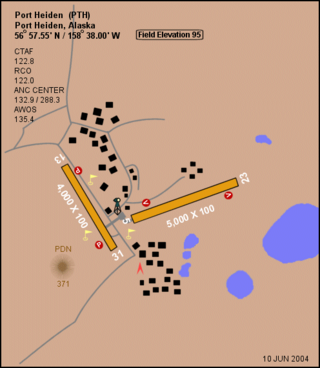
Port Heiden Airport is a state-owned public-use airport located six nautical miles northeast of the central business district of Port Heiden, in the Lake and Peninsula Borough of the U.S. state of Alaska. Scheduled airline service to King Salmon Airport is provided by Peninsula Airways (PenAir).
Port Moller Airport is a publicly owned, private-use airport located 87 nautical miles northeast of the central business district of Cold Bay, in the Aleutians East Borough of the U.S. state of Alaska. It is owned by the U.S. Department of the Interior, Bureau of Land Management. It was previously known as Port Moller Air Force Station.
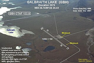
Galbraith Lake Airport is a state-owned, public-use airport located at Galbraith Lake in the North Slope Borough of the U.S. state of Alaska. The Arctic National Wildlife Refuge has an office at the airport. The lake and airport are located west of the Dalton Highway and north of the Trans-Alaska Pipeline System's Pump Station 4. According to the FAA's National Plan of Integrated Airport Systems for 2009–2013, it was classified as a general aviation airport.
Point Lonely Short Range Radar Site is a United States Air Force Short Range Radar Site located in the North Slope Borough of the U.S. state of Alaska, 84 miles (135 km) east-southeast of Point Barrow, Alaska. It is not open for public access.
Cape Romanzof LRRS Airport is a military airstrip located six nautical miles southeast of Cape Romanzof, in the Kusilvak Census Area of the U.S. state of Alaska. It is not open for public use.
Cape Newenham LRRS Airport is a military airstrip located one nautical mile southeast of Cape Newenham, in the Dillingham Census Area of the U.S. state of Alaska. It is not open for public use.
Indian Mountain LRRS Airport is a military airstrip located south of Utopia Creek, in the Yukon–Koyukuk Census Area of the U.S. state of Alaska. The airstrip is also located 15.8 miles (25.4 km) east-southeast of Hughes, Alaska. It is not open for public use.
Tatalina LRRS Airport is a military airstrip located seven nautical miles south of Takotna, in the Yukon–Koyukuk Census Area of the U.S. state of Alaska. The airstrip is also located 12.9 miles (20.8 km) west-southwest of McGrath, Alaska. It is not open for public use.
Sparrevohn LRRS Airport is a military airstrip located south of Sparrevohn, in the Bethel Census Area of the U.S. state of Alaska. The airstrip is also located 129 miles (208 km) south of McGrath, Alaska, and 188 miles (303 km) west of Anchorage, Alaska. It is not open for public use.
Cold Bay Air Force Station is a closed United States Air Force General Surveillance Radar station. It is located 625 miles (1,006 km) southwest of Anchorage, Alaska.
Driftwood Bay Air Force Station is a private use military airstrip located 13 nautical miles northwest of Unalaska Island, in the Aleutians East Borough of the U.S. state of Alaska. It is privately owned by the United States Air Force. The facility is not open for public use.
