Carmental Gate

Last updated
The student's manual of ancient geography, based upon the Dictionary of Greek and Roman geography (1861) (14768984432).jpg

The Carmental Gate, also known by its Latin name as the Porta Carmentalis, was a double gate in the Servian Walls of ancient Rome. It was named for a nearby shrine to the goddess or nymph Carmenta, [1] whose importance in early Roman religion is also indicated by the assignment of one of the fifteen flamines to her cult, and by the archaic festival in her honor, the Carmentalia. The shrine was to the right as one exited the gate.

Contents

The gate's two arches seem to have been set at angles, and were known by separate names. It was unlucky to leave the city through the arch called Porta Scelerata ("Accursed Gate"), which was supposed to have been named for the military disaster at Cremera in 479 or 478 BC, since the 306 Fabii who died had departed through it. [2] The Servian Walls, however, did not exist at that time. [3] The accursed nature of the gate probably derives from the transport of corpses out of the city proper to funeral pyres on the Campus Martius. [4] The family tomb of the Claudii was located outside the Carmental Gate. [5]

The other gate was the Porta Triumphalis. A governor returning from his province could not enter through this gate unless he had been awarded a triumph. It therefore must have been routine to use the Porta Scelerata for entering, and the Triumphalis for exiting. Funeral processions reversed the normal direction of traffic flow for the Scelerata, as the triumphal procession did for the Triumphalis. Augustus was accorded the special honor of having his funeral procession exit by the Triumphalis. [6]

The temples of Mater Matuta, [7] Fortuna, [7] Juno Sospita, and Spes were located nearby, the later two at the Forum Olitorium, Rome's vegetable market. [8]

The Carmental Gate was rebuilt by Domitian and topped with a sculpture group of a triumphal chariot drawn by elephants, to celebrate his campaign against the Sarmatians and the Marcomanni. [9] The gate is depicted in relief sculpture dating to the reign of Marcus Aurelius. [10] It was eventually destroyed by order of the emperor Constantine I. [11]

The Vicus Iugarius forked just before reaching the Carmental Gate, with one branch passing through the Forum Holitorium by making a right curve around the foot of the Capitoline Hill, and the other passing through the Forum Boarium to the mouth of the Cloaca Maxima on the Tiber. The precise location of the Carmental Gate itself remains unclear, despite excavations in the area from the late 1930s onward. [12] Livy names the Carmental Gate as the point of entry for a ritual procession undertaken in 207 BC as part of an expiatory sacrifice for Juno. Two white cows were led from the Temple of Apollo through the gate and along the Vicus Iugarius to the Forum. [13]

Related Research Articles

<span class="mw-page-title-main">Stata Mater</span> Ancient Roman goddess

In ancient Roman religion, Stata Mater was a compital goddess who protected against fires. She had an image (simulacrum) in the Forum, and her cultus, as Festus notes, spread from there throughout the neighborhoods (vici) of the city.

<span class="mw-page-title-main">Porta Capena</span>

Porta Capena was a gate in the Servian Wall in Rome, Italy. The gate was located in the area of Piazza di Porta Capena, where the Caelian, Palatine and Aventine hills meet. Probably its exact position was between the entrance of Via di Valle delle Camene and the beginning of Via delle Terme di Caracalla, facing the curved side of the Circus Maximus.

<span class="mw-page-title-main">Triumphal arch</span> Monumental structure in the shape of an archway

A triumphal arch is a free-standing monumental structure in the shape of an archway with one or more arched passageways, often designed to span a road. In its simplest form a triumphal arch consists of two massive piers connected by an arch, crowned with a flat entablature or attic on which a statue might be mounted or which bears commemorative inscriptions. The main structure is often decorated with carvings, sculpted reliefs, and dedications. More elaborate triumphal arches may have multiple archways.

<span class="mw-page-title-main">Forum Holitorium</span>

The Forum Holitorium or Olitorium is an archaeological area of Rome, Italy, on the slopes of the Capitoline Hill. It was located outside the Carmental Gate in the Campus Martius, crowded between the cattle market and buildings located in the Circus Flaminius.

<span class="mw-page-title-main">Servian Wall</span> Defensive barrier around the ancient city of Rome

The Servian Wall was an ancient Roman defensive barrier constructed around the city of Rome in the early 4th century BC. The wall was built of volcanic tuff and was up to 10 m (33 ft) in height in places, 3.6 m (12 ft) wide at its base, 11 km (6.8 mi) long, and is believed to have had 16 main gates, of which only one or two have survived, and enclosed a total area of 246 hectares. In the 3rd century AD it was superseded by the construction of the larger Aurelian Walls as the city of Rome grew beyond the boundary of the Servian Wall.

<span class="mw-page-title-main">14 regions of Augustan Rome</span> Administrative subdivisions of ancient Rome

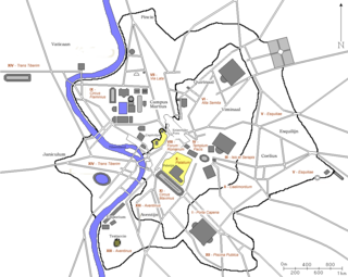
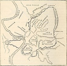
In 7 BC, Augustus divided the city of Rome into 14 administrative regions. These replaced the four regiones—or "quarters"—traditionally attributed to Servius Tullius, sixth king of Rome. They were further divided into official neighborhoods.

<span class="mw-page-title-main">Porta Trigemina</span> Gate in the ancient 4th century Servian Wall of Rome, Italy

The Porta Trigemina was one of the main gates in the ancient 4th century Servian Wall of Rome, Italy. The gate no longer exists, but it is frequently mentioned by ancient authors as standing between the north end of the Aventine Hill and the Tiber River, placing it near the southeastern end of the Forum Boarium. The Clivus Publicius descended from the Aventine to the Porta Trigemina.

<span class="mw-page-title-main">Porta Esquilina</span>

The Porta Esquilina was a gate in the Servian Wall, of which the Arch of Gallienus is extant today. Tradition dates it back to the 6th century BC, when the Servian Wall was said to have been built by the Roman king Servius Tullius. However modern scholarship and evidence from archaeology indicate a date in the fourth century BC. The archway of the gate was rededicated in 262 as the Arch of Gallienus.

<span class="mw-page-title-main">Querquetulanae</span>

In ancient Roman religion and myth, the Querquetulanae or Querquetulanae virae were nymphs of the oak grove (querquetum) at a stage of producing green growth. Their sacred grove (lucus) was within the Porta Querquetulana, a gate in the Servian Wall. According to Festus, it was believed that in Rome there was once an oakwood within the Porta Querquetulana onto the greening of which presided the virae Querquetulanae.

<span class="mw-page-title-main">Piscina Publica</span>

In ancient Rome, the Piscina Publica was a public reservoir and swimming pool located in Regio XII. The region itself came to be called informally Piscina Publica from the landmark. The piscina was situated in the low-lying area between the Via Appia, the Servian Wall, and the northeast slope of the Aventine Hill, an area later occupied by the Baths of Caracalla.

<span class="mw-page-title-main">Porta Caelimontana</span>

The Porta Caelimontana or Celimontana was a gate in the Servian Wall on the rise of the Caelian Hill.

<span class="mw-page-title-main">Arch of Dolabella</span> Ancient Roman arch, a landmark of Rome, Italy

The Arch of Dolabella and Silanus or Arch of Dolabella is an ancient Roman arch. It was built by senatorial decree in 10 AD by the consuls P. Cornelius Dolabella and C. Junius Silanus.

<span class="mw-page-title-main">Porta Fontinalis</span>

The Porta Fontinalis was a gate in the Servian Wall in ancient Rome. It was located on the northern slope of the Capitoline Hill, probably the northeast shoulder over the Clivus Argentarius. The Via Salaria exited through it, as did the Via Flaminia originally, providing a direct link with Picene and Gallic territory. After the Aurelian Walls were constructed toward the end of the 3rd century AD, the section of the Via Flaminia that ran between the Porta Fontinalis and the new Porta Flaminia was called the Via Lata ("Broadway").

The lautumiae were tufa quarries that became a topographical marker in ancient Rome. They were located on the northeast slope of the Capitoline Hill, forming one side of the Graecostasis, where foreign embassies gathered prior to appearing before the Roman Senate.

The Alta Semita was a street in ancient Rome that gave its name to one of the 14 regions of Augustan Rome.

<span class="mw-page-title-main">Regio I Porta Capena</span> Historical region of Rome

The Regio I Porta Capena is the first regio of imperial Rome, under Augustus's administrative reform. Regio I took its name from the Porta Capena, a gate of the Servian Walls, through which the Appian Way entered the city prior to the construction of the Aurelian Walls.

<span class="mw-page-title-main">Vicus Patricius</span> Street in Rome, Italy

Vicus Patricius was a street in ancient Rome, whose route corresponds to that of the present Via Urbana.
It started from the point where the Argiletum branched into clivus Suburanus and vicus Patricius, crossed the Cispian and the Viminal hills and reached the Porta Viminalis in the Servian Wall.

The Porta Naevia was a minor gateway in Rome’s Servian Wall.

The Arch of Domitian was an ancient Roman arch located between the Roman Forum and the Palatine Hill.

References

Citations

  1. Vergil, Aeneid 8.337–341; Dionysius of Halicarnassus 1.32.3; Festus 450 in the edition of Lindsay; Solinus 1.13: Lawrence Richardson, A New Topographical Dictionary of Ancient Rome (Johns Hopkins University Press, 1992), p. 301.
  2. Festus 450L; Ovid, Fasti 2.201–204; Cassius Dio frg. 20.3 (21.3); De viris illustribus 14.3–5; Richardson, A New Topographical Dictionary, p. 301.
  3. Richardson, A New Topographical Dictionary, p. 301.
  4. Richardson, A New Topographical Dictionary, p. 301.
  5. T.P. Wiseman, "The Legends of the Patrician Claudii," in Clio's Cosmetics (Bristol Phoenix Press, 2003 reprint, originally published 1979), p. 94.
  6. Cicero, In Pisonem 55; Josephus, Jewish Wars 7.5.4.130–131; Tacitus, Annales 1.8.4; Suetonius, Augustus 100.2; Cassius Dio 56.42.1; Richardson, A New Topographical Dictionary, p. 301.
  7. 1 2 Christopher Smith, "Worshipping Mater Matuta: Ritual and Context," in Religion in Archaic and Republican Rome and Italy: Evidence and Experience (Edinburgh University Press, 2000), p. 145.
  8. Burn (1871), p. 305.
  9. Martial 8.65.1–12; Richardson, A New Topographical Dictionary, p. 301.
  10. Richardson, A New Topographical Dictionary, p. 301.
  11. Förtsch, Reinhard. (2006) "Arcus: [11] Domitiani." Brills New Pauly. Retrieved from https://referenceworks-brillonline-com.wikipedialibrary.idm.oclc.org/entries/brill-s-new-pauly/arcus-e133120?s.num=0&s.f.s2_parent=s.f.book.brill-s-new-pauly&s.q=arcus.
  12. Richardson, A New Topographical Dictionary, p. 301.
  13. Livy 27.37.11–15; J.J. Pollitt, The Art of Rome, C. 753 B.C.-A.D. 337: Sources and Documents (Cambridge University Press, 1983, originally published in 1966), p. 49.

Bibliography

  • Burn, Robert (1871), Rome and the Campagna: An Historical and Topographical Description of the Site, Buildings, and Neighbourhood of Ancient Rome..., Cambridge: Deighton, Bell, & Co.

41°53′29″N12°28′49″E / 41.89139°N 12.48028°E / 41.89139; 12.48028