According to the International Civil Aviation Organization (ICAO), a runway is a "defined rectangular area on a land aerodrome prepared for the landing and takeoff of aircraft". Runways may be a man-made surface or a natural surface. Runways, taxiways and ramps, are sometimes referred to as "tarmac", though very few runways are built using tarmac. Takeoff and landing areas defined on the surface of water for seaplanes are generally referred to as waterways. Runway lengths are now commonly given in meters worldwide, except in North America where feet are commonly used.

Brisbane Airport is the primary international airport serving Brisbane and South East Queensland. The airport services 31 airlines flying to 50 domestic and 29 international destinations, in total amounting to more than 22.7 million passengers who travelled through the airport in 2016. In 2016, an OAG report named Brisbane airport as the fifth-best performing large-sized airport in the world for on-time performance with 86.71% of arrivals and departures occurring within 15 minutes of their scheduled times, slipping from 88.31% the year before.

Laughlin/Bullhead International Airport is a public use airport located 1.15 miles north of the central business district of Bullhead City, in Mohave County, Arizona, United States. It is owned by Mohave County. The airport is across the Colorado River and one block away from Laughlin, Nevada. Many of the rooms at Laughlin's casino-hotels offer a view of the airport. It was named 2011 Airport of the Year by the Arizona Department of Transportation.
The visual approach slope indicator (VASI) is a system of lights on the side of an airport runway threshold that provides visual descent guidance information during final approach. These lights may be visible from up to 8 kilometres (5.0 mi) during the day and up to 32 kilometres (20 mi) or more at night.

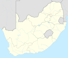
Calicut International Airport, also known as Kozhikode International Airport or Karipur Airport, is an international airport serving the city of Kozhikode, Kerala, India. It is located at Karipur in the Malappuram district of the South Malabar region. It serves the Malabar region, consisting of Malappuram, Wayanad and Palakkad. It is situated 28 km (17 mi) away from Kozhikode and 25 km (16 mi) away from Malappuram. It serves two of the seven metropolitan areas in the state—Kozhikode metropolitan area and Malappuram metropolitan area. The airport opened on 13 April 1988. The airport serves as an operating base for Air India Express and operates Hajj Pilgrimage services to Medina and Jeddah from Kerala. It is the [[List of busiest airports in India|twed Hyderabad in terms of international traffic. It received international airport status on 2 February 2006. It is one of a few airports in the country with a tabletop runway.

Calgary/Springbank Airport or Springbank Airport is an airport located in the Rocky View County community of Springbank, Alberta, an area to the west of Calgary in Alberta, Canada.
Innisfail Aerodrome is located beside Alberta Highway 54, 3.9 nautical miles northwest of Innisfail, Alberta, Canada.
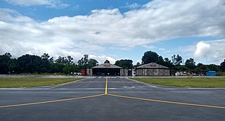
Red Deer Regional Airport is located 6 nautical miles south southwest of Red Deer, Alberta, Canada. The airport serves Charter and General Aviation.

St Mary's Airport or Isles of Scilly Airport is an airport located 1 nautical mile east of Hugh Town on St Mary's in the Isles of Scilly, to the south west of Cornwall, UK. It is the only airport serving the Isles of Scilly, handling all air traffic to and from the Islands. The airport is owned by the Duchy of Cornwall and currently is operated by the Council of the Isles of Scilly.
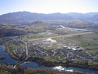
Queenstown Airport is located in Frankton, Otago, New Zealand, and serves the resort town of Queenstown. The airport is 8 km (5.0 mi) from the Queenstown CBD. The airport handled 2.25 million passengers as of 2018 making it the fourth busiest airport in New Zealand by passenger traffic. The airport consists of two runways, and has a single-level terminal building with nine gates. The airport is known for its scenery and challenging approach to land due to nearby high terrain.

An approach lighting system (ALS) is a lighting system installed on the approach end of an airport runway and consisting of a series of lightbars, strobe lights, or a combination of the two that extends outward from the runway end. ALS usually serves a runway that has an instrument approach procedure (IAP) associated with it and allows the pilot to visually identify the runway environment and align the aircraft with the runway upon arriving at a prescribed point on an approach.

Peterborough Business Airport is a privately owned airfield in the English county of Cambridgeshire near the villages of Holme and Conington, 7 NM south of Peterborough.

Kapiti Coast Airport, earlier called Paraparaumu Airport, is on the Kapiti Coast of New Zealand's North Island, between the Wellington dormitory suburbs of Paraparaumu Beach, Paraparaumu to the east, and Raumati Beach to the south. The Wharemauku Stream flows through part of the airport's land.

Bathurst Airport is an airport serving Bathurst, New South Wales, Australia.
Orange Regional Airport is located in the Central Tablelands region of New South Wales between the city of Orange and the town of Blayney. It is located in the area known as Huntley, near Spring Hill and approximately 11 km (6.8 mi) from Orange's business district.

Paraburdoo Airport is an airport serving Paraburdoo, a town in the Pilbara region of Western Australia. The airport is located 5 nautical miles northeast of Paraburdoo. It also serves the town of Tom Price, with bus services completing the extra 71 km to Tom Price.

Kingston Airport, also known as Norman Rogers Airport, is a regional airport located 4.3 nautical miles west of the core of Kingston, Ontario, Canada.
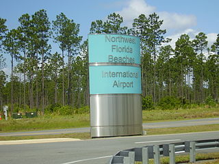
Northwest Florida Beaches International Airport is a public airport 18 miles (29 km) northwest of Panama City, Florida, United States, in Bay County. The airport is owned by the Panama City-Bay County Airport & Industrial District, and is north of Panama City Beach, near West Bay. It replaced Panama City–Bay County International Airport, which was located in Panama City.

Dhule Airport is located at Gondur area in Dhule, Maharashtra, India. This airstrip was constructed in 1974 by the Public Works Department and was transferred to the Maharashtra Airport Development Company (MADC) after its formation in 2002. The Bombay Flying Club leased the airstrip from the MADC and shifted its training operations here in 2009 to avoid the congested air-space of Mumbai.
Pinjore Airfield is being operated as a pilot training institute owned and operated by Haryana Institute of Civil Aviation (HICA) under guidance of Civil Aviation Department, Government of Haryana. The flying school is spread over an area of 96 acres and is located on Pinjore - Baddi main highway near the cities of Kalka and Pinjore in the Panchkula district of the Indian state of Haryana.