
The Dry Fork is a 39.1-mile-long (62.9 km) tributary of the Black Fork of the Cheat River in the Allegheny Mountains of eastern West Virginia, USA. Via the Black Fork, the Cheat, and the Monongahela and Ohio rivers, it is part of the watershed of the Mississippi River. The Dry Fork flows for much of its length in the Monongahela National Forest and drains mostly rural and forested areas. It was traditionally considered one of the five Forks of Cheat.

Glady Fork is a 31.9-mile-long (51.3 km) river in the Allegheny Mountains of eastern West Virginia, USA. It is considered one of the five principal headwaters tributaries of the Cheat River — known as the Forks of Cheat.

Glady is an unincorporated community in Randolph County, West Virginia, United States. Glady is 11 miles (18 km) southeast of Elkins. Glady had a post office, which closed on May 14, 2011.
Duncan is an unincorporated community in Jackson County, West Virginia, United States. Duncan is located on the Right Fork Sandy Creek and County Route 13 8 miles (13 km) west of Reedy. Duncan had a post office, which opened on February 10, 1892, and closed on July 1, 1989.
Rocksdale is an unincorporated community in Calhoun County, West Virginia, United States. Rocksdale is located along County Route 9 at the confluence of the Henry Fork and the West Fork Little Kanawha River, site of now closed post office established in late 1800s with a country store.7.5 miles (12.1 km) east-northeast of Spencer.
Saunders is an unincorporated community in Logan County, West Virginia, United States. Saunders is located on County Highway 16 near Buffalo Creek, 12 miles (19 km) east-northeast of Man.
Sulphur Springs is an unincorporated community in Logan County, West Virginia, United States. Sulphur Springs is located along Copperas Mine Fork and County Route 9/2 6.1 miles (9.8 km) west-southwest of Logan.
Beebe is an unincorporated community in Logan County, West Virginia, United States. Beebe is located along Copperas Mine Fork and County Route 9/2 4.1 miles (6.6 km) west-southwest of Logan.
Packsville is an unincorporated community in Raleigh County, West Virginia, United States. Packsville is located on the Little Marsh Fork 4.4 miles (7.1 km) south-southeast of Sylvester.
Canfield is an unincorporated community in Randolph County, West Virginia, United States. Canfield is located along U.S. Route 33 and West Virginia Route 55 1.8 miles (2.9 km) east-southeast of Elkins.
Elkwater is an unincorporated community in Randolph County, West Virginia, United States. Elkwater is located on U.S. Route 219 and West Virginia Route 55 along the Tygart Valley River, 5.6 miles (9.0 km) south-southwest of Huttonsville.
Hazelwood is an unincorporated community in Randolph County, West Virginia, United States. Hazelwood is located along the Tygart Valley River on U.S. Route 219, U.S. Route 250, West Virginia Route 55, and West Virginia Route 92 4.5 miles (7.2 km) south of Elkins.
Upper Mingo is an unincorporated community in southern Randolph County, West Virginia, United States. Upper Mingon is located along the Tygart Valley River on U.S. Route 219 and West Virginia Route 55, 17 miles (27 km) south-southwest of Mill Creek.
Bemis is an unincorporated community in Randolph County, West Virginia, USA. It is located on Shavers Fork, along County Route 22, some 9.8 miles (15.8 km) southeast of Elkins.
Shively is an unincorporated community in Logan County, West Virginia, United States. Shively is located on County Route 3 and the Smokehouse Fork 5.5 miles (8.9 km) west of Chapmanville.
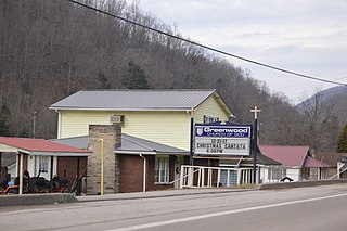
Greenwood is an unincorporated community in Boone County, West Virginia, United States. Greenwood is located along West Virginia Route 85 and Pond Fork 18 miles (29 km) south-southeast of Madison.
Little Italy is an unincorporated community in Randolph County, West Virginia, USA. Little Italy is located on Gandy Creek and County Route 29/5 1.3 miles (2.1 km) south of Whitmer and 18.5 miles (29.8 km) east-southeast of Elkins.
Meadowdale is an unincorporated community in Jackson County, West Virginia, United States. Meadowdale is located on County Route 13 and the Right Fork Sandy Creek 8.1 miles (13.0 km) northeast of Ripley. Meadowdale once had a post office, which is now closed.
Toney Fork is an unincorporated community in Wyoming County, West Virginia, United States. Toney Fork is located on West Virginia Route 85 at the confluence of the Clear Fork and the Toney Fork, 2 miles (3.2 km) northeast of Oceana.


