Barbour County is a county in north-central West Virginia, US. At the 2020 census, the population was 15,465. The county seat is Philippi, which was chartered in 1844. Both county and city were named for Philip P. Barbour (1783–1841), a U.S. Congressman from Virginia and Associate Justice of the U.S. Supreme Court. The county was formed in 1843 when the region was still part of the state of Virginia. In 1871, a small part of Barbour County was transferred to Tucker County, West Virginia.
Wood County is a county in the U.S. state of West Virginia. As of the 2010 census, the population was 86,956, making it West Virginia's fifth-most populous county. Its county seat is Parkersburg. The county was formed in 1798 from the western part of Harrison County and named for James Wood, governor of Virginia from 1796 to 1799.
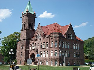
Taylor County is a county in the U.S. state of West Virginia. As of the 2010 census, the population was 16,895. Its county seat is Grafton. The county was formed in 1844 and named for Senator John Taylor of Caroline.

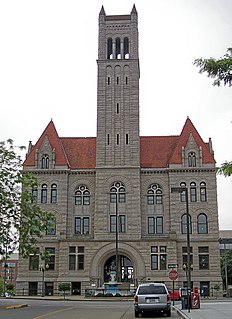
Randolph County is a county located in the U.S. state of West Virginia. As of the 2010 census, the population was 29,405. Its county seat is Elkins. The county was founded in 1787 and is named for Edmund Jennings Randolph.

Richmond County is a county located on the Northern Neck in the U.S. state of Virginia. As of the 2020 census, the population sits at 8,923. Its county seat is Warsaw. The rural county should not be confused with the large city and state capital Richmond, Virginia. It was formed in 1692 when the first Rappahannock County was divided to form Richmond County and Essex County.

Olive Hill is a home rule-class city along Tygarts Creek in Carter County, Kentucky, in the United States. The population was 1,599 during the year 2010 U.S. Census.

Belington is a town in Barbour County, West Virginia, United States, situated along the Tygart Valley River. The population was 1,804 as of the 2020 census.

Pleasant Valley is a city in Marion County, West Virginia, United States. The population was 3,506 at the 2020 census.

Beverly is a town in Randolph County, West Virginia, USA. It is the oldest settlement in the Tygart River Valley (1787) and was the county seat for over a century—from 1790 until 1899—after which the nearby settlement of Elkins assumed that role following an intense local political "war". It had a population of 702 at the 2010 census.

Elkins is a city in and the county seat of Randolph County, West Virginia, United States. The community was incorporated in 1890 and named in honor of Stephen Benton Elkins, a U.S. Senator from West Virginia. The population was 7,094 at the 2010 census and estimated at 6,990 in 2019. Elkins is home to Davis and Elkins College and to the Mountain State Forest Festival, held in early October every year.

Huttonsville is a town in Randolph County, West Virginia, United States, along the Tygart Valley River. The population was 221 at the 2010 census.

Mill Creek is a town in Randolph County, West Virginia, United States, along the Tygart Valley River. The population was 724 at the 2010 census.

Grafton is a city in and the county seat of Taylor County, West Virginia, United States. The population was 4,729 at the 2020 census. It originally developed as a junction point for the Baltimore and Ohio Railroad, serving numerous branches of a network that was vital to the regional coal industry.

The Monongahela River —often referred to locally as the Mon —is a 130-mile-long (210 km) river on the Allegheny Plateau in north-central West Virginia and southwestern Pennsylvania. The river flows from the confluence of its west and east forks in north-central West Virginia northeasterly into southwestern Pennsylvania, then northerly to Pittsburgh and its confluence with the Allegheny River to form the Ohio River. The river's entire length is navigable via a series of locks and dams.

The Tygart Valley River — also known as the Tygart River — is a principal tributary of the Monongahela River, approximately 135 miles (217 km) long, in east-central West Virginia in the United States. Via the Monongahela and Ohio rivers, it is part of the watershed of the Mississippi River, draining an area of 1,329 square miles (3,440 km2) in the Allegheny Mountains and the unglaciated portion of the Allegheny Plateau.
Valley Head is a census-designated place (CDP) in Randolph County, West Virginia, United States. Valley Head is located on U.S. Route 219, 12 miles (19 km) south-southwest of Huttonsville. Valley Head has a post office with ZIP code 26294. As of the 2010 census, its population was 267.
Dailey is a census-designated place (CDP) in Randolph County, West Virginia, United States. Dailey is located on U.S. routes 219 and 250, 3 miles (4.8 km) south-southwest of Beverly. Dailey has a post office with ZIP code 26259. As of the 2010 census, its population was 114.
Valley Bend is a census-designated place (CDP) in Randolph County, West Virginia, United States. Valley Bend is located on U.S. routes 219 and 250, as well as state routes 55 and 92, 3.5 miles (5.6 km) northwest of Mill Creek. Valley Bend has a post office with ZIP code 26293. As of the 2010 census, its population was 485.

Tygart Valley Homesteads Historic District is a national historic district located near Dailey, Randolph County, West Virginia. It encompasses 337 contributing buildings, three contributing sites, and three contributing structures, associated with a resettlement community established during the Great Depression by the Roosevelt administration. It was the largest of the three resettlement communities in West Virginia, the others being Arthurdale and Eleanor. The first dwellings were constructed in 1934, and the Civilian Conservation Corps built the public water system, draining systems, and culverts. The houses have modest Colonial Revival architecture details and have either a side gable or gambrel roof, referred to as either an "A-Frame" or "Barn House." Other notable buildings include the Dailey Community Center (1937), gas station (1940), The Homestead School (1939), The East Dailey Bridge (1938), Community Farm, The Warehouse, The Woodworking Shop, and The Weaving Shop.
Leading Creek is a tributary of the Tygart Valley River, 17.4 miles (28.0 km) long, in eastern West Virginia in the United States. Via the Tygart Valley, Monongahela and Ohio rivers, it is part of the watershed of the Mississippi River, draining an area of 61 square miles (160 km2) in the Allegheny Mountains. The stream's entire course and drainage basin are in northern Randolph County.

