
Trevi nel Lazio is a town and comune (municipality) in the province of Frosinone in the Italian region of Lazio in the upper valley of the Aniene river.

Pico is a town and comune in the province of Frosinone, in the Lazio region of central Italy. It is bounded by other comunes of San Giovanni Incarico, Campodimele, Pontecorvo, Pastena and Lenola.

Caprese Michelangelo is a village and comune in the province of Arezzo, Tuscany, Italy. It is the birthplace of the Renaissance artist Michelangelo. The village is roughly 100 kilometres (62 mi) east of Florence. The village is situated in the Valtiberina or High Tiber Valley.

San Fele is a town and comune in the province of Potenza in the Basilicata region of southern Italy.
Pescopagano is a town and comune in the province of Potenza, in the region of Basilicata. It is bounded by the comuni of Cairano, Calitri, Castelgrande, Castelnuovo di Conza, Conza della Campania, Laviano, Rapone, Sant'Andrea di Conza, Santomenna.

Goriano Sicoli is a comune and town in the Province of L'Aquila in the Abruzzo region of Italy.

Villa Sant'Angelo is a comune and town in the province of L'Aquila, in the Abruzzo region of Italy, which lies in the Aterno River valley near the convergence of the Sirente and the Gran Sasso mountain ranges. Many of the municipal functions are managed cooperatively with adjacent villages, comprising the Comunità Montana Amiternina.

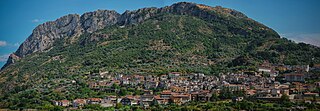
Decollatura is a comune in the province of Catanzaro in the Calabria region of southern Italy. It was the birthplace of the Italian poet Michele Pane (1876–1953).

Motta Santa Lucia is a comune and town in the province of Catanzaro, Calabria, southern Italy.

Agra is a town and comune located in the province of Varese, in the Lombardy region of northern Italy.

Mongrassano is a town and comune of the province of Cosenza in the Calabria region of southern Italy, located 42 kilometers northwest of Cosenza.

Andalo is a comune (municipality) in Trentino in north Italy, with some 1,200 inhabitants in 2021. It is the seat of the Comunità di Valle dell'Altopiano della Paganella.

Roatto is a comune (municipality) in the Province of Asti in the Italian region Piedmont, located about 30 kilometres (19 mi) southeast of Turin and about 14 kilometres (9 mi) northwest of Asti. As of 31 December 2004, it had a population of 385 and an area of 6.5 square kilometres (2.5 sq mi).

Dongo is a comune in the Province of Como in the Italian region Lombardy. It lies on the northwestern shore of Lake Como between Gravedona and Musso at the mouth of the Albano. It is 70 kilometres (43 mi) north of Milan and about 40 kilometres (25 mi) northeast of Como.
Musso is a small town in the Province of Como in the Italian region Lombardy. It lies on the western shore of the northern branch of Lake Como about 35 kilometres (22 mi) northeast of the city of Como. The comune of Musso, which includes the town itself and the surrounding area of lake and mountainside, extends over an area of 412 hectares, with a minimum elevation of 199 metres (653 ft) and a maximum of 1,325 metres (4,347 ft) and has a population of 1,020. It borders the communes of Dongo to the north, Pianello del Lario to the south and Colico across the lake in the Province of Lecco.

Rogolo is a comune (municipality) in the Province of Sondrio in the Italian region of Lombardy, located about 80 kilometres (50 mi) northeast of Milan and about 30 kilometres (19 mi) west of Sondrio. As of 31 December 2004, it had a population of 568 and an area of 13.0 square kilometres (5.0 sq mi). Rogolo borders the following municipalities: Andalo Valtellino, Cosio Valtellino, Delebio, Mantello, Pedesina, Premana, Rasura.

Lugagnano Val d'Arda is a comune (municipality) in the Province of Piacenza in the Italian region Emilia-Romagna.

Vernasca is a comune (municipality) in the Province of Piacenza in the Italian region Emilia-Romagna, located about 120 kilometres (75 mi) northwest of Bologna and about 30 kilometres (19 mi) southeast of Piacenza. It is one of I Borghi più belli d'Italia.
Bivongi is a comune (municipality) in the Province of Reggio Calabria in the Italian region Calabria, located about 50 kilometres (31 mi) southwest of Catanzaro and about 80 kilometres (50 mi) northeast of Reggio Calabria in the Stilaro Valley, at the feet of the Monte Consolino.

The Commune of Scopello is located in the Valsesia region of the Italian Pennine Alps, in the Piedmontese Province of Vercelli. The municipality covers an area of 18.62 square kilometres (7.19 sq mi) and ranges in elevation from 640 to 1,930 metres above sea level. Its main centre of population, and the capoluogo of the commune, is the small town of Scopello which stands on the river Sesia at an elevation of 659 metres (2,162 ft).


