
Fort Sumter is a sea fort built on an artificial island near Charleston, South Carolina to defend the region from a naval invasion. It was built after British forces captured and occupied Washington during the War of 1812 via a naval attack. The fort was still incomplete in 1861 when the Battle of Fort Sumter occurred, sparking the American Civil War. It was severely damaged during the battle and left in ruins. Although there were some efforts at reconstruction after the war, the fort as conceived was never completed. Since the middle of the 20th century, Fort Sumter has been open to the public as part of the Fort Sumter and Fort Moultrie National Historical Park, operated by the National Park Service.
Fort Schuyler is a preserved 19th century fortification in the New York City borough of the Bronx. It houses a museum, the Stephen B. Luce Library, and the Marine Transportation Department and Administrative offices of the State University of New York Maritime College. It is considered one of the finest examples of early 19th century fortifications. The fort was named in honor of Major General Philip Schuyler of the Continental Army.

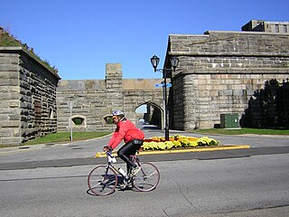
Fort William and Mary was a colonial fortification in Britain's worldwide system of defenses, defended by soldiers of the Province of New Hampshire who reported directly to the royal governor. The fort, originally known as "The Castle," was situated on the island of New Castle, New Hampshire, at the mouth of the Piscataqua River estuary. It was renamed Fort William and Mary circa 1692, after the accession of the monarchs William III and Mary II to the British throne. It was captured by Patriot forces, recaptured, and later abandoned by the British in the Revolutionary War. The fort was renamed Fort Constitution in 1808 following rebuilding. The fort was further rebuilt and expanded through 1899 and served actively through World War II.
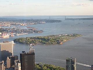
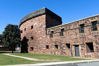
Governors Island is a 172-acre (70 ha) island in New York Harbor, within the New York City borough of Manhattan. It is located approximately 800 yards (730 m) south of Manhattan Island, and is separated from Brooklyn to the east by the 400-yard-wide (370 m) Buttermilk Channel. The National Park Service administers a small portion of the north end of the island as the Governors Island National Monument, including two former military fortifications named Fort Jay and Castle Williams. The Trust for Governors Island operates the remaining 150 acres (61 ha), including 52 historic buildings, as a public park. About 103 acres (42 ha) of the land area is fill, added in the early 1900s to the south of the original island.
Governors Island National Monument is a unit of the United States national park system in New York City. It is located on 22 acres (89,000 m2) of Governors Island, a 172-acre (0.70 km2) island located off the southern tip of Manhattan Island, at the confluence of the Hudson and East rivers in New York Harbor.
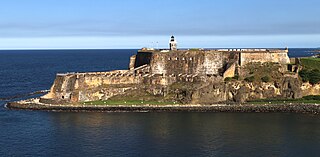
Castillo San Felipe del Morro, most commonly known as El Morro(The Promontory), is a large fortress and citadel in the historic district of Old San Juan, Puerto Rico. Commissioned by Charles I of Spain in 1539, it was first built as a fortified tower in honor of Philip II, who oversaw its expansion into a hornwork fort by 1595. Over the next 200 years, especially in the reign of Charles III, El Morro continued to be developed to reach its current form in 1787. Rising 140 ft from the Atlantic shoreline with 18 to 25 ft thick walls, it stands on a steep, rocky headland promontory on San Juan Islet guarding the entry to San Juan Bay, the harbor of Old San Juan. El Morro, alongside La Fortaleza, San Cristóbal, El Cañuelo, and other forts part of the Walls of Old San Juan, protected strategically and militarily important Puerto Rico, La Llave de las Indias , from invasion by competing world powers during the Age of Sail.

Fort Point, known historically as the Castillo de San Joaquín is a masonry seacoast fortification located on the southern side of the Golden Gate at the entrance to San Francisco Bay. It is also the geographic name of the promontory upon which the fort and the southern approach of the Golden Gate Bridge were constructed.

The Western Heights of Dover are one of the most impressive fortifications in Britain. They comprise a series of forts, strong points and ditches, designed to protect the country from invasion. They were created in the 18th and 19th centuries to augment the existing defences and protect the key port of Dover from both seaward and landward attack; by the start of the 20th century Dover Western Heights was collectively reputed to be the 'strongest and most elaborate' fortification in the country. The Army finally withdrew from the Heights in 1956–61; they are now a local nature reserve.

Fort Mifflin, originally called Fort Island Battery and also known as Mud Island Fort, was commissioned in 1771 and sits on Mud Island on the Delaware River below Philadelphia, Pennsylvania near Philadelphia International Airport.

Fort Wadsworth is a former United States military installation on Staten Island in New York City, situated on The Narrows which divide New York Bay into Upper and Lower halves, a natural point for defense of the Upper Bay and Manhattan beyond. Prior to closing in 1994 it claimed to be the longest continually garrisoned military installation in the United States. It comprises several fortifications, including Fort Tompkins and Battery Weed and was given its present name in 1865 to honor Brigadier General James Wadsworth, who had been killed in the Battle of the Wilderness during the Civil War. Fort Wadsworth is now part of the Staten Island Unit of Gateway National Recreation Area, maintained by the National Park Service.
Fort Totten is a former active United States Army installation in the New York City borough of Queens. It is located on the Willets Point peninsula on the north shore of Long Island. Fort Totten is at the head of Little Neck Bay, where the East River widens to become Long Island Sound. While the U.S. Army Reserve continues to maintain a presence at the fort, the property is now owned by the City of New York. The neighborhood has buses and served by MTA Regional Bus Operations Q13 and Q16 Buses.

Fort Jay is a coastal bastion fort and the name of a former United States Army post on Governors Island in New York Harbor, within New York City. Fort Jay is the oldest existing defensive structure on the island, and was named for John Jay, a member of the Federalist Party, New York governor, Chief Justice of the United States, Secretary of State, and one of the Founding Fathers of the United States. It was built in 1794 to defend Upper New York Bay, but has served other purposes. From 1806 to 1904 it was named Fort Columbus, presumably for explorer Christopher Columbus. Today, the National Park Service administers Fort Jay and Castle Williams as the Governors Island National Monument.

Fort Delaware is a former harbor defense facility, designed by chief engineer Joseph Gilbert Totten and located on Pea Patch Island in the Delaware River. During the American Civil War, the Union used Fort Delaware as a prison for Confederate prisoners of war, political prisoners, federal convicts, and privateer officers. A three-gun concrete battery of 12-inch guns, later named Battery Torbert, was designed by Maj. Charles W. Raymond and built inside the fort in the 1890s. By 1900, the fort was part of a three fort concept, the first forts of the Coast Defenses of the Delaware, working closely with Fort Mott in Pennsville, New Jersey, and Fort DuPont in Delaware City, Delaware. The fort and the island currently belong to the Delaware Department of Natural Resources and Environmental Control (DNREC) and encompass a living history museum, located in Fort Delaware State Park.
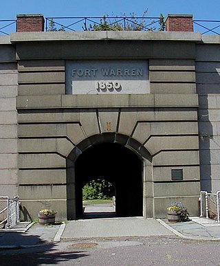
Fort Warren is a historic fort on the 28-acre (110,000 m2) Georges Island at the entrance to Boston Harbor. The fort is named for Revolutionary War hero Dr. Joseph Warren, who sent Paul Revere on his famous ride, and was later killed at the Battle of Bunker Hill. The name was transferred in 1833 from the first Fort Warren – built in 1808 – which was renamed Fort Winthrop.
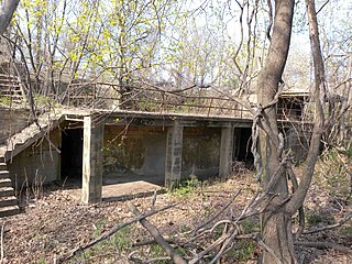
Castle Pinckney is a small masonry fortification constructed by the United States government, in the harbor of Charleston, South Carolina in 1810. It was used very briefly as a prisoner-of-war camp and artillery position during the American Civil War. It was named to the National Register of Historic Places in 1970.

Fort DuPont, named in honor of Rear Admiral Samuel Francis Du Pont, is located between the original Delaware City and the modern Chesapeake and Delaware Canal on the original Reeden Point tract, which was granted to Henry Ward in 1675. Along with two other forts of the Harbor Defenses of the Delaware, it defended the Delaware River and the water approach to Philadelphia from 1900 through 1942. In 2016, the acreage which is not in the state park system was annexed into Delaware City.

Battery Weed is a four-tiered 19th century fortification guarding the Narrows, the main approach from the Atlantic Ocean to New York City. Located on the Staten Island waterfront on the west shore of the Narrows, directly across from Fort Hamilton and the now-destroyed Fort Lafayette in Brooklyn, the fort was intended to protect New York from attack by sea. When built, it was named Fort Richmond, as was a previous fort on the site.

Fort Pickering is a 17th-century historic fort site on Winter Island in Salem, Massachusetts. Fort Pickering operated as a strategic coastal defense and military barracks for Salem Harbor during a variety of periods, serving as a fortification from the Anglo-Dutch Wars through World War II. Construction of the original fort began in 1643 and it saw use as a military installation into the 20th century. Fort Miller in Marblehead also defended Salem's harbor from the 1630s through the American Civil War. Fort Pickering is a First System fortification named for Colonel Timothy Pickering, born in Salem, adjutant general of the Continental Army and secretary of war in 1795. Today, the remains of the fort are open to the public as part of the Winter Island Maritime Park, operated by the City of Salem.

Fort Jefferson is a former U.S. military coastal fortress in the Dry Tortugas National Park of Florida. It is the largest brick masonry structure in the Americas, covering 16 acres (6.5 ha) and made with over 16 million bricks. Among United States forts, only Fort Monroe in Virginia and Fort Adams in Rhode Island are larger. The fort is located on Garden Key in the lower Florida Keys within the Dry Tortugas, 68 miles (109 km) west of the island of Key West. The Dry Tortugas are part of Monroe County in Florida.
Governors Island Golf Course was a military course on Governors Island in New York Harbor, New York City, approximately 800 yards (732 m) from the southern tip of Manhattan Island. The golf course offered one of the most unique golf experiences in New York City due to its views of the Brooklyn and Manhattan skylines, with the Statue of Liberty as a backdrop. It was considered the only golf course in Manhattan as Governors Island is technically part of the borough.


