Catron, Missouri

Last updated

Catron, Missouri
New Madrid County Missouri Incorporated and Unincorporated areas Catron Highlighted.svg
Location of Catron, Missouri
Coordinates: 36°36′40″N89°42′22″W / 36.61111°N 89.70611°W / 36.61111; -89.70611
Country United States
State Missouri
County New Madrid
Area
[1]
  Total0.37 sq mi (0.96 km2)
  Land0.37 sq mi (0.96 km2)
  Water0.00 sq mi (0.00 km2)
Elevation
[2]
282 ft (86 m)
Population
 (2020)
  Total41
  Density110.22/sq mi (42.58/km2)
Time zone UTC-6 (Central (CST))
  Summer (DST) UTC-5 (CDT)
ZIP code
63833
Area code 573
FIPS code 29-12052 [3]
GNIS feature ID2396630 [2]

Catron is a city in New Madrid County, Missouri, United States. The population was 67 at the 2010 census.

Contents

History

A post office called Catron has been in operation since 1893. [4] The community has the name of W. C. Catron, a pioneer citizen. [5]

Geography

According to the United States Census Bureau, the city has a total area of 0.37 square miles (0.96 km2), all land. [6]

Demographics

Historical population
CensusPop.Note
1930 152
1940 25970.4%
1950 2787.3%
1960 177−36.3%
1970 122−31.1%
1980 18047.5%
1990 81−55.0%
2000 68−16.0%
2010 67−1.5%
2020 41−38.8%
U.S. Decennial Census [7]

2010 census

As of the census [8] of 2010, there were 67 people, 28 households, and 17 families living in the city. The population density was 181.1 inhabitants per square mile (69.9/km2). There were 32 housing units at an average density of 86.5 per square mile (33.4/km2). The racial makeup of the city was 83.58% White, 14.93% Black or African American, and 1.49% from two or more races.

There were 28 households, of which 28.6% had children under the age of 18 living with them, 42.9% were married couples living together, 7.1% had a female householder with no husband present, 10.7% had a male householder with no wife present, and 39.3% were non-families. 25.0% of all households were made up of individuals, and 17.8% had someone living alone who was 65 years of age or older. The average household size was 2.39 and the average family size was 2.94.

The median age in the city was 46.5 years. 25.4% of residents were under the age of 18; 6.1% were between the ages of 18 and 24; 18% were from 25 to 44; 35.9% were from 45 to 64; and 14.9% were 65 years of age or older. The gender makeup of the city was 55.2% male and 44.8% female.

2000 census

As of the census [3] of 2000, there were 68 people, 29 households, and 18 families living in the town. The population density was 171.6 inhabitants per square mile (66.3/km2). There were 38 housing units at an average density of 95.9 per square mile (37.0/km2). The racial makeup of the town was 77.94% White and 22.06% African American.

There were 29 households, out of which 24.1% had children under the age of 18 living with them, 51.7% were married couples living together, 10.3% had a female householder with no husband present, and 37.9% were non-families. 34.5% of all households were made up of individuals, and 13.8% had someone living alone who was 65 years of age or older. The average household size was 2.34 and the average family size was 3.11.

In the town the population was spread out, with 22.1% under the age of 18, 7.4% from 18 to 24, 26.5% from 25 to 44, 30.9% from 45 to 64, and 13.2% who were 65 years of age or older. The median age was 40 years. For every 100 females there were 88.9 males. For every 100 females age 18 and over, there were 96.3 males.

The median income for a household in the town was $21,250, and the median income for a family was $40,000. Males had a median income of $18,750 versus $25,625 for females. The per capita income for the town was $9,909. There were 22.2% of families and 42.7% of the population living below the poverty line, including 60.9% of under eighteens and 50.0% of those over 64.

Related Research Articles

<span class="mw-page-title-main">Eagle, Idaho</span> City in Idaho, United States

Eagle is a city in the western United States in Ada County, Idaho, ten miles (16 km) northwest of downtown Boise. The population was 30,346 at the time of the 2020 census.

<span class="mw-page-title-main">Bancroft, Maine</span> Unorganized territory in Maine, United States

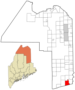
Bancroft is a township in Aroostook County, Maine, United States. The population was 57 at the 2020 census. On July 1, 2015 the town voted to deorganize and become part of the unorganized territory of South Aroostook.

<span class="mw-page-title-main">Hammond, Maine</span> Town in the state of Maine, United States

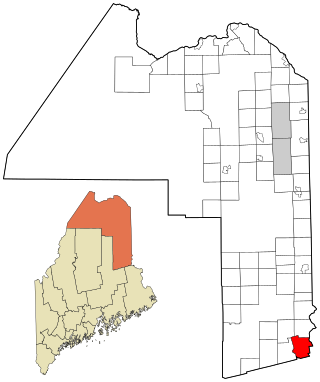
Hammond is a town in Aroostook County, Maine, United States. The population was 91 at the 2020 census.

<span class="mw-page-title-main">Hersey, Maine</span> Town in the state of Maine, United States

Hersey is a town in Aroostook County, Maine, United States. The population was 73 at the 2020 census.

<span class="mw-page-title-main">New Canada, Maine</span> Town in the state of Maine, United States

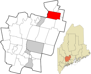
New Canada is a town in Aroostook County, Maine, United States. The population was 310 at the 2020 census.

<span class="mw-page-title-main">Westfield, Maine</span> Town in the state of Maine, United States

Westfield is a town in Aroostook County, Maine, United States. The population was 455 at the 2020 census.

<span class="mw-page-title-main">Weston, Maine</span> Town in the state of Maine, United States

Weston is a town in Aroostook County, Maine, United States. The population was 245 at the 2020 census.

<span class="mw-page-title-main">Benton, Maine</span> Town in the state of Maine, United States

Benton is a town in Kennebec County, Maine, United States. It was formed in 1842, as a subdivision of the town of Clinton. The population was 2,715 at the 2020 census. The town was named for Missouri Senator Thomas Hart Benton.

<span class="mw-page-title-main">Vienna, Maine</span> Town in the state of Maine, United States

Vienna is a town in Kennebec County, Maine, United States. The population was 578 at the 2020 census.

Stoneham is a town in Oxford County, Maine, United States. The population was 261 at the 2020 census.

<span class="mw-page-title-main">Upton, Maine</span> Town in the state of Maine, United States

Upton is a town in Oxford County, Maine, United States. The population was 69 at the 2020 census.

Springfield is a town in Penobscot County, Maine, United States. The population was 293 at the 2020 census.

Winn is a town in Penobscot County, Maine, United States, on the east bank of the Penobscot River. The town was named for John M. Winn, an early landholder. The population was 399 at the 2020 census.

Meddybemps is a town in Washington County, Maine, United States. The population was 139 at the 2020 census.

<span class="mw-page-title-main">Country Life Acres, Missouri</span> Village in Missouri, United States

Country Life Acres is a village in St. Louis County, Missouri, United States. The population was 74 at the 2010 census.

<span class="mw-page-title-main">Westwood, Missouri</span> Village in Missouri, United States

Westwood is a village in west St. Louis County, Missouri, United States. The population was 316 at the 2020 census.

<span class="mw-page-title-main">Windsor Heights, West Virginia</span> Village in West Virginia, United States

Windsor Heights is a village in Brooke County, West Virginia, United States. It is part of the Wheeling, West Virginia Metropolitan Statistical Area. The population was 423 at the 2010 census. Grace Davis was the mayor as of June, 2017.

<span class="mw-page-title-main">Pax, West Virginia</span> Town in West Virginia, United States

Pax is a town in Fayette County, West Virginia, United States. The current mayor of Pax is William F. Hughes. The population was 167 at the 2010 census.

<span class="mw-page-title-main">Harman, West Virginia</span> Town in West Virginia, United States

Harman is a town in Randolph County, West Virginia, United States. The population was 96 at the 2020 census.

<span class="mw-page-title-main">North Hills, West Virginia</span> Town in West Virginia, United States

North Hills is a town in Wood County, West Virginia, United States. It is a suburb of Parkersburg. The population was 837 at the 2020 census. North Hills was incorporated on February 15, 1979.

References

  1. "ArcGIS REST Services Directory". United States Census Bureau. Retrieved August 28, 2022.
  2. 1 2 U.S. Geological Survey Geographic Names Information System: Catron, Missouri
  3. 1 2 "U.S. Census website". United States Census Bureau . Retrieved January 31, 2008.
  4. "Post Offices". Jim Forte Postal History. Retrieved November 19, 2016.
  5. "New Madrid County Place Names, 1928–1945". The State Historical Society of Missouri. Archived from the original on June 24, 2016. Retrieved November 19, 2016.
  6. "US Gazetteer files 2010". United States Census Bureau. Archived from the original on July 2, 2012. Retrieved July 8, 2012.
  7. "Census of Population and Housing". Census.gov. Retrieved June 4, 2015.
  8. "U.S. Census website". United States Census Bureau . Retrieved July 8, 2012.