
Central Europe is a geographical region of Europe between Eastern, Southern, Western and Northern Europe. Central Europe is known for its cultural diversity; however, countries in this region also share certain historical and cultural similarities.

Czechoslovakia was a landlocked state in Central Europe, created in 1918, when it declared its independence from Austria-Hungary. In 1938, after the Munich Agreement, the Sudetenland became part of Nazi Germany, while the country lost further territories to Hungary and Poland. Between 1939 and 1945, the state ceased to exist, as Slovakia proclaimed its independence and Carpathian Ruthenia became part of Hungary, while the German Protectorate of Bohemia and Moravia was proclaimed in the remainder of the Czech Lands. In 1939, after the outbreak of World War II, former Czechoslovak President Edvard Beneš formed a government-in-exile and sought recognition from the Allies.

Moravia is a historical region in the east of the Czech Republic and one of three historical Czech lands, with Bohemia and Czech Silesia.
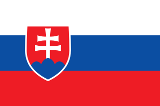
Slovakia, officially the Slovak Republic, is a landlocked country in Central Europe. It is bordered by Poland to the north, Ukraine to the east, Hungary to the south, Austria to the west, and the Czech Republic to the northwest. Slovakia's mostly mountainous territory spans about 49,000 square kilometres (19,000 sq mi), hosting a population exceeding 5.4 million. The capital and largest city is Bratislava, while the second largest city is Košice.
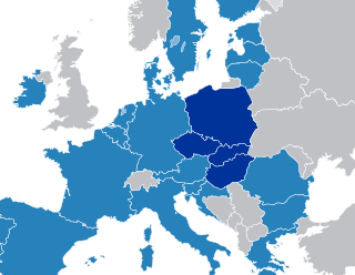
The Visegrád Group is a cultural and political alliance of four Central European countries: the Czech Republic, Hungary, Poland, and Slovakia. The alliance aims to advance co-operation in military, economic, cultural and energy affairs, and to further their integration with the EU. All four states are also members of the European Union (EU), the North Atlantic Treaty Organization (NATO), and the Bucharest Nine (B9).

Burgenland is the easternmost and least populous state of Austria. It consists of two statutory cities and seven rural districts, with a total of 171 municipalities. It is 166 km (103 mi) long from north to south but much narrower from west to east. The region is part of the Centrope Project. The name of Burgenland was invented/coined in 1922, after its territories became part of Austria.

Lower Austria is one of the nine states of Austria, located in the northeastern corner of the country. Since 1986, the capital of Lower Austria has been Sankt Pölten, replacing Vienna, which became a separate state in 1921. With a land area of 19,186 km2 (7,408 sq mi) and a population of 1.685 million people, Lower Austria is the second-most-populous state in Austria. Other large cities are Amstetten, Klosterneuburg, Krems an der Donau, Stockerau and Wiener Neustadt.
Europe, the westernmost portion of Eurasia, is often divided into regions and subregions based on geographical, cultural or historical factors. Since there is no universal agreement on Europe's regional composition, the placement of individual countries may vary based on criteria being used. For instance, the Balkans is a distinct geographical region within Europe, but individual countries may alternatively be grouped into South-eastern Europe or Southern Europe.
Győr-Moson-Sopron is an administrative county in north-western Hungary, on the border with Slovakia and Austria (Burgenland). It shares borders with the Hungarian counties Komárom-Esztergom, Veszprém and Vas. The capital of Győr-Moson-Sopron county is Győr. The county is a part of the Centrope Project.

The Trnava Region is one of the eight Slovak administrative regions. It was established in 1996, before which date, most of its districts were parts of Bratislava Region which was established on the founding of Czechoslovakia in 1923. It consists of 251 municipalities, from which 16 have a town status. It is the second most densely populated region in Slovakia.

The Bratislava Region is one of the administrative regions of Slovakia. Its capital is Bratislava. The region was first established in 1923 and its present borders exist from 1996. It is the smallest of the eight regions of Slovakia as well as the most urbanized, most developed and most productive by GDP per capita.

The economy of the European Union is the joint economy of the member states of the European Union (EU). It is the second largest economy in the world in nominal terms, after the United States, and the third largest at purchasing power parity (PPP), after China and the US. The European Union's GDP is estimated to be $19.35 trillion (nominal) in 2024 or $26.64 trillion (PPP), representing around one-sixth of the global economy. Germany has the biggest national GDP of all EU countries, followed by France and Italy.

The Pannonian Basin, or Carpathian Basin, is a large sedimentary basin situated in southeast Central Europe. After the WW1 and Treaty of Trianon, the geomorphological term Pannonian Plain became more widely used for roughly the same region though with a somewhat different sense, with only the lowlands, the plain that remained when the Pliocene Epoch Pannonian Sea dried out.

The United States of Greater Austria was an unrealised proposal made in 1906 to federalize Austria-Hungary to help resolve widespread ethnic and nationalist tensions. It was conceived by a group of scholars surrounding Archduke Franz Ferdinand of Austria, notably by the ethnic Romanian lawyer and politician Aurel Popovici.

The Košice Region is one of the eight Slovak administrative regions. The region was first established in 1923 and its present borders were established in 1996. It consists of 11 districts (okresy) and 440 municipalities, 17 of which have a town status. About one third of the region's population lives in the agglomeration of Košice, which is its main economic and cultural centre.
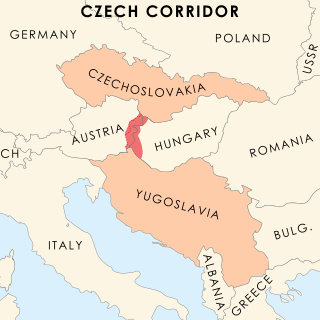
The Czech Corridor or Czechoslovak Corridor was a failed proposal during the Paris Peace Conference of 1919 in the aftermath of World War I and the breakup of Austria-Hungary. The proposal would have carved out a strip of land between Austria and Hungary to serve as a corridor between two newly formed Slavic countries with shared interests, the Kingdom of Serbs, Croats and Slovenes (Yugoslavia) and Czechoslovakia. A different name often given is Czech–Yugoslav Territorial Corridor. It is primarily referred to as "the Czech Corridor" today, because representatives of Yugoslavia at the Peace Conference stated that they would prefer it if the corridor were to be controlled solely by Czechoslovaks. The proposal was ultimately rejected by the conference and never again suggested.
The First Czechoslovak Republic, often colloquially referred to as the First Republic, was the first Czechoslovak state that existed from 1918 to 1938, a union of ethnic Czechs and Slovaks. The country was commonly called Czechoslovakia, a compound of Czech and Slovak; which gradually became the most widely used name for its successor states. It was composed of former territories of Austria-Hungary, inheriting different systems of administration from the formerly Austrian and Hungarian territories.
The following outline is provided as an overview of and topical guide to Slovakia:
East-Central Europe is the region between German-, Hungarian-, and West Slavic-speaking Europe and the East Slavic countries of Belarus, Russia, and Ukraine. Those lands are described as situated "between two": "between two worlds, between two stages, between two futures".

Bratislava, historically known as Preßburg (Pressburg), is the capital and largest city of Slovakia and the fourth largest of all cities on Danube river. Officially, the population of the city is about 475,000; however, some sources estimate it to be more than 660,000—approximately 140% of the official figures. Bratislava is in southwestern Slovakia at the foot of the Little Carpathians, occupying both banks of the River Danube and the left bank of the River Morava. Bordering Austria and Hungary, it is the only national capital to border two sovereign states.
