Changning, Hunan

Last updated
Changning
常宁市
ChinaHengyangChangning.png
Location in Hengyang
Location map China Hunan EN.svg
Red pog.svg
Changning
Location in Hunan
Coordinates: 26°25′20″N112°24′00″E / 26.4220895759°N 112.3998822948°E / 26.4220895759; 112.3998822948
Country People's Republic of China
Province Hunan
Prefecture-level city Hengyang
Divisions4 townships, 14 towns and 3 subdistricts
Establishment257 AD
government seat Yiyang Subdistrict
Area
   County-level city 2,046.6 km2 (790.2 sq mi)
  Land1,959.8 km2 (756.7 sq mi)
  Water86.8 km2 (33.5 sq mi)
  Urban
[1]
38.40 km2 (14.83 sq mi)
Population
 (2010 census)
   County-level city 810,447
  Estimate 
(2017)
990,000
  Density400/km2 (1,000/sq mi)
   Urban
[1]
240,000
  [2]
Time zone UTC+8 (China Standard)
Area code 0734
Languages Mandarin and Gan Chinese
Website hnchangning.gov.cn

Changning [lower-alpha 1] is a county-level city in Hunan Province, China, under the administration of Hengyang prefecture-level City. Located on the south-central part of the province, the city is bordered to the north by Qidong and Hengnan Counties, to the east by Leiyang City, to the south by Guiyang County, to the west by Qiyang County. Changning City covers 2,046.6 km2 (790.2 sq mi) [3] with registered population of 958,988 and resident population of 810,447 (as of the 2010 census [2] ). The city has three subdistricts, 14 towns and four townships under its jurisdiction, the government seat is Yiyang Subdistrict (宜阳街道). [4]

Contents

History

Before the Zhou dynasty, Changning was part of Jingzhou. It was part of Chu State during the Warring States period, and it was the territory of Leiyang County during the Qin and Han dynasties. In the three kingdoms period, the two counties of Xinping (新平县) and Xinning (新宁县) were formed from the western side of Chongling River in the southwest of Leiyang County In 257 AD. In Jin dynasty period, the county of Xinping was merged to Xinning in 396 AD. In Tang dynasty period, the county of Xinning was renamed to Changning (the present name) in 742 AD. It was a county of Heng Precture (衡州) during the periods of Tang dynasty, five Dynasties and Song dynasty.

The county of Changning was ceased to be as a separated county, it was approved to reorganize as a county-level city of Hengyang by the State Council on November 26, 1996. [5]

Geography

Changning City is located in the south of Hunan province, the southwest of Hengyang and on the south bank of the middle reaches of Xiang River. it is bordered Leiyang City across the Chongling River to the east, Guiyang County to the south, Qiyang County to the west, counties of Qiyang and Hengnan across the Xiang River to the north. It is located between latitude 26°07'-26°36' degrees N and between longitude 112°07'-112°41'E. The city of Changing has an area of 2,046.6 square kilometers, accounting for 0.97% of Hunan and 13.37% of Hengyang. [6]

Changning has an area of 2046.6 square kilometers, including 520 square kilometers of plains, accounting for 25.41% of the total area; hills of 348 square kilometers, accounting for 17.01%; water area of 86.8 square kilometers, accounting for 4.24%. According to the natural attributes of land, 37,910 hectares of arable land, 18.52% of the total area; 91,950 hectares of forest land, accounting for 44.1%; garden area of 4,180 hectares, accounting for 2.06%.

The city's geological stratigraphy is complex, ranging from the Cambrian of the Paleozoic to the Quaternary of the Cenozoic, with the exception of the Tertiary of the Cenozoic. The rocks are dominated by sedimentary rocks, accounting for about 80% of the total. Exposed in different geological periods from the Paleozoic to the Cenozoic, the distribution of igneous rocks is relatively small. There are dozens of rock bodies exposed, covering an area of about 428 square kilometers, mainly granite, accompanied by moderately acidic granodiorite and a small amount of basic lamprophyre, basaltic rock and so on. [6]

Topography

The topography of Changning is low in the south and high in the north, it is roughly a two-step staircase. Tashan Mountain (塔山) and Dayi Mountain (大义山) in the south of the city are clusters of Nanling Mountains, and the two mountains are in the north-east and north–south directions respectively. Between the two mountains is the Mianqian - Xihu Low Flat Valley (庙前-西湖低平谷地), which is the traffic channel between Changning and Guiyang. There are 16 peaks above 1000 meters above sea level and 63 between 1000 meters to 100 meters above sea level. These mountains form the natural barrier in the south and are the first step. The terrain in the north is undulating with the plains and hills staggered. Most of them are below 200 meters above sea level, it is the second step. The territory of Changning is divided into three types of terrain: mountainous area, hilly area and plain. The area of mountains, hilly area and plain respectively account for 37.6%, 26% and 37.4% of the total area of the city. [7]

Hydrology

The water system of Changning City is complete and the river network is dense. The river runoff is mainly supplied by rainwater. The rainfall in the flood season is more concentrated and that in the non-flood season is less, the water flow in the wet and dry seasons is very different, the annual water level changes greatly. Usually the high water level appears in April–July, and the low water level appears from October to February. The level of the main stream of the Xiang River varies by 11.00-15.51 meters with an average flow of 1370 cubic meters per second, a maximum flow of 18,100 cubic meters per second, a minimum flow of 30 cubic meters per second, and an average annual flow of 48.74 billion cubic meters for many years. The trend is the same as the precipitation distribution, and the runoff is mostly concentrated in the spring and summer. The runoff from April to July accounts for more than 60% of the annual runoff. The average sediment concentration for many years is 0.1--0.5 kg/m3, the amount is lower than the tributaries. The natural water quality from the Xiang section and its tributaries such as rivers of Yi, Tan, Wu and Chongling, etc. is good, and the PH value is mostly around 7.2. [6]

Climate

In general, Changning has a humid subtropical monsoon climate with four distinct seasons. Due to the influence of the large-scale climate in the region and the complex topography of the territory, annual meteorological elements such as precipitation, air temperature and sunshine are erratic.

Climate data for Changning (1991–2020 normals, extremes 1981–2010)
MonthJanFebMarAprMayJunJulAugSepOctNovDecYear
Record high °C (°F)27.4
(81.3)
33.3
(91.9)
36.9
(98.4)
36.7
(98.1)
37.0
(98.6)
38.1
(100.6)
40.3
(104.5)
40.8
(105.4)
38.2
(100.8)
37.7
(99.9)
34.6
(94.3)
25.8
(78.4)
40.8
(105.4)
Mean daily maximum °C (°F)9.5
(49.1)
12.5
(54.5)
16.7
(62.1)
23.4
(74.1)
27.8
(82.0)
30.9
(87.6)
34.3
(93.7)
33.4
(92.1)
29.4
(84.9)
24.2
(75.6)
18.5
(65.3)
12.4
(54.3)
22.8
(72.9)
Daily mean °C (°F)6.3
(43.3)
8.8
(47.8)
12.6
(54.7)
18.8
(65.8)
23.3
(73.9)
26.7
(80.1)
29.7
(85.5)
28.6
(83.5)
24.8
(76.6)
19.6
(67.3)
14.0
(57.2)
8.4
(47.1)
18.5
(65.2)
Mean daily minimum °C (°F)4.0
(39.2)
6.2
(43.2)
9.8
(49.6)
15.4
(59.7)
19.9
(67.8)
23.6
(74.5)
26.1
(79.0)
25.2
(77.4)
21.5
(70.7)
16.3
(61.3)
10.8
(51.4)
5.6
(42.1)
15.4
(59.7)
Record low °C (°F)−4.1
(24.6)
−7.4
(18.7)
−0.5
(31.1)
2.7
(36.9)
9.1
(48.4)
13.7
(56.7)
18.4
(65.1)
18.3
(64.9)
12.8
(55.0)
4.3
(39.7)
−1
(30)
−6.3
(20.7)
−7.4
(18.7)
Average precipitation mm (inches)84.4
(3.32)
93.2
(3.67)
163.6
(6.44)
156.1
(6.15)
182.8
(7.20)
203.5
(8.01)
134.9
(5.31)
131.5
(5.18)
71.2
(2.80)
74.8
(2.94)
84.9
(3.34)
60.5
(2.38)
1,441.4
(56.74)
Average precipitation days (≥ 0.1 mm)15.615.319.016.716.714.910.512.010.410.512.111.7165.4
Average snowy days3.21.60.3000000000.75.8
Average relative humidity (%)81818279787970747676777677
Mean monthly sunshine hours 52.456.965.795.4120.5125.9218.5181.8136.4120.8105.789.41,369.4
Percent possible sunshine 16181825293152453734332831
Source: China Meteorological Administration [8] [9]

Administrative division

3 subdistricts
14 towns
4 townships

Economy

According to preliminary accounting of the statistical authority, the gross domestic product of Changning City in 2017 was 33,096 million yuan (4,897 million US dollars), up by 8.7 percent over the previous year. Of this total, the value added of the primary industry was 5,322 million yuan (787 million US dollars), up by 3.4 percent, that of the secondary industry was 12,259 million yuan (1,814 million US dollars), up by 7.9 percent and that of the tertiary industry was 15,515 million yuan (2,296 million US dollars), up by 11.5 percent. The value added of the primary industry accounted for 16.08 percent of the GDP; that of the secondary industry accounted for 37.04 percent; and that of the tertiary industry accounted for 46.88 percent. The per capita GDP in 2017 was 39,995 yuan (5,917 US dollars). [10]

Notes

  1. Chinese :常宁; pinyin :Chángníng;

Related Research Articles

<span class="mw-page-title-main">Changsha County</span> County in Hunan, Peoples Republic of China

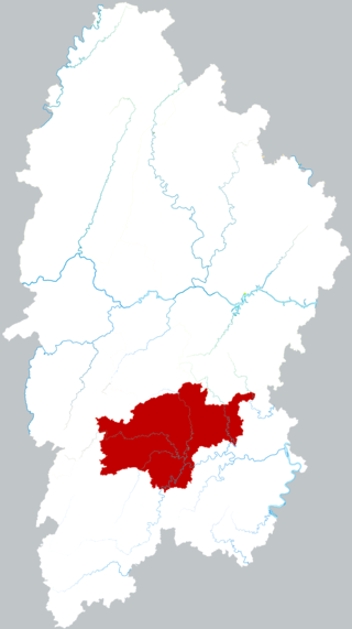
Changsha County is a county in Hunan Province, China. It is under the administration of the prefecture-level city of Changsha. Located in the west portion of Changsha, the county is bordered to the north by Miluo City and Pingjiang County, to the west by Wangcheng, Kaifu and Furong Districts, to the southwest by Yuhua District, and to the southeast and the east by Liuyang City. Changsha County covers 1,756 km2 (678 sq mi). As of 2015 it has a registered population of 743,000 and a permanent resident population of 916,000. The county has 5 subdistricts and 13 towns under its jurisdiction. The county seat is Xingsha Subdistrict (星沙街道).

<span class="mw-page-title-main">Yuelu, Changsha</span> District in Hunan, China

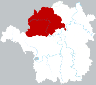
Yuelu District is one of six urban districts of the prefecture-level city of Changsha, the capital of Hunan Province, China. It is the 4th most populous district in Hunan. The district is bordered to the north by Wangcheng District, to the west by Ningxiang County, to the south by Yuhu District of Xiangtan City, across the Xiang river to the west by Tianxin, Furong and Kaifu Districts. Located on the west bank of the Xiang River, as the western part of the City proper, the district is named after Mount Yuelu, one of the national parks, Yuelu District covers 538.83 km2 (208.04 sq mi) with registered population of 644,834 and resident population of 818,900. The district has 16 subdistricts and 2 towns under its jurisdiction, its administrative centre is at Wangyue (望岳街道).

<span class="mw-page-title-main">Jishou</span> County-level city in Hunan, China

Jishou is a county-level city and the seat of Xiangxi Tujia and Miao Autonomous Prefecture, Hunan province, China.

<span class="mw-page-title-main">Zhongxiang</span> County-level City in Hubei, Peoples Republic of China

Zhongxiang is a county-level city of Jingmen, central Hubei province, People's Republic of China. The name Zhongxiang means "Blessed with propitious omen", and was given to the city by the Jiajing Emperor in the Ming dynasty.

<span class="mw-page-title-main">Leiyang</span> County-level city in Hunan, Peoples Republic of China

Leiyang is a county-level city and the third most populous county-level division in Hunan Province, China. Leiyang is under the administration of the prefecture-level city of Hengyang. Located on the south of the province, the city is bordered to the north by Hengnan County, to the west by Changning City, to the south by Guiyang and Yongxing counties, to the east by Anren County. Leiyang City covers 2,656 km2 (1,025 sq mi) with registered population of 1,413,913 and resident population of 1,150,241. The city has six subdistricts, 19 towns and five townships under its jurisdiction, the government seat is Caizichi Subdistrict.

Changning may refer to:

<span class="mw-page-title-main">Jingning She Autonomous County</span> Autonomous county in Zhejiang, Peoples Republic of China

Jingning She Autonomous County is an autonomous county for the She people, under the jurisdiction of the prefecture-level city of Lishui in the south of Zhejiang Province, China.

<span class="mw-page-title-main">Linquan County</span> County in Anhui, China

Linquan County is a county in the northwest of Anhui Province, China, bordering Henan province to the northwest, west, and southwest. It is the westernmost county-level division of Fuyang city. The Quan River 泉河 a tributary of the Ying River flows from its source in Henan province, through the county seat in Chengguan and then along the county's northern border with Jieshou. According to the 2010 census, the population was 1,543,218, the area is 702 sq mi (1,820 km2). Linquan is the most populous rural county in China.

<span class="mw-page-title-main">Shigu, Hengyang</span> District in Hunan, Peoples Republic of China

Shigu District is an urban district of Hengyang City, Hunan province, China. The district is located in the middle north of the city proper, it is bordered by Zhuhui District to the east, Yanfeng District to the south, Zhengxiang District to the west, Hengyang County to the north. Shigu District covers 112 km2 (43 sq mi), as of 2015, it had a permanent resident population of 231,700. The district has seven subdistricts and a township under its jurisdiction, the government seat is at Huangshawan Subdistrict (黄沙湾街道).

<span class="mw-page-title-main">Hengyang County</span> County in Hunan, Peoples Republic of China

Hengyang County is a county and the 5th most populous county-level division in the Province of Hunan, China; it is under the administration of Hengyang prefecture-level city. Located in the north of Hengyang City and the south east of Hunan province, the county is bordered to the north by Shuangfeng County, to the west by Shaodong County, to the south by the counties of Qidong and Hengdong and the districts of Zhengxiang, Shigu and Zhuhui, to the east by Nanyue District and Hengshan County. Hengyang County covers 2,558.61 km2 (987.88 sq mi) with a population of 1,235,100. The county has 17 towns under its jurisdiction, the county seat is Xidu Town (西渡镇).

<span class="mw-page-title-main">Hengnan County</span> County in Hunan, Peoples Republic of China

Hengnan County is a county located in the south of Hengyang prefecture-level city, Hunan province, China. It was established in 1952 and named after the south of Mount Heng. The county has an area of 2,621.1 km2 (1,012.0 sq mi) with a population of 1,069,800. The county of Hengnan has one township and 21 towns under its jurisdiction, its seat is the town of Yunji (云集镇).

<span class="mw-page-title-main">Hengshan County</span> County in Hunan, Peoples Republic of China

Hengshan County is a county in the Province of Hunan, China and it is under the administration of Hengyang prefecture-level city. Located in the north of Hengyang and the east-central part of Hunan province, the county is bordered to the north by Xiangtan County, to the northwest by Shuangfeng County, to the southwest and south by Hengyang County, Nanyue District and Hengnan County, to the east by Hengdong County. The county of Hengshan covers 934 km2 (361 sq mi) with a population of 449,500. It has five townships and seven towns under its jurisdiction, the county seat is Kaiyun Town (开云镇).

<span class="mw-page-title-main">Qidong County</span> County in Hunan, Peoples Republic of China

Qidong County is a county and the 8th most populous county-level division in the Province of Hunan, China; it is under the administration of Hengyang prefecture-level city. The county was formed from the eastern part of Qiyang County in April 1952 and was named after the east of Qiyang. Qidong County covers 1,872 km2 (723 sq mi), as of 2015, it had a registered population of 1,067,000. The county has four subdistricts, 17 towns and three townships under its jurisdiction, the county seat is Hongqiao Subdistrict (洪桥街道).

Guiyang County is a county in Hunan Province, China, it is under the administration of Chenzhou prefecture-level City.

<span class="mw-page-title-main">Ningyuan County</span> County in Hunan, Peoples Republic of China

Ningyuan County is a county of Hunan Province, China, it is under the administration of Yongzhou prefecture-level City.

Qiyang is a county-level city of Hunan Province, China. It is under the administration of the prefecture-level city of Yongzhou.

<span class="mw-page-title-main">Shaodong</span> County-level city in Hunan, Peoples Republic of China

Shaodong is a county-level city in the Province of Hunan, China, it is under the administration of Shaoyang City. ShaoDong is located in the central part of Hunan Province, covering an area of 1,778 square kilometers, with a permanent population of 1.0385 million. It is renowned as the "hometown of a hundred trades," "city of commerce," and "capital of private enterprises."

The Bai River, also known as Baisui River, is a right-bank tributary of the middle Xiang River and one of main tributaries of the Xiang in Hunan Province. It rises in Baishui Township of Guiyang County, Hunan. Its main stream runs generally southeast to northwest through Guiyang, Changning and Qiyang counties, and it joins the Xiang in Guanzikou of Baishui Town of Qiyang. The Bai River has a length of 117 kilometres (73 mi), with its tributaries, and has a drainage-basin area of 1,810 square kilometres (700 sq mi).

The Yishui River, also known as Yi River, is a right-bank tributary of the middle Xiang River in Hunan, China. It is the largest and longest river in Changning City. The Yi River rises in Xiaoyangquan of Baishui Township of Guiyang County. Its main stream runs generally south to north and joins the Xiang at Jiangkoutang of Xinhe Town. The Yi River has a length of 86 kilometres (53 mi), with its tributaries, and its drainage basin covers an area of 1,056 square kilometres (408 sq mi).

References

  1. 1 2 Ministry of Housing and Urban-Rural Development, ed. (2019). China Urban Construction Statistical Yearbook 2017. Beijing: China Statistics Press. p. 68. Archived from the original on 18 June 2019. Retrieved 11 January 2020.
  2. 1 2 the 2010 census population, according to xzqh.org (2016-01-11)
  3. "hnchangning.gov". Archived from the original on 2017-01-09. Retrieved 2017-01-08.
  4. about the divisions of Changning City (November 9, 2015), according to the result on adjustment of township-level administrative divisions of Changning City on November 9, 2015 rednet.cn: 《湖南省民政厅关于同意常宁市乡镇区划调整方案的批复》(湘民行发〔2015〕18号)
  5. xzqh.org (2016-02-19)
  6. 1 2 3 Location of Changning / 常宁地理位置 see hn changning.gov
  7. Geography of Changning / 常宁地理 see hnchangning.gov Archived 2018-04-29 at the Wayback Machine
  8. 中国气象数据网 – WeatherBk Data (in Simplified Chinese). China Meteorological Administration . Retrieved 11 June 2023.
  9. 中国气象数据网 (in Simplified Chinese). China Meteorological Administration . Retrieved 28 May 2023.
  10. according to the Statistical Communiqué of Changning City on the 2017 National Economic and Social Development / 常宁市2017年国民经济和社会发展统计公报 see hntj.gov (2018-03-13) Archived 2018-04-29 at the Wayback Machine or hengyang.gov (2018-03-13)