Firth is a word in the English and Scots languages used to denote various coastal waters in the United Kingdom, predominantly within Scotland. In the Northern Isles, it more often refers to a smaller inlet. It is linguistically cognate to fjord, which has a more constrained sense in English. Bodies of water named "firths" tend to be more common on the Scottish east coast, or in the southwest of the country, although the Firth of Clyde is an exception to this. The Highland coast contains numerous estuaries, straits, and inlets of a similar kind, but not called "firth" ; instead, these are often called sea lochs. Before about 1850, the spelling "Frith" was more common.

Cromarty is a town, civil parish and former royal burgh in Ross and Cromarty, in the Highland area of Scotland. Situated at the tip of the Black Isle on the southern shore of the mouth of Cromarty Firth, it is 5 miles (8 km) seaward from Invergordon on the opposite coast. In the 2001 census, it had a population of 719.

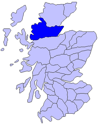
Cromartyshire is a historic county in the Highlands of Scotland, comprising the medieval "old shire" around the county town of Cromarty and 22 enclaves and exclaves transferred from Ross-shire in the late 17th century. The largest part, six times the size of the old shire, is Coigach, northwest from Ullapool. In 1890, Cromartyshire was merged with Ross-shire into the administrative county of Ross and Cromarty, which in 1975 was merged into the new council area of Highland.

The Cromarty Firth is an arm of the Moray Firth in Scotland.

The Pentland Firth is a strait which separates the Orkney Islands from Caithness in the north of Scotland. Despite the name, it is not a firth.

The Moray Firth is a roughly triangular inlet of the North Sea, north and east of Inverness, which is in the Highland council area of north of Scotland. It is the largest firth in Scotland, stretching from Duncansby Head in the north, in the Highland council area, and Fraserburgh in the east, in the Aberdeenshire council area, to Inverness and the Beauly Firth in the west. Therefore, three council areas have Moray Firth coastline: Highland to the west and north of the Moray Firth and Highland, Moray and Aberdeenshire to the south. The firth has more than 800 kilometres of coastline, much of which is cliff.

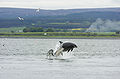
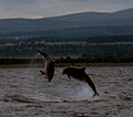
Fortrose is a town and former royal burgh in Highland, Scotland, United Kingdom. It is on the Moray Firth, about 6 miles (10 km) north-east of Inverness. The burgh is a popular location for trying to spot bottlenose dolphins in the Moray Firth. The town is known for its ruined 13th century cathedral, and as the home of the Brahan Seer.
Ross is a region of Scotland. One of the provinces of Scotland from the 9th century, it gave its name to a later earldom and to the counties of Ross-shire and, later, Ross and Cromarty. The name Ross allegedly derives from a Gaelic word meaning "headland", perhaps a reference to the Black Isle. Another possible origin is the West Norse word for Orkney – Hrossey – meaning horse island; the area once belonged to the Norwegian earldom of Orkney. Ross is a historical comital region, perhaps predating the Mormaerdom of Ross. It is also a region used by the Kirk, with the Presbytery of Ross being part of the Synod of Ross, Sutherland and Caithness.

Whale and Dolphin Conservation (WDC), formerly Whale and Dolphin Conservation Society in the UK, is a wildlife charity that is dedicated solely to the worldwide conservation and welfare of all whales, dolphins and porpoises (cetaceans). It has offices in the UK, North America, Germany and Australia.
The Black Isle is a peninsula within Ross and Cromarty, in the Scottish Highlands. It includes the towns of Cromarty and Fortrose, and the villages of Culbokie, Jemimaville, Rosemarkie, Avoch, Munlochy, Tore, and North Kessock, as well as numerous smaller settlements. About 12,000 people live on the Black Isle, depending on the definition.

Rosemarkie is a village on the south coast of the Black Isle peninsula in Ross-shire, northern Scotland.

Tarbat is a civil parish in Highland, Scotland, in the north-east corner of Ross and Cromarty.
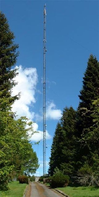
The Mounteagle transmitting station is a broadcasting and telecommunications facility, situated close to the town of Fortrose, Scotland, in Highland. It includes a 243.8 metres (800 ft) high guyed steel lattice mast. It is owned and operated by Arqiva.
Rockfield is a hamlet in the parish of Tarbat, on the Tarbat Peninsula, near the village of Portmahomack, Easter Ross, Highland, Scotland. There is a small stone jetty and the traditional way of life included fishing and agriculture. Rockfield is generally east-facing, below the level of a raised beach.
Nigg Bay is a large, relatively shallow sandy bay, consisting of mudflats, saltmarsh and wet grassland, located on the north east coast of the Cromarty Firth, 5 miles (8 km) east of Invergordon, in the district of Ross and Cromarty and in the Scottish council area of Highland. At low tide, the Sands of Nigg are exposed. Nigg Bay can be said to start at Balintraid pier – probably the oldest pier on the Cromarty Firth – built by Thomas Telford in 1821. There is a wartime mining base alongside the pier and a series of coastal gun emplacements on the road to North Sutor.

Yell Sound is the strait running between Yell and Mainland, Shetland, Scotland. It is the boundary between the Mainland and the North Isles and it contains many small islands. Sullom Voe, on the shores of which is a substantial oil terminal, is an arm of Yell Sound.
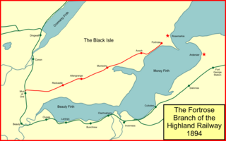
The Fortrose Branch, also known as the Black Isle Railway, was a railway branch line serving Fortrose in the Black Isle, in the north of Scotland. It was built by the Highland Railway as a tactical measure to exclude a rival railway company and to move the locals from Fortrose onwards to other destinations.
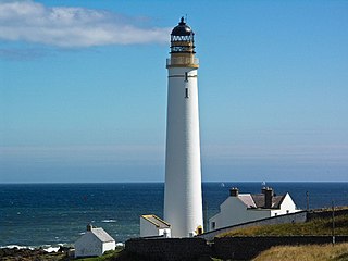
Scurdie Ness is a headland located on the South side of the River South Esk estuary, Montrose, Angus, Scotland. The River leads from the North Sea into Montrose Harbour and then into Montrose Basin. The headland has also been referred to as Scurdy Ness, Montrose point or Montroseness. The word Scurdie is a local word for the volcanic rock found there and Ness means a promontory, cape or headland. The coastline from Scurdie Ness to Rickle Craig has been designated a Site of Special Scientific Interest.

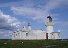
Fortrose Cathedral was the episcopal seat (cathedra) of the medieval Scottish diocese of Ross in the Highland region of Scotland. It is probable that the original site of the diocese was at Rosemarkie, but by the 13th century the canons had relocated a short distance to the south-west, to the site known as Fortrose or Chanonry. According to Gervase of Canterbury, in the early 13th century the cathedral of Ross was manned by Céli Dé (culdees).
The Rosemarkie transmitting station is a broadcasting and telecommunications facility, situated close to the town of Rosemarkie, Scotland, in Highland. It consists of a 110 metres (361 ft) high guyed steel lattice mast erected on land that is itself about 210 m above sea level only a few hundred metres from the coast of the Moray Firth. It is owned and operated by Arqiva.