
Calvert County is located in the U.S. state of Maryland. As of the 2020 census, the population was 92,783. Its county seat is Prince Frederick. The county's name is derived from the family name of the Barons of Baltimore, the proprietors of the English Colony of Maryland Calvert County is included in the Washington–Arlington–Alexandria, DC–VA–MD–WV Metropolitan Statistical Area. It occupies the Calvert Peninsula, which is bordered on the east by Chesapeake Bay and on the west by the Patuxent River. Calvert County is part of the Southern Maryland region. The county has one of the highest median household incomes in the United States. It is one of the older counties in Maryland, after St. Mary's, Kent County and Anne Arundel counties.
St. Mary's County, established in 1637, is a county located in the U.S. state of Maryland. As of the 2020 census, the population was 113,777. Its county seat is Leonardtown. The name is in honor of Mary, the mother of Jesus. St. Mary's County comprises the California-Lexington Park, Maryland Metropolitan Statistical Area, which also is included in the Washington-Baltimore-Arlington, DC-MD-VA-WV-PA Combined Statistical Area. It is part of the Southern Maryland region. The county was the home to the first Maryland Colony, and the first capitol of the Colony of Maryland. Settled by English Catholics, it is considered to be the birthplace of religious freedom in North America, at a time when the British colonies were settled primarily by Protestants. The county is home to the Patuxent River Naval Air Station and St. Mary's College of Maryland. Traditionally, St. Mary's County has been known for its unique and historic culture of Chesapeake Bay tidewater farming, fishing, and crabbing communities. But with the advent of the military bases, growth of an extensive defense contractor presence, and the growth of St. Mary's College of Maryland, as well as increasing numbers of long-distance Washington, D.C. commuters, it has been undergoing a decades-long transformation which has seen the county's population double since 1970.

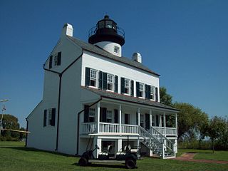
Solomons, also known as Solomons Island, is an unincorporated community and census-designated place (CDP) in Calvert County, Maryland, United States. The population was 2,368 at the 2010 census, up from 1,536 in 2000. Solomons is a popular weekend destination spot in the Baltimore–Washington metropolitan area.

Leonardtown is a town in and the county seat of St. Mary's County, Maryland, United States. The population was 4,563 at the 2020 census. Leonardtown is perhaps most famous for the national oyster-shucking championship that is held annually at the St. Mary's County fairgrounds.

Lexington Park is a census-designated place (CDP) in St. Mary's County, Maryland, United States, and the principal community of the Lexington Park, Maryland Micropolitan Statistical Area. The population was 11,626 at the 2010 census.

The Patuxent River is a tributary of the Chesapeake Bay in the state of Maryland. There are three main river drainages for central Maryland: the Potomac River to the west passing through Washington, D.C., the Patapsco River to the northeast passing through Baltimore, and the Patuxent River between the two. The 908-square-mile (2,352 km2) Patuxent watershed had a rapidly growing population of 590,769 in 2000. It is the largest and longest river entirely within Maryland, and its watershed is the largest completely within the state.

Southern Maryland is a geographical, cultural and historic region in Maryland composed of the state's southernmost counties on the Western Shore of the Chesapeake Bay. According to the state of Maryland, the region includes all of Calvert, Charles, and St. Mary's counties and the southern portions of Anne Arundel and Prince George's counties.

Naval Air Station Patuxent River, also known as NAS Pax River, is a United States naval air station located in St. Mary’s County, Maryland, on the Chesapeake Bay near the mouth of the Patuxent River.

St. Mary's County Public Schools is a school district that serves St. Mary's County, Maryland, USA, at the confluence of the Potomac River, Patuxent River, and Chesapeake Bay. The area is a mixture of rural and suburban communities. Many of the families are employed by NAS Patuxent River, government contractors, St. Mary's College of Maryland, county government, and others involved in the traditional agriculture and water-related businesses. It has an approximate enrollment of almost 17,000 students. SMCPS operates 18 elementary schools, 5 middle schools, 4 high schools, an Alternative Learning Center, and a Vocational Training Center, serving students in Grades Pre-K through 12th grade. The school system is overseen by the Maryland State Department of Education.

Major Thomas Brooke Sr., Esq. was a colonial lawyer, planter and politician of Calvert County, Maryland, where he served in the appointed positions of Burgess, High Sheriff and Chief Justice.
Fulton is a census-designated place located in southern Howard County, Maryland, United States. As of the 2010 census it had a population of 2,049.

Maryland Route 234 (MD 234) is a state highway in the U.S. state of Maryland. Known as Budds Creek Road, the state highway runs 19.02 miles (30.61 km) from U.S. Route 301 (US 301) in Allens Fresh east to MD 5 in Leonardtown. MD 234 is the primary east–west highway of southern Charles County and western St. Mary's County, connecting the St. Mary's County seat of Leonardtown and the communities of Clements, Chaptico, Budds Creek, Wicomico, and Newport with US 301, which heads north to La Plata, the county seat of Charles County, and south to the Governor Harry W. Nice Memorial Bridge over the Potomac River.
Bristol is an unincorporated community in Anne Arundel County, Maryland, United States. Jug Bay Wetlands Sanctuary and the colonial town of Pig Point are on the Patuxent River waterfront portion of Bristol. Pig Point saw War of 1812 action and was the county's largest steamboat port on the Patuxent in the mid-19th century. Pig Point is a very significant Native American Early Archaic Period archaeological site.

Chaptico is an unincorporated community in St. Mary's County, Maryland, United States. It lies on Chaptico Run, which forms a bay as it enters the Wicomico River.
The Patuxent or Pawtuxent were one of the Native American tribes living along the western shore of the Chesapeake Bay. They spoke an Algonquian language and were loosely dominated by the Piscataway.

The Patuxent Research Refuge is a National Wildlife Refuge in Prince George's County, Maryland, United States, established in 1936 by executive order of President Franklin D. Roosevelt. It is the only National Wildlife Refuge in the country established to support wildlife research. With land surrounding the Patuxent and Little Patuxent Rivers between Washington, D.C. and Baltimore, Maryland, the refuge has grown from the original 2,670 acres (10.8 km2) to its present size of over 12,800 acres (52 km2) and encompasses land formerly managed by the Departments of Agriculture and Defense. Throughout decades of change, Patuxent's mission of conserving and protecting the nation's wildlife and habitat through research and wildlife management techniques has remained virtually unchanged.

Maryland Route 237 is a state highway in the U.S. state of Maryland. Known as Chancellors Run Road, the route runs 2.95 miles (4.75 km) from MD 246 near Lexington Park north to MD 235 in California. MD 237, which was designated in the mid-1980s, bypasses the center of Lexington Park through the suburban area surrounding Naval Air Station Patuxent River. The state highway was expanded to a four-lane divided highway between 2008 and 2010 in response to increased activity at the military base.

Mattaponi, also known as the John Bowie Jr. House, is a historic home in Croom, Maryland, built c. 1820 on the foundation of an earlier house dating to the 1730s, three miles northwest of Nottingham, Prince George's County, Maryland.