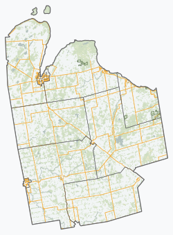
The current township was formed in late year 2000 with the amalgamation of Holland Township, Sullivan Township, and the village of Chatsworth.[5] The first white settlers arrived in this area in the early 19th century, and a significant amount of settlement was underway in mid-to-late 1800s.[6]:1
The Canadian suffragette and activist Nellie McClung was born in the town of Chatsworth.[7]
The township is led by a municipal council consisting of a Mayor, a Deputy Mayor and three Council Members. The current Council, elected in 2018, comprises Scott Mackey as Mayor; Brian Gamble as Deputy mayor; and Shawn Greig, Elizabeth Thompson and Diana Rae as Councillors.[8]
Communities
In addition to the town of Chatsworth itself, the township comprises the communities of Arnott, Berkeley, Desboro, Dornoch, Glascott, Grimston, Harkaway, Hemstock Mill, Holford, Holland Centre, Keady, Keward, Kinghurst, Lily Oak, Lueck Mill, Marmion, Massie, Mooresburg, Mount Pleasant, Peabody, Scone, Strathaven, Walters Falls, Williams Lake, and Williamsford.
Arnott
Arnott's first post office opened on January 4, 1868.[6]:155 Arnott's location has not been shown on road maps since 1976 when Highway 10 was surveyed and rerouted.[6]:153 Arnott had a population of 70 in 1864; it was approximately 50 in 1887. The hamlet was originally called "Murray's Corner" but was renamed "Arnott" after a Francis Arnott who was given a grant to settle the area.[9]
Berkeley
The post office in Berkeley was established in 1853 when the settlement was originally called "Holland". It was renamed "Berkeley" in 1857. The post office also housed the general store which operated under various proprietors until 1974 when it was phased out of operation.[6]:159
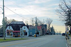
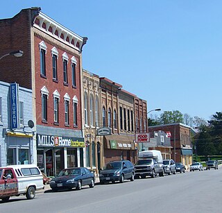
Inside the township of Chatsworth[10] sits the village of Chatsworth, Ontario where Highways 6 and 10 meet and continue together to Owen Sound. Chatsworth was settled in 1842 when a man named Coyer built a tavern.[6]:166
Chatsworth had a weekly newspaper called "Chatsworth News" which ran from 1885 to 1935. It had a competitor called "Chatsworth Banner" which was also weekly and ran from 1896 to 1907.[6]
Recreation
Chatsworth featured a hockey arena which closed on 30 September 2017.
The half-century-old Chatsworth Community Centre closed for good on 30 September 2017
Chatsworth Township Mayor Bob Pringle said the costs to deal with the building's structural issues, which were outlined in an April 2017 report by GM BluePlan engineers, and to bring the arena up to today's standards are not financially feasible for the township.
He said council unanimously approved a motion to shutter the facility Wednesday.
"The engineer's report pointed out some deficiencies that needed to be addressed for public safety. And then council with staff had to find some costs and come to some hard decisions and recommendations. The decision was made that it would close,
Source: Owen Sound Suntimes
As well a baseball diamond. It is home to the local Chatsworth Rebels.
Desboro
The village of Desboro saw its first building in 1856. It was a log school house. The area was originally called Brown's Corners. At some point its name was changed to Donnybrook and then to Desborough after a village in central England. The first house and store were built in 1866 by George Smith. The Desboro hotel was built in 1869 and was one of the only rural taverns still operating in the township before it closed in 2011. The town hall was built in 1875 and enlarged to a two-storey building in 1950.[11]
Desboro is about 13 kilometres west of Chatsworth and Williamsford.
Recreation
Desboro[12] features a modern hockey arena which was built in 1956 and has since been significantly renovated. The community grounds also contains two baseball diamonds.
The village of Dornoch was settled by Bartholomew Griffin in 1841 when he encountered a crossroads that appealed to him. The area was originally called "Griffin's Corners" after Griffin started the first general store. In the late 1850s the village was served by a stage coach that was running between Durham and Chatsworth. Around the turn of the century, the name was changed to Dornoch after the village in northern Scotland. The community centre was built in 1952 and still serves Dornoch.[6]:164
Dornoch is situated between Williamsford and Durham on Highway 6 and is 33 kilometers south of Owen Sound.
Harkaway
The Harkaway post office was established on May 1, 1875. It was closed in 1913 after rural mail delivery started in the area.[6]:167
Harkaway is 10 kilometres east of Holland Centre.
Holland Centre
In the 1870s, local farmers got together under the leadership of Alfred Williams and got a railway station built. Williams built a general store. With well-travelled roads and a railway station, Holland Centre was well established as a lumber town.[6]:13,170 It was named 'Williamsford' after the prominent resident, but with another village bearing the same name only a few miles away, it was changed to 'Holland Centre' because of its location at the centre of Holland Township.[6]:204–206
The village sits on Highway 10 and is about 10 kilometres southeast of Chatsworth.
Recreation
Holland Centre features a community centre and a baseball diamond. The diamond is home to the Hawks (youth softball), and men's and ladies' Slow pitch. There is a hardball-like diamond on the other side; however, it rarely gets used and only for the youth tournaments. The Holland Center Hall is just beside the diamond.
Keady
Keady saw its first settlers in the 1850s. The original general store was built in the late 1860s and operated for almost 100 years before being converted into a residence.[13]
Keady is well known in the region for its popular farmers market.[14]
Lily Oak
Lily Oak is a farming community. The post office was closed in 1914 when rural mail delivery was started.[6]
Lily Oak is about 8 kilometres east of Holland Centre.
Massie
The hamlet of Massie sits in the valley of the Bighead River and had settlers in the area in the 1840s.[6]:176 Charles Winter bought 200 acres in 1854 and the land was apportioned to various people after that. The sawmill was built in 1859 and the grist mill was built in 1863. By 1866 it also had a post office, blacksmith shop, horse shoe nail factory and a school house. There were approximately 100 people living in Massie in 1887.[6]:177
Massie sits on Massie Road between Chatsworth and Walters Falls.
Strathaven
The hamlet of Strathaven was developing in the 1850s and in 1887 had a population of about 50 people.[6]:184
Strathaven is about 6 kilometres west of Walters Falls.
Walters Falls
Walters Falls - view from below
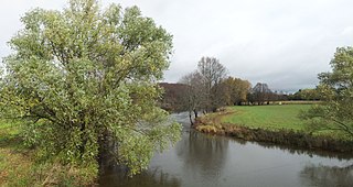
Walters Falls[15] was founded in 1852 when John Walter of Toronto took up 300 acres of wild land on the south branch of the Bighead River. Walter set up a sawmill in 1853 with a new one being erected in 1864. This mill operated inside the village of Walters Falls which built up around it. By 1865 the town was served by a grist mill, a woolen mill, a post office, a tavern, a blacksmith, a wagon maker, two carpenters, a millwright and a tinsmith.[6]:189 There is conflicting information on page 149 of 'The Paths that Led to Holland' which states that "John Walter and his Wife Elizabeth Payne, filed entry in the District Registry Office in Durham in 1850 for 800 acres that built mills which included a grist mill, carding and saw mill."[6]:149
In 1882–83 the first general store was opened in the village.
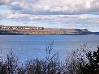
The main sawmill in the village was purchased by the Hallman family in 1944 and rebuilt after it had lain mostly idle for 22 years.[6]:151 It burned down on October 15, 1984[16] and was still utilizing a water-driven turbine up to that point to provide one-third of its energy. The fire was likely caused by an electrical accident. A new facility was rebuilt on the outskirts of the village and started operations in March 1986.[17][18] The original sawmill was used for storage until the early 2000s when the remaining building was demolished and an inn[19] was built in its place. The area surrounding the inn features a river, a dam, a large waterfall and a forest with outcroppings of the Niagara Escarpment. The area is maintained in a picturesque condition and is considered a local tourist attraction. The waterfall is just one of many in Grey County.[20]
In the mid-1850s, John Walter also set up the feed mill which is still in operation as Walters Falls Milling Ltd., still operating on water driven machinery most of the year with a diesel engine.[6]:150 It suffered a fire in 1923 and was rebuilt on the same site.[6]:142[21]
The village had a population of about 200 people in 1887.[6]
Surrounded by rolling farmland and bush, Walters Falls also sees the Bruce Trail running along the Bighead River through the bush behind the Falls Inn.
Walters Falls Community Centre
The Community Centre Hall was built over the period of 1883–1889.[6]:194 Gas lights were installed in 1923 and were replaced in 1931 when the hall was wired for electricity at a cost of $137.50. The wall behind the stage was painted by local artist Garnet Hazard in 1948 and has become an iconic fixture of the hall. It took almost 15 years for the residents of Walters Falls to convince the hall board that indoor plumbed washrooms were necessary so they finally succumbed and had them constructed in 1975.
The residents of Walters Falls celebrated the 100th birthday of the community centre on July 8, 1989. There was a parade, a horseshoe tournament and a baseball game. The evening included a concert.[22]
Williams Lake
Williams Lake is a popular lake for fishing and boating in Chatsworth Township sitting between Williamsford and Holland Centre.[6]:199 It is a 148-acre[23] clover-shaped body of water which was named after the Williams family that owned a large portion of the lake. It has a distinctive clover shape and features a public beach with boat launch which is located amongst the approximately 60 homes and cottages built on the shore of the lake.[6]:200[23] The first cottage built was on an island in 1948.
In 1973, a large portion on the southeast side was preserved as natural land when it was purchased by the North Grey Conservation Authority.[6]
A railroad was built to Williams Lake in 1899 in order to dig up the grey muck known as 'marl' which is prominent at the lake. The marl was excavated for the use of three cement plants in nearby Owen Sound as an ingredient for their product. The process of excavating the marl caused the water supply to dry up and several wells had to be dug on nearby farms by the excavation company.
The Glendale Yacht Club sits on private property at the north side of the lake which they moved to in 1984 after using leased property for the prior 30 years. There is a well-equipped club house, boat docks, a beach, and camp sites.[24]
The village of Williamsford was first surveyed in 1858 comprising 400 acres in preparation for a railway which was to run from Toronto to Owen Sound. Each township was to contribute $40,000 to its construction. The post office was built in 1847 and the general store was built in the late 1800s.[6]
Recreation
At the south end of the village sit the community centre grounds. The grounds contain a playground, a baseball diamond and a newly built curling rink.[27] The curling rink which was completed in 2010 consists of a lounge and two rinks.
The community was previously served by a hockey arena with the original attached curling rink. The arena was planned in 1954 and opened officially in 1956[6]:207 and was torn down in 2008.[28]
In the 2021 Census of Population conducted by Statistics Canada, Chatsworth had a population of 7,080 living in 2,699 of its 3,094 total private dwellings, a change of 6.8% from its 2016 population of 6,630. With a land area of 594.44km2 (229.51sqmi), it had a population density of 11.9/km2 (30.8/sqmi) in 2021.[32]
Hungerford's crawling water beetle
A short stretch of the North Saugeen River just over the Bruce County border at the Chatsworth community of Scone is home to one of the most critically endangered of all insects: the Hungerford's crawling water beetle. The only known population of Hungerford's crawling water beetles outside of the United States was discovered near there in 1986 when 42 beetles were identified at a site downstream from the community's dam. An unspecified number of beetles were last recorded in 2001, but surveys in 2002 uncovered no specimens. As a result, the status of this population of Hungerford's crawling water beetles is uncertain at present. In 2011, there were no signs of the beetle.
Although the Hungerford's crawling water beetle was categorized as endangered on March 7, 1994, under the provisions of the U.S. Endangered Species Act, it is currently not protected in Canada.
Erin is a town in Wellington County, approximately 80 kilometres (50 mi) northwest of Toronto, Ontario, Canada. Erin is bordered by the Town of Caledon, Ontario to the east, the Town of Halton Hills to the south, the Township of Guelph/Eramosa to the west and the Township of East Garafraxa to the north.
West Grey is a township in the northern area of Southwestern Ontario, Canada, in Grey County spanning across the River Styx, the Rocky Saugeen River, the Beatty Saugeen River, and the South Saugeen River.
South Bruce Peninsula is a town at the base of the Bruce Peninsula of Ontario, Canada, in Bruce County between Lake Huron and Georgian Bay. It was formed on January 1, 1999, when the town of Wiarton, the village of Hepworth, and the townships of Albemarle and Amabel were amalgamated. The new municipality was created to provide necessary political representation, administrative support, and necessary municipal services on behalf of the residents.
The Saugeen River is located in southern Ontario, Canada. The river begins in the Osprey Wetland Conservation Lands and flows generally north-west about 160 kilometres (99 mi) before exiting into Lake Huron. The river is navigable for some distance, and was once an important barge route. Today the river is best known for its fishing and as a canoe route.
Bruce County is a county in Southwestern Ontario, Canada. It has eight lower-tier municipalities with a total 2016 population of 66,491. It is named for James Bruce, 8th Earl of Elgin and 12th Earl of Kincardine, the sixth Governor General of the Province of Canada. The Bruce name is also linked to the Bruce Trail and the Bruce Peninsula.
Severn is a township in south-central Ontario, Canada, located between Lake Couchiching, and the Severn River in Simcoe County.
Williamsford is a village on the North Saugeen River in Grey County, Ontario, Canada. It has a general store, Pie Company, post office, a bookstore and restaurant housed in a historic grain mill. A small dam controls the North Saugeen River. It has several churches, and a community cemetery. It is located on Highway 6 between Durham and Owen Sound.
The Bighead River is a river in Grey County in southern Ontario, Canada, that flows from the Niagara Escarpment between the communities along Ontario Highway 10 of Arnott and Holland Centre in the township of Chatsworth to empty into Nottawasaga Bay, an inlet of Georgian Bay on Lake Huron, at Meaford.
The Sauble River is a river in Bruce County and Grey County in southwestern Ontario, Canada that flows from its headwaters in the township of Chatsworth to Lake Huron north of the community of Sauble Beach.
Southampton is a community on the shores of Lake Huron in Bruce County, Ontario, Canada. It is close to Port Elgin and is located at the mouth of the Saugeen River in the Saugeen Ojibway Nation Territory. The size of the town is 6.44 square kilometres. The permanent population in 2016 was 3,678, but the summer population is higher since cottagers and campers spend vacation time in the area.
Meaford is a municipality in Grey County, Ontario, Canada located on Nottawasaga Bay, a sub-basin of Georgian Bay and Owen Sound Bay, in the traditional territory of the Saugeen Ojibway Nation in southern Ontario. The municipality's seal and motto reflect its heritage as a place of apple orchards, but in the 21st century the area has partly switched to weekend homes, seasonal homes, and lakeside tourism.
Tara is an unincorporated community in the municipality of Arran–Elderslie, Bruce County, in southwestern Ontario, Canada. It is a designated place and had 1,037 residents and 458 dwellings as of the 2011 census. Tara is in geographic Arran Township and is located on the Sauble River. It has an area of 2.39 square kilometres (0.92 sq mi) and an urban area that covers 63.5 square kilometres (24.5 sq mi).
Saugeen Shores is a town in Bruce County, Ontario, Canada, formed in 1998. In addition to the two main population centres of Southampton and Port Elgin, the town includes a portion of the village of Burgoyne and the North Bruce area, straddling the municipal eastern and southern boundary respectively. In 2016, the permanent population of Saugeen Shores was 13,715, in a land area of 171.05 square kilometres (66.04 sq mi).
Port Elgin is a community in Bruce County, Ontario, Canada. Its location is in the traditional territory of the Saugeen Ojibway Nation. Originally named Normanton the town was renamed Port Elgin when it was incorporated in 1874, after James Bruce, 8th Earl of Elgin, a former Governor General of the Province of Canada.
Durham is a community in the municipality of West Grey, Grey County, Ontario, Canada. Durham is located near the base of the Bruce Peninsula.
Teeswater is a community in the municipality of South Bruce, Bruce County, Ontario, Canada. It is located 12 kilometres west of Mildmay, 16 kilometres north of Wingham on County Road 4, and 25 kilometres southeast of Ripley on Bruce Road 6. The population in 2016 was 995.
The village of Dornoch is located less than 11 kilometers north of the Town of Durham on Highway 6 in Grey County, Ontario, Canada. It is part of the municipality of West Grey.
Chatsworth is a community in Grey County, Ontario, Canada, part of the Township of Chatsworth. It is located south of Owen Sound and north of Durham where Highways 6 and 10 merge. The village neighbours Williamsford, Dornoch, and Desboro.
Maple Hill is an dispersed rural community in the township municipality of Brockton, Bruce County, Ontario, Canada.
This page is based on this Wikipedia article Text is available under the CC BY-SA 4.0 license; additional terms may apply. Images, videos and audio are available under their respective licenses.