
Chepstow is a town and community in Monmouthshire, Wales, adjoining the border with Gloucestershire, England. It is located on the tidal River Wye, about 2 miles (3.2 km) above its confluence with the River Severn, and adjoining the western end of the Severn Bridge. It is the easternmost settlement in Wales, situated 16 miles (26 km) east of Newport, 28 miles (45 km) east-northeast of Cardiff, 18 miles (29 km) northwest of Bristol and 110 miles (180 km) west of London.

White Castle, also known historically as Llantilio Castle, is a ruined castle near the village of Llantilio Crossenny in Monmouthshire, Wales. The fortification was established by the Normans in the wake of the invasion of England in 1066, to protect the route from Wales to Hereford. Possibly commissioned by William fitz Osbern, the Earl of Hereford, it comprised three large earthworks with timber defences. In 1135, a major Welsh revolt took place and in response King Stephen brought together White Castle and its sister fortifications of Grosmont and Skenfrith to form a lordship known as the "Three Castles", which continued to play a role in defending the region from Welsh attack for several centuries.
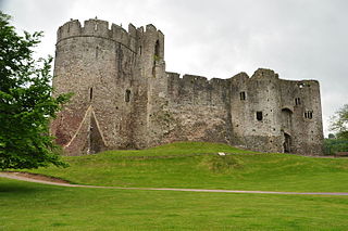
Chepstow Castle at Chepstow, Monmouthshire, Wales is the oldest surviving post-Roman stone fortification in Britain. Located above cliffs on the River Wye, construction began in 1067 under the instruction of the Norman Lord William FitzOsbern. Originally known as Striguil, it was the southernmost of a chain of castles built in the Welsh Marches, and with its attached lordship took the name of the adjoining market town in about the 14th century.
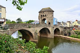
Monnow Bridge, in Monmouth, Wales, is the only remaining fortified river bridge in Great Britain with its gate tower standing on the bridge. Such bridge towers were common across Europe from medieval times, but many were destroyed due to urban expansion, diminishing defensive requirements and the increasing demands of traffic and trade. The historical and architectural importance of the bridge and its rarity are reflected in its status as a scheduled monument and a Grade I listed building. The bridge crosses the River Monnow 500 metres (1,600 ft) above its confluence with the River Wye.
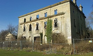
Piercefield House is a largely ruined neo-classical country house near St Arvans, Monmouthshire, Wales, about 1.5 miles (2.4 km) north of the centre of Chepstow. The central block of the house was designed in the very late 18th century, by, or to the designs of, Sir John Soane. It is flanked by two pavilions, of slightly later date, by Joseph Bonomi the Elder. The house sits within Piercefield Park, a Grade I listed historic landscape, that was created in the 18th century as a notable Picturesque estate.

Skenfrith Castle is a ruined castle in the village of Skenfrith in Monmouthshire, Wales. The fortification was established by the Normans in the wake of the invasion of England in 1066, to protect the route from Wales to Hereford. Possibly commissioned by William fitz Osbern, the Earl of Hereford, the castle comprised earthworks with timber defences. In 1135, a major Welsh revolt took place and in response King Stephen brought together Skenfrith Castle and its sister fortifications of Grosmont and White Castle to form a lordship known as the "Three Castles", which continued to play a role in defending the region from Welsh attack for several centuries.

Denbigh Castle and town walls were a set of fortifications built to control the lordship of Denbigh after the conquest of Wales by Norman King Edward I in 1282. The King granted the lands to Henry de Lacy, the Earl of Lincoln, who began to build a new walled town, colonised by immigrants from England, protected by a substantial castle and surrounded by deer parks for hunting. The work had not been completed by 1294, when the Welsh temporarily seized the castle during the Madog ap Llywelyn revolt. The defences continued to be improved, although the castle was not completely finished by the time of Henry's death in 1311.

Raglan (; is a village and community in Monmouthshire, south east Wales, United Kingdom. It is located some 9 miles south-west of Monmouth, midway between Monmouth and Abergavenny on the A40 road very near to the junction with the A449 road. The fame of the village derives from Raglan Castle, built for William ap Thomas and now maintained by Cadw. The community includes the villages of Llandenny and Pen-y-clawdd. Raglan itself has a population of 1,183.
Striguil or Strigoil is the name that was used from the 11th century until the late 14th century for the port and Norman castle of Chepstow, on the Welsh side of the River Wye which forms the boundary with England. The name was also applied to the Marcher lordship which controlled the area in the period between the Norman conquest and the formation of Monmouthshire under the Laws in Wales Acts 1535–1542.

Grosmont Castle is a ruined castle in the village of Grosmont, Monmouthshire, Wales. The fortification was established by the Normans in the wake of the invasion of England in 1066, to protect the route from Wales to Hereford. Possibly commissioned by William fitz Osbern, the Earl of Hereford, it was originally an earthwork design with timber defences. In 1135, a major Welsh revolt took place, and in response King Stephen brought together Grosmont Castle and its sister fortifications of Skenfrith and White Castle to form a lordship known as the "Three Castles", which continued to play a role in defending the region from Welsh attack for several centuries.
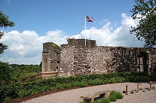
Monmouth Castle is a castle close to the centre of the town of Monmouth, the county town of Monmouthshire, on a hill above the River Monnow in south east Wales.

The Parish and Priory Church of St. Mary is located in Chepstow, Monmouthshire, south east Wales. Parts of the building, including its ornate west doorway, date from the late 11th century and are contemporary with the nearby Norman castle. The church is a Grade I listed building.

St Quintins Castle is a castle located in the village of Llanblethian, Cowbridge, Wales. It is a scheduled monument and a Grade II* listed building and is under the care of Cadw. The site was first occupied with a defensive structure in about 1102 and the gatehouse and further building work took place around 1312. It was later used as a prison and was reported as being in a ruinous state by 1741. Virtual Tour

St Mary's Priory Church, in Whitecross Street, Monmouth, Monmouthshire, Wales, is an Anglican church founded as a Benedictine priory in 1075. The current church dates mostly from the 18th and 19th centuries. It was designated a Grade II* listed building in 1952. It is one of 24 buildings on the Monmouth Heritage Trail.
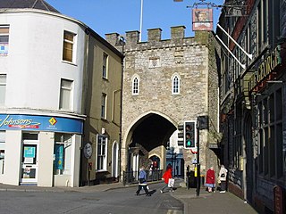
The Town Gate at Chepstow, Monmouthshire, Wales, known locally as the Town Arch, was historically the only landward entrance to the town through the Port Wall, and a point where tolls for those resorting to the town and its market were collected. It was originally built, with the wall, in the late thirteenth century. The current archway mainly dates from the sixteenth century, but has been restored and partly rebuilt on several occasions. It is located at the western end of the town's High Street, and is a Grade I listed building.
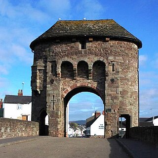
The Monmouth town walls and defences comprise the defensive system of town walls and gates built in Monmouth, Wales between 1297 and the early part of the following century. Wye Bridge Gate, East Gate, Monk's Gate, and Monnow Bridge Gate were access points to the town. West Gate, across Monnow Street, also provided access. Only the Monnow Bridge Gatehouse survives intact, albeit in a substantially modified version from the original.

Monmouthshire is a county and principal area of Wales. It borders Torfaen and Newport to the west; Herefordshire and Gloucestershire to the east; and Powys to the north. The largest town is Abergavenny, with other large settlements being Chepstow, Monmouth, and Usk. The present county was formed under the Local Government (Wales) Act 1994, and comprises some sixty percent of the historic county. Between 1974 and 1996, the county was known by the ancient title of Gwent, recalling the medieval Welsh kingdom. The county is 850 km2 in extent, with a population of 95,200 as of 2020.
Monmouthshire is a county and principal area of Wales. It borders Torfaen and Newport to the west; Herefordshire and Gloucestershire to the east; and Powys to the north. The largest town is Abergavenny, with the other major towns being Chepstow, Monmouth, and Usk. The county is 850 km2 in extent, with a population of 95,200 as of 2020. The present county was formed under the Local Government (Wales) Act 1994, and comprises some sixty percent of the historic county. Between 1974 and 1996, the county was known by the ancient title of Gwent, recalling the medieval Welsh kingdom. In his essay on local government in the fifth and final volume of the Gwent County History, Robert McCloy suggests that the governance of "no county in the United Kingdom in the twentieth century was so transformed as that of Monmouthshire".

Moynes Court is a Grade II* listed building in the village of Mathern, Monmouthshire, Wales, about 3 miles (4.8 km) south west of Chepstow. An earlier building was rebuilt as a private residence by Francis Godwin, Bishop of Llandaff, in about 1609/10, and much of the building remains from that period. Its grounds contain earthworks thought to be the foundations of an earlier moated manor house. The gatehouse to the court has a separate Grade II* listing.
Leicester's Church, originally known as St David's Church, Denbigh, is a large ruined church near to the hill top castle at Denbigh, North Wales. It was built for Robert Dudley, 1st Earl of Leicester, from 1578, but financial difficulties meant work stopped in 1584. When the Earl died unexpectedly in 1588 the project was abandoned. It had been the only large church-building project in Elizabethan England or Wales. On Robert Dudley's death with no heir, his estates reverted to the Crown, as a roofless enclosed space. It is now a Grade I listed building and Scheduled Ancient Monument, cared for by Cadw, the Welsh historic environment service.


