
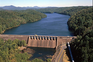
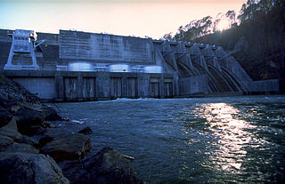
Norris Dam is a hydroelectric and flood control structure located on the Clinch River in Anderson County and Campbell County, Tennessee, United States. The dam was the first major project for the Tennessee Valley Authority, which had been created in 1933 to bring economic development to the region and control the rampant flooding that had long plagued the Tennessee Valley. The dam was named in honor of Nebraska Senator George Norris (1861–1944), a longtime supporter of government-owned utilities in general, and supporter of TVA in particular. The infrastructure project was listed on the National Register of Historic Places in 2016.

Tellico Dam is a dam built by the Tennessee Valley Authority (TVA) in Loudon County, Tennessee on the Little Tennessee River, just above the main stem of the Tennessee River. Completed in 1979, it impounds the Tellico Reservoir.

Watts Bar Dam is a hydroelectric dam on the Tennessee River in Meigs and Rhea counties in Tennessee, United States. The dam is one of nine dams on the main Tennessee River channel operated by the Tennessee Valley Authority, which built the dam in the early 1940s to provide flood control and electricity and to help create a continuous navigable channel along the entire length of the river. The dam is the technical boundary between the 39,090-acre (15,820 ha) Watts Bar Lake— which it impounds— and Chickamauga Lake, which stretches from the dam's tailwaters southward to Chattanooga.

Fort Loudoun Dam is a hydroelectric dam on the Tennessee River in Loudon County, Tennessee, in the southeastern United States. The dam is operated by the Tennessee Valley Authority (TVA), which built the dam in the early 1940s as part of a unified plan to provide electricity and flood control in the Tennessee Valley and create a continuous 652-mile (1,049 km) navigable river channel from Knoxville, Tennessee to Paducah, Kentucky. It is the uppermost of nine TVA dams on the Tennessee River.

Guntersville Dam is a hydroelectric dam on the Tennessee River in Marshall County, in the U.S. state of Alabama. It is one of nine dams on the river owned and operated by the Tennessee Valley Authority, which built the dam in the late 1930s as part of a New Deal era initiative to create a continuous navigation channel on the entire length of the river and bring flood control and economic development to the region. The dam impounds the Guntersville Lake of 67,900 acres (27,500 ha), and its tailwaters feed into Wheeler Lake.

Wheeler Dam is a hydroelectric dam on the Tennessee River between Lauderdale County and Lawrence County in Alabama. It is one of nine dams on the river owned and operated by the Tennessee Valley Authority, which built the dam in the mid-1930s as part of a New Deal-era initiative to improve navigation on the river and bring flood control and economic development to the region. The dam impounds the Wheeler Lake of 67,070 acres (27,140 ha) and its tailwaters feed into Wilson Lake.

The Chickamauga Dam is a hydroelectric dam on the Tennessee River in Chattanooga, Tennessee, United States. The dam is owned and operated by the Tennessee Valley Authority, which built the dam in the late 1930s as part of a New Deal era initiative to improve navigation and bring flood control and economic development to the Tennessee Valley. The dam impounds the 36,240-acre (14,670 ha) Chickamauga Lake and feeds into Nickajack Lake. The dam and associated infrastructure were listed on the National Register of Historic Places in 2017.

Douglas Dam is a hydroelectric dam on the French Broad River in Sevier County, Tennessee, in the southeastern United States. The dam is operated by the Tennessee Valley Authority (TVA), which built the dam in record time in the early 1940s to meet emergency energy demands at the height of World War II. Douglas Dam is a straight reinforced concrete gravity-type dam 1705 feet long and 202 feet high, impounding the 28,420-acre (11,500 ha) Douglas Lake. The dam was named for Douglas Bluff, a cliff overlooking the dam site prior to construction.
Apalachia Dam is a hydroelectric dam on the Hiwassee River in Cherokee County, in the U.S. state of North Carolina. The dam is the lowermost of three dams on the river owned and operated by the Tennessee Valley Authority, which built the dam in the early 1940s to provide emergency power for aluminum production during World War II. While the dam is in North Carolina, an 8.3-mile (13.4 km) underground conduit carries water from the dam's reservoir to the powerhouse located 12 miles (19 km) downstream across the state line in Polk County, Tennessee. The dam and associated infrastructure were listed on the National Register of Historic Places in 2017.
Cherokee Lake, also known as Cherokee Reservoir, is an artificial reservoir in the U.S. state of Tennessee formed by the impoundment of the Holston River behind Cherokee Dam.
Watauga Dam is a hydroelectric and flood control dam on the Watauga River in Carter County, in the U.S. state of Tennessee. It is owned and operated by the Tennessee Valley Authority, which built the dam in the 1940s as part of efforts to control flooding in the Tennessee River watershed. At 318 feet (97 m), Watauga is the second-highest dam in the TVA river and reservoir system, and at the time of its completion was one of the highest earth-and-rock dams in the United States. The dam impounds the TVA Watauga Reservoir of 6,430 acres (2,600 ha), and its tailwaters feed into Wilbur Lake. The Appalachian Trail crosses the top of Watauga Dam.
Blue Ridge Dam is a hydroelectric dam on the Toccoa River in Fannin County, in the U.S. state of Georgia. It is the uppermost of four dams on the Toccoa/Ocoee River owned and operated by the Tennessee Valley Authority. The dam impounds the 3,300-acre (1,300 ha) Blue Ridge Lake on the southwestern fringe of the Blue Ridge Mountains.

Hiwassee Dam is a hydroelectric dam on the Hiwassee River in Cherokee County, in the U.S. state of North Carolina. It is one of three dams on the river owned and operated by the Tennessee Valley Authority, which built the dam in the late 1930s to bring flood control and electricity to the region. The dam impounds the Hiwassee Lake of 6,000 acres (2,400 ha), and its tailwaters are part of Apalachia Lake. At 307 feet (94 m), Hiwassee Dam is the third highest dam in the TVA system, behind only Fontana and Watauga. The dam and associated infrastructure was listed on the National Register of Historic Places in 2017.

Nottely Dam is a hydroelectric and flood storage dam on the Nottely River in Union County, in the U.S. state of Georgia. The dam is owned and operated by the Tennessee Valley Authority, which built the dam in the early 1940s as a flood control structure and to help regulate flow at nearby Hiwassee Dam. The dam impounds the Lake Nottely of 4,180 acres (16.9 km2). While the dam was built primarily for flood storage, a generator was installed at Nottely in the 1950s, giving it a small hydroelectric output.

Chatuge Dam is a flood control and hydroelectric dam on the Hiwassee River in Clay County, in the U.S. state of North Carolina. The dam is the uppermost of three dams on the river owned and operated by the Tennessee Valley Authority, which built the dam in the early 1940s for flood storage and to provide flow regulation at Hiwassee Dam further downstream. The dam impounds the 7,000-acre (2,800 ha) Chatuge Lake, which straddles the North Carolina-Georgia state line. While originally built solely for flood storage, a generator installed at Chatuge in the 1950s gives the dam a small hydroelectric output. The dam and associated infrastructure was listed on the National Register of Historic Places in 2017.

South Holston Dam is a hydroelectric and flood control dam on the South Fork Holston River in Sullivan County, in the U.S. state of Tennessee. It is the uppermost of three dams on the South Fork Holston owned and operated by the Tennessee Valley Authority, which built the dam in the 1940s as part of efforts to control flooding in the Tennessee River watershed. On October 21, 1950 the valve gate closed and water began backing up to create South Holston Reservoir. Work began on the dam in December 1941, but in November 1942, the War Production Board requested that the operation be suspended because of a shortage of critical materials. Work did not resume until July 1, 1947. The dam now impounds the South Holston Lake of 7,550 acres (3,060 ha), which extends northeastward across the Tennessee-Virginia state line.

Wilbur Dam is a hydroelectric dam on the Watauga River in Carter County, in the U.S. state of Tennessee. It is one of two dams on the river owned and operated by the Tennessee Valley Authority. The dam impounds Wilbur Lake, which extends for about 3 miles (4.8 km) up the Watauga to the base of Watauga Dam. Wilbur Dam was completed in 1912 making it the second oldest dam in the TVA system behind Ocoee Dam No. 1. Wilbur Dam was one of the first major hydroelectric projects in Tennessee, and remains one of the oldest dams in the TVA system.
Boone Dam is a hydroelectric and flood control dam on the South Fork Holston River on the border between Sullivan County and Washington County in the U.S. state of Tennessee. It is one of three dams on the South Fork Holston owned and operated by the Tennessee Valley Authority, which built the dam in the early 1950s as part of greater efforts to control flooding in the Tennessee River watershed. The dam impounds the 4,500-acre (1,800 ha) Boone Lake, and its tailwaters are part of Fort Patrick Henry Lake. The dam and associated infrastructure were listed on the National Register of Historic Places in 2017.

Fort Patrick Henry Dam is a hydroelectric dam on the South Fork Holston River within the city of Kingsport, in Sullivan County in the U.S. state of Tennessee. It is the lowermost of three dams on the South Fork Holston owned and operated by the Tennessee Valley Authority, which built the dam in the early 1950s to take advantage of the hydroelectric potential created by the regulation of river flow with the completion of Watauga Dam, South Holston Dam, and Boone Dam further upstream in preceding years. The dam impounds the 872-acre (353 ha) Fort Patrick Henry Lake. While originally built for hydroelectric generation, the dam now plays an important role in the regulation of water flow and water temperature for the John Sevier Fossil Plant and other industrial plants downstream. The dam and associated infrastructure were listed on the National Register of Historic Places in 2017.
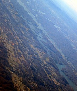
Norris Lake, also known as Norris Reservoir, is a reservoir that is located in Tennessee, United States. The lake was created by the Norris Dam at the Cove Creek Site on the Clinch River in 1936 by the Tennessee Valley Authority (TVA) for flood control, water storage, and hydroelectric power. Norris Dam and its reservoir were the first major project taken on by the TVA. The lake, the dam, and the town of Norris, Tennessee are named for George W. Norris, who was a U.S. Senator from Nebraska and who wrote the legislation that created the TVA.


