Coal mining in the Midlothian area of Chesterfield County began in the 18th century. Around 1701, French Huguenot settlers to the area discovered the existence of the coalfield. The coalfield was part of the Richmond Basin which is one of the Eastern North America Rift Basins which contains some sedimentary rock and bituminous coal. In a 1709 diary entry William Byrd II, who is credited as the founder of Richmond, and had purchased 344 acres (139ha) of land in the area where coal was found, noted that "the coaler found the coal mine very good and sufficient to furnish several generations." It was first commercially mined in the 1730s, and was used to make cannon at Westham (near the present Huguenot Memorial Bridge) during the American Revolutionary War.[2]
In 1804, the Manchester and Falling Creek Turnpike was built to ease traffic on what is now Old Buckingham Road. In 1807, became the first graveled roadway of any length in Virginia.[2] However, by 1824, Midlothian area coal mine owners were frustrated by the difficulty of transporting on the toll road, now known as Midlothian Turnpike, more than 1,000,000 bushels of coal by wagons and horse teams to waiting ships below the falls at Manchester on the banks of the James River.
Seeking a better method of transportation so that their markets could be expanded, in 1825, a group of mine owners, including Nicholas Mills, Beverly Randolph and Abraham S. Wooldridge, resolved to build a tramway. The Wooldridge family hailed from East Lothian and West Lothian in Scotland, and named their mining company Mid-Lothian, the source of the modern name.
Planning and construction 1827-1831
In the winter of 1827, Claudius Crozet, Virginia's State Engineer, surveyed the proposed route and deemed it feasible for construction. This feasibility study was necessary to obtain funding assistance from the Virginia Board of Public Works, a state agency which, beginning in 1816, invested in a portion of the stock of privately managed companies building canals, turnpikes, and, later, railroads.[3][4]
In February 1828, the Chesterfield Railroad Company obtained its charter from the Virginia General Assembly. Within a year, $100,000 stock was subscribed, half purchased by the colliers of Chesterfield County and half by Richmond-area investors. The company hired Moncure Robinson, (1802–1891) a European-trained engineer and U.S. railroad pioneer to supervise construction.
In 1830, capital stock was increased to $150,000 to cover unexpectedly high construction expenses. By June 1831, the construction was completed at $127,000 total cost.
Labeled as the Coal Brook RR on this 1856 map
Most profitable railroad in the world 1831-1850
By September, 1831, the railroad was operational, using horses, mules and gravity as motive power. One hundred and sixty cars were put into operation, and it was an instant financial success.
In 1836, the Chesterfield Railroad Company reported carrying 25,903 cars, 84,976 tons (77,089 tonnes) of coal. It received gross revenues of $83,409. This equaled 19% of stockholders' original investment repaid plus 6% dividend. It was reputed to be the most profitable railroad in the world at the time.
In 1840, one of the mining companies reported that 300,000 bushels of coal were extracted from the 777-foot (237m)-deep Pump Shaft alone, one of the more active mines, using the labor of approximately 150 men and 25 mules.[5] It is believed that most of this coal was shipped out by the Chesterfield Railroad.
By 1844, the Chesterfield Railroad had repaid the stockholders' entire original investment and consequently came under regulation of Virginia Board of Public Works, which adjusted charges to fix a dividend return of 6%. The rate for carrying coal reduced from 6¢ per bushel to 3¢.
Outmoded by steam railroad competition 1850-1851
While the Chesterfield Railroad was founded to move coal to Richmond 13 miles (21 km) to the East, the Richmond and Danville railroad replaced it in the 1850s.
In 1850, the new steam-driven Richmond and Danville Railroad began operation to Coalfield Station (later renamed Midlothian). Although unsuccessful lawsuits followed, the Chesterfield Railroad was quickly supplanted by the competition. It filed its last report with the Virginia Board of Public Works in 1851. With permission from the state legislature, the Chesterfield Railroad was dismantled before the American Civil War.[5]
Design features
Operating its entire lifetime without any locomotives, Chesterfield Railroads moved its railcars loaded with coal mostly by gravity downhill to the docks on the James River at the southern edge of Manchester. In places where the line ran uphill, mules helped the cars climb some slopes. The empty cars were hauled back uphill by the mules to the mine, to be reloaded again. In one area the weight of the loaded cars and their downhill motion pulled the empty cars (connected to the full ones by ropes and drums) back toward the mines.
One of the most remarkable features was a cycloidal inclined plane, a drum and rope device by which loaded coal-carrying cars lowered down the steep western slope of Falling Creek Valley pulled by two empty cars traveling up the slope. On the eastern side, the loaded cars were then raised 80 feet (24m) over a 1,000-foot (300m) distance, with power supplied by animals. After completing that movement, the roadbed was mostly a gradual downhill slope over relatively level terrain towards Manchester.
Revenues
1843: $37,104.43 for 11,496 cars (822,200 bushels)[6]
1847: $37,329.55 for 20,694 cars (1,552,050 bushels)[7]
1849: $39,591.95 for 17,723 cars of coal (1,329,225 bushels)[8]
The Chesterfield Railroad is commemorated by two Virginia Historical Markers and an exhibit in the Chesterfield County Museum, located near the court house. In addition, various portions of the road bed still exist today.
Gallery
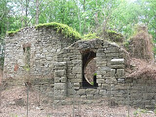
Remnants of the Chesterfield Railroad
The now damaged granite block eastern and western abutments that were part of the Falling Creek Railroad Bridge of the Chesterfield Railroad.
This is the railroad bed, looking West, of the Chesterfield Railroad over Pocoshock Creek in Chesterfield County, Virginia.
First Railroad in Virginia Historical marker & remnant site nearby
Historical marker |VA-S30, is located on U.S. Route 60, at Pocoshock Creek, 3.78 miles (6.08km) west of the Richmond city limits at State Route 150, and 1.5 miles (2.41km) west of the junctions of US Highway 60 and State Route 76.
At this location, a short portion of the former rail bed on a fill is still visible just south of the marker, between a retail center and a condominium complex.
Chesterfield Railroad Virginia Historical marker & remnant site nearby
Historical marker |VA-O64 is located about 2 miles (3.2km) east of the Village of Midlothian in U.S. Route 60.
Just 1 mile (1.6km) west of this marker, the site of the cycloidal inclined plane on the steep western slope of Falling Creek Valley is still recognizable and juxtaposes the remains of the railroad bridge at Falling Creek. The location is about 1-mile (1.6km) east of the Village of Midlothian on U.S. Route 60.
Chesterfield County Museum
An exhibit on local mining history in the Chesterfield Museum includes a length of iron rail from the incline railway, first in Virginia.
Extant Remnants
After its discontinuation in 1851, the Chesterfield Railroad roadbed was used as a trail or road for various sections and as a property boundary. In the 20th century, Richmond greatly expanded and much of the old roadbed has been demolished to make way for new developments. Some sections still remain:
The first half mile before terminating in the Stonehenge Village shopping center
A tenth of a mile from Alverser Drive to the Jaguar car dealership
A quarter of a mile centering on Pocoshock Creek
A few long sections around Chippenham Parkway
Furthermore, some sections of the spur lines exist: a twentieth of a mile section of the spur to the Chesterfield Coal and Iron Mining Company (formerly known locally as the "English" company) southeast of the intersection of Walton Park Road and Walton Park Lane and a few sections of the Midlothian company spur, which the Richmond and Danville Railroad used as the southern part of its Midlothian spur.
Chesterfield Railroad route map (in orange), December 2020. Key: 1. Chesterfield Railroad (orange) 2. CRR spur to English company mines (purple-red) 3. CRR spur to Midlothian company mines (green) 4. Midlothian Turnpike/Buckingham Road (brown) 5. River Road (red)
Thomas F. Garner, Jr., editor, Historically Significant Sites on the Mid-Lothian Coal Mining Co. Tract In Chesterfield County, Virginia, a collection of articles and excerpts
Coleman, Elizabeth Dabney (1954) Forerunner of Virginia's First Railway by Virginia Caval-cade Magazine, Volume IV, Number 3, page 7. Virginia State Library: Winter issue, 1954.
Scarburgh, George Parker, (1850), Opinion of Honorable George P. Scarburgh, of Accomac, Virginia, in the cases between the Chesterfield Railroad Company and the Richmond and Danville Railroad Company Richmond, VA: H. K. Ellyson
Gamst, Frederick C. (1990) The Ingenious Railroad on Falling Creek, Virginia's First article in: The Messenger Chesterfield Courthouse, VA (October 1990 issue . No.18, p.1, 4-9)
James, George Watson (1967), Gravity plus mules equal "steam." in: Virginia Record Richmond, VA. (April 1967 issue v.89, no.4, p.8)
Chesterfield County is located just south of Richmond in the Commonwealth of Virginia. The county's borders are primarily defined by the James River to the north and the Appomattox River to the south. Its county seat is Chesterfield Court House.
Manchester is a former independent city in Virginia in the United States. Prior to receiving independent status, it served as the county seat of Chesterfield County, between 1870 and 1876. Today, it is a part of the city of Richmond, Virginia.
The Richmond and Danville Railroad (R&D) Company was a railroad that operated independently from 1847 until 1894, first in the U.S. state of Virginia, and later on 3,300 miles (5,300 km) of track in nine states.
Midlothian is an unincorporated area in Chesterfield County, Virginia, U.S. Settled as a coal town, Midlothian village experienced suburbanization effects and is now part of the western suburbs of Richmond, Virginia south of the James River in the Greater Richmond Region. Because of its unincorporated status, Midlothian has no formal government, and the name is used to represent the original small Village of Midlothian and a vast expanse of Chesterfield County in the northwest portion of Southside Richmond served by the Midlothian post office.
Drewry's Bluff is located in northeastern Chesterfield County, Virginia, in the United States. It was the site of Confederate Fort Darling during the American Civil War. It was named for a local landowner, Confederate Captain Augustus H. Drewry, who owned the property.
The James River and Kanawha Canal was a partially built canal in Virginia intended to facilitate shipments of passengers and freight by water between the western counties of Virginia and the coast. Ultimately its towpath became the roadbed for a rail line following the same course.
Falling Creek is a tributary of the James River located near Richmond, Virginia. Approximately 23 miles (37 km) in length, it varies in width between 10 feet (3.0 m) at its source to several hundred feet in the Falling Creek Reservoir. Falling Creek rises in the Salisbury section of northwestern Chesterfield County, flows through Southside Richmond and empties into the James River roughly one mile south of the Richmond city limits. A dam located in the Meadowbrook section of the county at Hopkins Road forms the Falling Creek Reservoir, formerly used as northern Chesterfield's drinking water supply.
The Southside of Richmond is an area of the Metropolitan Statistical Area surrounding Richmond, Virginia. It generally includes all portions of the City of Richmond that lie south of the James River, and includes all of the former city of Manchester. Depending on context, the term "Southside of Richmond" can include some northern areas of adjacent Chesterfield County, Virginia in the Richmond-Petersburg region. With minor exceptions near Bon Air, VA, the Chippenham Parkway forms the border between Chesterfield County and the City of Richmond portions of Southside, with some news agencies using the term "South Richmond" to refer to the locations in Southside located in the city proper.
Transportation in Richmond, Virginia and its immediate surroundings include land, sea and air modes. This article includes the independent city and portions of the contiguous counties of Henrico and Chesterfield. While almost all of Henrico County would be considered part of the Richmond area, southern and eastern portions of Chesterfield adjoin the three smaller independent cities of Petersburg, Hopewell, and Colonial Heights, collectively commonly called the Tri-Cities area. A largely rural section of southwestern Chesterfield may be considered not a portion of either suburban area.
The Richmond and Petersburg Railroad moved passengers and goods between Richmond and Petersburg from 1838 to 1898. It survived the American Civil War and eventually merged into the Atlantic Coast Line Railroad in 1900.
U.S. Route 60 (US 60) in the Commonwealth of Virginia runs 303 miles (488 km) west to east through the central part of the state, generally close to and paralleling the Interstate 64 corridor, except for the crossing of the Blue Ridge Mountains, and in the South Hampton Roads area.
The Manchester Turnpike was a turnpike in Chesterfield County in the U.S. state of Virginia, and was the first paved or artificial roadway in that state. It stretched from Manchester west to Falling Creek near Midlothian, and is now known as Midlothian Turnpike, mostly forming part of U.S. Route 60 (US 60).
Black Heath was a house and coal mine located along the Old Buckingham Road in the present Midlothian area of Chesterfield County, Virginia. The Black Heath coal mining enterprises were operated by the Heth family between 1785 and 1844, when the mine closed following a fatal explosion.
In 1886, Randolph Harrison, of the Virginia department of Agriculture, cited Cumberland Mining Company, stating that the United States had purchased stock in the Brighthope Railway. He continued by citing their assertion that extending the railway into Cumberland would increase the value of farms there because they could sell consumer agricultural products such as fruit, dairy and vegetables to all markets of Virginia. The Brighthope Railway was founded in 1877 by the creditors of the Clover Hill Railroad who bought that railroad when the Clover Hill Railroad went bankrupt. The Brighthope Railway continued in the role of the Clover Hill Railroad, hauling coal from the Clover Hill Pits at Winterpock, Virginia. In addition to coal, the Bright Hope Railway transported timber and agricultural products and had passenger service. The Bright Hope Railway was narrowed from standard gauge to narrow gauge and rerouted in 1881. In 1886, much of the southern rails were changed to standard gauge. The Brighthope Railway was not changed back.
The Clover Hill Railroad was a railroad company that operated for 36 years in central Virginia near Richmond. The railroad was created to carry coal most efficiently from the Clover Hill Pits in Winterpock, Virginia, to further transportation points in Chester, Virginia, where it could be sold for a better price than on the Appomattox River in the Piedmont region. This made the railroad important to the Confederacy in the Civil War to ensure a supply of coal for munitions and iron working. The mines were dangerous for the miners, and many accidents occurred. The railroad had to be sold when coal mining declined so that new owners could find other uses for the railroad.
In 1886, Randolph Harrison, of the Virginia department of Agriculture, cited Cumberland Mining Company, stating that businessmen would soon open a hotel at Lithia Springs, Farmville, VA for people seeking the healing waters. The Brighthope railway would be extended to bring them there. But instead, the Farmville and Powhatan Railroad Company built the narrow gauge rails through Cumberland County and the Farmville and Powhatan Railroad Company bought the Brighthope Railway, so the Farmville and Powhatan Railroad made the connection. In 1890, Beach Station was built with a railroad depot, some railroad shanties, a general store and an owner's house, the George Perdue House as a stop on the line.
The Clover Hill Pits are a number of coal shafts and mines that operated in the Southside area of Richmond, Virginia, from 1837 until around 1883.
The Farmville and Powhatan Railroad went bankrupt in 1905 and became the Tidewater and Western Railroad. The line survived until 1917 when it was pulled up and sent to France for the World War I effort. The Tidewater and Western Railroad carried freight and passengers along a route from Farmville, Virginia to Bermuda Hundred. The Tidewater and Western Railroad continued to have Western Union Telegraphs run along the rails. These connected to telegraphs on the Atlantic Coast Line along the East Coast of the US and to Europe.
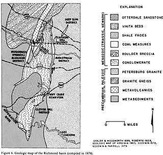
The Richmond Basin was one of the Eastern North America Rift Basins. It lies over Swift Creek Reservoir from Interstate 64 to the Appomattox River.
The Richmond Coalfield was the first coalfield to be mined commercially in the United States of America. The coalfield is located several miles west of the city of Richmond, Virginia. Its bituminous coal seams are a part of the Richmond Basin, dating to the Late Triassic.
This page is based on this Wikipedia article Text is available under the CC BY-SA 4.0 license; additional terms may apply. Images, videos and audio are available under their respective licenses.