Interstate 94 (I-94) is an east–west Interstate Highway connecting the Great Lakes and northern Great Plains regions of the United States. Its western terminus is in Billings, Montana, at a junction with I-90; its eastern terminus is in Port Huron, Michigan, where it meets with I-69 and crosses the Blue Water Bridge into Sarnia, Ontario, Canada, where the route becomes Ontario Highway 402. It thus lies along the primary overland route from Seattle to Toronto, and is the only east–west Interstate highway to have a direct connection to Canada.

The Chicago, Milwaukee, St. Paul and Pacific Railroad (CMStP&P), often referred to as the "Milwaukee Road", was a Class I railroad that operated in the Midwest and Northwest of the United States from 1847 until 1986.

The Empire Builder is an Amtrak long-distance passenger train that operates daily between Chicago and either Seattle or Portland via two sections west of Spokane. Introduced in 1929, it was the flagship passenger train of the Great Northern Railway and its successor, the Burlington Northern Railroad, and was retained by Amtrak when it took over intercity rail service in 1971.

The Bitterroot Range is a mountain range and a subrange of the Rocky Mountains that runs along the border of Montana and Idaho in the northwestern United States. The range spans an area of 24,223 square miles (62,740 km2) and is named after the bitterroot, a small pink flower that is the state flower of Montana.
Taft is a ghost town in the western United States in Mineral County, Montana. Located in the Bitterroot Range near the Idaho border along the route of the Mullan Road, it was a thriving railroad town c. 1908, named after William H. Taft.

The Idaho Panhandle National Forests are a jointly administered set of three national forests located mostly in the U.S. state of Idaho. In 1973, major portions of the Kaniksu, Coeur d'Alene, and St. Joe National Forests were combined to be administratively managed as the Idaho Panhandle National Forests (IPNF). The IPNF consists of more than 2.5 million acres (10,000 km2) of public lands in the panhandle of north Idaho, with small areas extending into eastern Washington (4.7%) and western Montana (1.2%). The northernmost portion of the IPNF share a boundary with Canada. The Forest Supervisor's office is located in Coeur d'Alene, Idaho with district office's in Bonners Ferry, Sandpoint, Priest River, Fernan and Smelterville, and St. Maries and Avery.

The Olympian and its successor the Olympian Hiawatha were passenger trains operated by the Chicago, Milwaukee, St. Paul and Pacific Railroad between Chicago and the Pacific Northwest. The Olympian operated from 1911 to 1947 and was, along with its running mate the Columbian, the first all-steel train to operate in the Pacific Northwest. The streamlined Olympian Hiawatha operated from 1947 to 1961 and was one of several Milwaukee Road trains to carry the name "Hiawatha." The Olympian Hiawatha was designed by industrial designer Brooks Stevens and included the distinctive glassed-in "Skytop" observation-sleeping cars. It later featured full-length "Super Dome" cars.

Avery is a small unincorporated community in the northwest United States, located in the St. Joe River Valley in Shoshone County, Idaho. Avery is located in the middle of the St. Joe District of the Idaho Panhandle National Forest, and is a tourist attraction in the Idaho Panhandle known for its wilderness and outdoor recreation. It is upstream and east of St. Maries, the county seat of Benewah County.

Iron Horse State Park, part of the Washington State Park System, is a 1,612-acre (7 km2) state park located in the Cascade Mountains and Yakima River Valley, between Cedar Falls on the west and the Columbia River on the east.
The Snoqualmie Tunnel is a former railroad tunnel near Snoqualmie Pass in the U.S. state of Washington, located east of Seattle. The tunnel crosses the Cascade Range about three miles (5 km) south of the pass, which is used by Interstate 90, on the border between King County and Kittitas County. It is 11,894 feet long and is at an approximate elevation of 2,600 feet (790 m) above sea level, just north of Keechelus Lake. Its east portal is at Hyak.

The Silver Valley is a region in the northwest United States, in the Coeur d'Alene Mountains in northern Idaho. It is noted for its mining heritage, dating back to the 1880s.

Lookout Pass is a mountain pass in the Rocky Mountains of the northwestern United States. In the Coeur d'Alene Mountains of the Bitterroot Range, the pass is on the border between Idaho and Montana, traversed by Interstate 90 at an elevation of 4,710 feet (1,436 m) above sea level.

Lookout Pass Ski and Recreation Area is a ski area in the western United States. It is at Lookout Pass on Interstate 90, on the border of Idaho and Montana, five miles (8 km) east of Mullan, Idaho. It has a summit elevation of 5,650 ft (1,720 m) on Runt Mountain with a vertical drop of 1,150 ft (350 m) on the northeast-facing slopes. Lookout Pass operates seven days per week from the beginning of the ski season until late March then six days a week until closing, which is usually mid-April.
The Northern Transcon, a route operated by the BNSF Railway, traverses the most northerly route of any railroad in the western United States. This route was originally part of the Chicago, Burlington and Quincy Railroad, Northern Pacific Railway, Great Northern Railway and Spokane, Portland and Seattle Railway systems, merged into the Burlington Northern Railroad system in 1970.

Keechelus Lake is a lake and reservoir in the northwest United States, near Hyak in Kittitas County, Washington. Approximately fifty miles (80 km) southeast of Seattle and a few miles southeast of Snoqualmie Pass, it is the source of the Yakima River.
The Montana Railroad was an American railroad built and operated between the towns of Lombard and Lewistown, Montana, a distance of approximately 157 miles. The railroad connected with the national railway network via a connection with the Northern Pacific Railway at Lombard. The Montana Railroad line was constructed between 1895 and 1903, and operated independently until 1908, when it was acquired by the Chicago, Milwaukee, St. Paul and Pacific Railroad. The railroad was colloquially known as "the Jawbone", because of the contrast between the promising statements of the line's promoters and the company's perennially-weak financial position.

Pipestone Pass is a mountain pass in the Rocky Mountains of Montana in the United States. It sits on the Continental Divide in Silver Bow County, Montana, 10 miles south of Butte, Montana in Beaverhead-Deerlodge National Forest at an elevation of 6,453 ft (1,967 m).
Haugan is an unincorporated community in Mineral County, Montana, United States. Haugan is situated 16 miles (26 km) east of the Idaho border and 90 miles (140 km) west of Missoula on Interstate 90 at the Haugan Exit #16. The St. Regis River flows through the community.
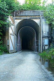
The St. Paul Pass Tunnel was a railway tunnel in the northwest United States at St. Paul Pass, on the Montana-Idaho border. The tunnel was on the main line of the Chicago, Milwaukee, St. Paul & Pacific Railroad, commonly known as "The Milwaukee Road."


