
Lake Mweru is a freshwater lake on the longest arm of Africa's second-longest river, the Congo. Located on the border between Zambia and Democratic Republic of the Congo, it makes up 110 kilometres (68 mi) of the total length of the Congo, lying between its Luapula River (upstream) and Luvua River (downstream) segments.
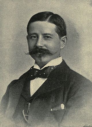
Sir Henry Hamilton Johnston was a British explorer, botanist, artist, colonial administrator, and linguist who travelled widely across Africa to speak some of the languages spoken by people on that continent. He published 40 books on subjects related to the continent of Africa and was one of the key players in the Scramble for Africa that occurred at the end of the 19th century.
This article deals with the disputed area on the borders of the Democratic Republic of the Congo and Zambia, in Luapula Province.

The Luapula River is a north-flowing river of central Africa, within the Congo River watershed. It rises in the wetlands of Lake Bangweulu (Zambia), which are fed by the Chambeshi River. The Luapula flows west then north, marking the border between Zambia and the Democratic Republic of the Congo before emptying into Lake Mweru. The river gives its name to Zambia's Luapula Province.
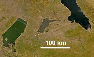
Lake Mweru Wantipa or Mweru-wa-Ntipa meaning "muddy lake" is a lake and swamp system in the Northern Province of Zambia. It has been regarded in the past as something of mystery, displaying fluctuations in water level and salinity which were not entirely explained by variation in rainfall levels; it has been known to dry out almost completely. This is compounded by its remoteness and it not receiving the same attention from geographers and geologists as its larger and more accessible neighbours, Lake Tanganyika, 25 km east, and Lake Mweru, 40 km west, with which its name is sometimes confused.
Nchelenge is a town in the Luapula Province of northern Zambia, lying on the south eastern shore of Lake Mweru. It is contiguous with Kashikishi, and they are sometimes referred to as Nchelenge-Kashikishi. Nchelenge is the administrative centre for the Zambian part of Lake Mweru, being the seat of the district government and branches of national agencies, while Kashikishi is the market and fisheries centre.
Kawambwa is a town in the Zambian province of Luapula located on the edge of the northern Zambian plateau above the Luapula valley at an altitude of 1300 m. It was chosen as an administrative district of the same name by the British colonial authorities who preferred the climate of the plateau rather than the hotter valley where most of the district's population live, and it continues as an administrative district today.

Luapula Province is one of Zambia's ten provinces located in the northern part of the country. Luapula Province is named after the Luapula River and its capital is Mansa. As per the 2022 Zambian census, the Province had a population of 1,519,478, which accounted for 7.72 per cent of the total Zambian population.

Kazembe is a traditional kingdom in modern-day Zambia, and southeastern Congo. For more than 250 years, Kazembe has been an influential kingdom of the Kiluba-Chibemba, speaking the language of the Eastern Luba-Lunda people of south-central Africa. Its position on trade routes in a well-watered, relatively fertile and well-populated area of forestry, fishery and agricultural resources drew expeditions by traders and explorers who called it variously Kasembe, Cazembe and Casembe.

Msiri founded and ruled the Yeke Kingdom in south-east Katanga from about 1856 to 1891. His name is sometimes spelled 'M'Siri' in articles in French. Other variants are "Mziri", "Msidi", and "Mushidi"; and his full name was Mwenda Msiri Ngelengwa Shitambi.
Kashikishi is a town on the south-eastern shore of Lake Mweru in the Luapula Province of Zambia. It lies just north of the district headquarters Nchelenge, and close enough for them to be considered twin towns; they are sometimes referred to as Nchelenge–Kashikishi.
The Congo Pedicle is the southeast salient of the Haut-Katanga Province of the Democratic Republic of the Congo, which divides neighbouring Zambia into two lobes. In area, the pedicle is similar in size to Wales or New Jersey. 'Pedicle' is used in the sense of 'a little foot'. 'Congo Pedicle' or 'the Pedicle' is also used to refer to the Congo Pedicle road, which crosses it.

The Congo Pedicle road crosses the Congolese territory of the Congo Pedicle and was constructed by and is maintained by Zambia to connect its Copperbelt and Luapula Provinces. Both the road and the territory may be referred to as ‘the Pedicle’. It is designated as the N36 Route on the Congolese Road Network.

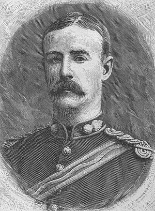
Sir Alfred Sharpe was Commissioner and Consul-General for the British Central Africa Protectorate and first Governor of Nyasaland.
Water transport and the many navigable inland waterways in Zambia have a long tradition of practical use except in parts of the south. Since draught animals such as oxen were not heavily used, water transport was usually the only alternative to going on foot until the 19th century. The history and current importance of Zambian waterways, as well as the types of indigenous boats used, provide information on this important aspect of Zambian economy.
The Stairs Expedition to Katanga (1891−92), led by Captain William Stairs, was the winner in a race between two imperial powers, the British South Africa Company BSAC and the Congo Free State, to claim Katanga, a vast mineral-rich territory in Central Africa for colonization. The mission became notable when a local chief,, was killed, and also for the fact that Stairs, the leader of one side, actually held a commission in the army of the other.
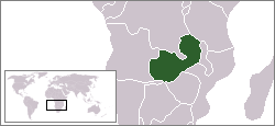
Zambia, officially known as the Republic of Zambia, is a landlocked country in Southern Africa. The neighbouring countries are the Democratic Republic of the Congo to the north, Tanzania to the north-east, Malawi to the east, Mozambique, Zimbabwe, Botswana, and Namibia to the south, and Angola to the west. The capital city is Lusaka, located in the southeast of the country. The population is concentrated mainly around the capital and the Copperbelt to the northwest.

Chiengi District with headquarters at Chiengi is the smallest and most northerly district in the Luapula Province of Zambia and was carved out of Nchelenge District after Zambia's independence. As of the 2010 Zambian Census, the district had a population of 109,147 people. Most of its population live in fishing villages along the 70 km (approx.) of the north-east shore of Lake Mweru which lies within the district. The largest settlement is Puta, 5 km south of Chiengi town, named after Chief Puta. The district is bounded by the DR Congo border in the north, Kaputa District in the east and the Kalungwishi River in the south.

Nchelenge District is a district of Zambia, located in the Luapula Province. The capital lies at Nchelenge. As of the 2000 Zambian Census, the district had a population of 111,119 people.

The Bwile people are an ethnic group that live in the Democratic Republic of the Congo (DRC) and Zambia around the northern part of Lake Mweru.

