
Fremont is a city in Alameda County, California, United States. Located in the East Bay region of the Bay Area, Fremont has a population of 230,504 as of 2020, making it the fourth most populous city in the Bay Area, behind San Jose, San Francisco, and Oakland. It is the closest East Bay city to the high-tech Silicon Valley network of businesses, and has a strong tech industry presence.
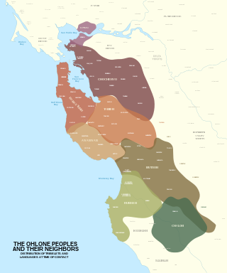
The Ohlone, formerly known as Costanoans, are a Native American people of the Northern California coast. When Spanish explorers and missionaries arrived in the late 18th century, the Ohlone inhabited the area along the coast from San Francisco Bay through Monterey Bay to the lower Salinas Valley. At that time they spoke a variety of related languages. The Ohlone languages make up a sub-family of the Utian language family. Older proposals place Utian within the Penutian language phylum, while newer proposals group it as Yok-Utian.

Union Square is a historic intersection and surrounding neighborhood in Manhattan, New York City, United States, located where Broadway and the former Bowery Road – now Fourth Avenue – came together in the early 19th century. Its name denotes that "here was the union of the two principal thoroughfares of the island". The current Union Square Park is bounded by 14th Street on the south, 17th Street on the north, and Union Square West and Union Square East to the west and east respectively. 17th Street links together Broadway and Park Avenue South on the north end of the park, while Union Square East connects Park Avenue South to Fourth Avenue and the continuation of Broadway on the park's south side. The park is maintained by the New York City Department of Parks and Recreation.
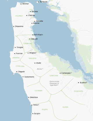
The Ramaytush or Rammay-tuš people are a linguistic subdivision of the Ohlone people of Northern California. The term Ramaytush was first applied to them in the 1970s, but the modern Ohlone people of the peninsula have claimed it as their ethnonym. The ancestors of the Ramaytush Ohlone people have lived on the peninsula—specifically in the area known as San Francisco and San Mateo county—for thousands of years. Prior to the California Genocide, the Ohlone people were not consciously united as a singular socio-political entity. In the early twentieth century anthropologists and linguists began to refer to the Ramaytush Ohlone as San FranciscoCostanoans—the people who spoke a common dialect or language within the Costanoan branch of the Utian family. Anthropologists and linguists similarly called the Tamyen people Santa Clara Costanoans, and the Awaswas people Santa Cruz Costanoans.

The Ohlone Greenway is a 4.5-mile (7.2 km) pedestrian and bicycle path in the East Bay region of the San Francisco Bay Area. The path is named for the Native American Ohlone, who live in the area.
The Lorin District is a neighborhood located in the southern part of Berkeley, California, bounded by Ashby Avenue to the north, Adeline Street and Martin Luther King Jr. Way to the east, Sacramento Street to the west, and 62nd Street to the south. Today, the area is today mostly referred to as "South Berkeley".

The Tamien people are one of eight linguistic divisions of the Ohlone (Costanoan) people groups of Native Americans who live in Northern California. The Tamien traditionally lived throughout the Santa Clara Valley. The use of the name Tamien is on record as early as 1777, it comes from the Ohlone name for the location of the first Mission Santa Clara on the Guadalupe River. Father Pena mentioned in a letter to Junipero Serra that the area around the mission was called Thamien by the native people. The missionary fathers erected the mission on January 17, 1777, at the native village of So-co-is-u-ka.
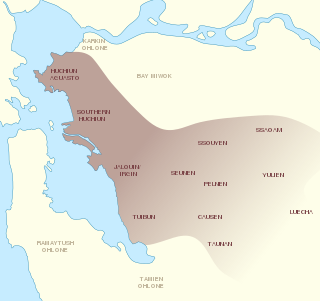
The Chochenyo are one of the divisions of the Indigenous Ohlone (Costanoan) people of Northern California. The Chochenyo reside on the east side of the San Francisco Bay, primarily in what is now Alameda County, and also Contra Costa County, from the Berkeley Hills inland to the western Diablo Range.

North Oakland is an area in Oakland, California, United States, bordered by Downtown Oakland, Oakland Hills, and the adjacent cities of Berkeley, Emeryville and Piedmont. Annexed to Oakland in 1897. It is known as the birthplace of the Black Panther Party and is the childhood home of both its co-founders, Dr. Huey P. Newton and Bobby Seale.
Rancho de las Pulgas was a 35,240-acre (142.6 km2) 1795 Spanish land grant in present-day San Mateo County, California, to José Darío Argüello. The literal translation is "Ranch of the Fleas", probably named after a village of the local Lamchin people. The grant was bounded by San Mateo Creek on the north and San Francisquito Creek on the south, and extended about one league from San Francisco Bay to the hills. The grant encompassed present-day San Mateo, Belmont, San Carlos, Redwood City, Atherton and Menlo Park.
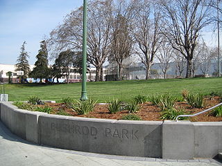
The Bushrod neighborhood in North Oakland, Oakland, California is an area surrounding its namesake park, and bounded by Martin Luther King, Jr. Way to the west, Claremont Avenue to the east, Highway 24 to the south, and the Berkeley border to the north. It borders the neighborhoods of Santa Fe to the west, Fairview Park to the east, and Temescal and Shafter to the south and southeast, respectively. Notable landmarks include the Bushrod Park ballfields and the former Bushrod Washington Elementary School, which share adjoining land on a large greenbelt and open space in the heart of the neighborhood.
Fleming Point is a rocky promontory in the U.S. state of California. The rocky promontory is part of a band of rock, that geologists call the Novato Terrane. Which has been formed through titanic clashes of plates that have pulled the rock upwards. This area is the only original existing shoreline in the East Bay Region today. It is situated in Albany, on the eastern shore of San Francisco Bay. Albany Bulb is an extension of the point, having been formed in the 1960s from construction debris.

Andrew Jackson is a bronze equestrian statue by Clark Mills mounted on a white marble base in the center of Lafayette Square within President's Park in Washington, D.C., just to the north of the White House. Jackson is depicted dressed in military uniform, raising his hat with his right hand, while controlling the reins with his left hand as his horse rises on its rear legs.

Memorial Park, in Hayward, California, is a public park managed by the Hayward Area Recreation and Park District. The park contains an indoor swim center, the Hayward Plunge, which opened in 1936. The park is the access point to the Greenbelt Trails, which follow Ward Creek Canyon adjacent to California State University, East Bay. The park has a small bandstand with musical events offered on major holidays. It borders on Mount Saint Joseph Cemetery which was first established in 1875. It is operated by the All Saints Catholic Church in Hayward. Many of the historic gravestone inscriptions are in Portuguese.
The Karkin people are one of eight Ohlone peoples, indigenous peoples of California.
Chochenyo is the spoken language of the Chochenyo people. Chochenyo is one of the Ohlone languages in the Utian family.

Vincent Medina is an Indigenous rights, Indigenous language, and food activist from California. He co-founded Cafe Ohlone, an Ohlone restaurant in Berkeley, California which serves Indigenous cuisine made with Native ingredients sourced from the San Francisco and Monterey Bay Areas. As of 2019 he was serving on the Muwekma council, and he is Capitán, or cultural leader, of the ‘Itmay Cultural Association.

Corrina Gould, spokeswoman and Tribal Chair of the Confederated Villages of Lisjan/Ohlone, a non-profit organization. She identifies as a Chochenyo and a Karkin Ohlone woman and is a long-time activist who works to protect, preserve, and reclaim ancestral lands of the Ohlone peoples. The Ohlone people live in the greater San Francisco Bay Area, and Gould's organization, specifically, is located in the East Bay, in regions now occupied by Oakland, Berkeley, and beyond.