City Hill, Canberra

Last updated

Aerial view of City Hill and the Vernon Circle. Aerial view of Northbourne Avenue looking north from Civic.jpg
Aerial view of City Hill and the Vernon Circle.

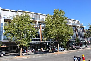
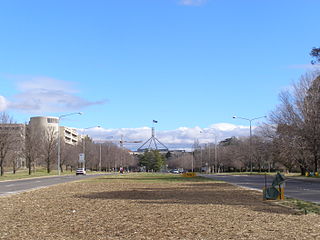
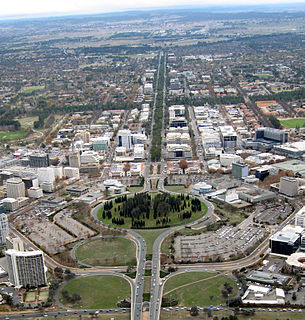
City Hill is a park located in Canberra, Australia on one of the points of the Parliamentary Triangle, a feature of Walter Burley Griffin's plan for the city. The park is surrounded by Vernon Circle, at the south end of Northbourne Avenue but the precinct extends to London Circuit and is an integral part of the city centre design. To the south of the hill Northbourne Avenue becomes Commonwealth Avenue, and further along is Commonwealth Avenue bridge.

Canberra capital city of Australia

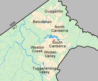
Canberra is the capital city of Australia. Founded following the federation of the colonies of Australia as the seat of government for the new nation, it is Australia's largest inland city and the eighth-largest city overall. The city is located at the northern end of the Australian Capital Territory; 280 km (170 mi) south-west of Sydney and 660 km (410 mi) north-east of Melbourne.

Australia Country in Oceania

Australia, officially the Commonwealth of Australia, is a sovereign country comprising the mainland of the Australian continent, the island of Tasmania, and numerous smaller islands. It is the largest country in Oceania and the world's sixth-largest country by total area. The neighbouring countries are Papua New Guinea, Indonesia, and East Timor to the north; the Solomon Islands and Vanuatu to the north-east; and New Zealand to the south-east. The population of 26 million is highly urbanised and heavily concentrated on the eastern seaboard. Australia's capital is Canberra, and its largest city is Sydney. The country's other major metropolitan areas are Melbourne, Brisbane, Perth, and Adelaide.

Parliamentary Triangle, Canberra ceremonial precinct of Canberra, Australia

The National Triangle, which is referred to as the Parliamentary Triangle, is the ceremonial precinct of Canberra, containing some of Australia's most significant buildings. The National Triangle is formed by Commonwealth, Kings and Constitution Avenues. Buildings within the National Triangle have been located and designed intentionally for visual effect, and those of national significance are popular tourist attractions.

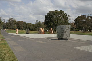
The hill was planted in 1921. The design, supervised by Charles Weston, Canberra's first Superintendent of Parks and Gardens, was to emphasise the vistas along the six avenues radiating from the hill and reinforce the focus that Griffin placed on the hill as forming part of the Parliamentary triangle. At the centre of the hill is a flagpole flying the ACT flag since 1989 when the territory became self-governing. Immediately surrounding the flagpole are double staggered rows of closely spaced Roman cypresses (Cupressus sempervirens Stricta). Radiating outwards are twelve oval shaped groups of Roman cypresses and six groups of Monterey pines (Pinus radiata) reinforcing the symmetrical nature of the design. In 2014 the Canberra Centenary Column was added to the park, to commemorate Canberra's centenary.

Australian Capital Territory Federal territory of Australia, containing the capital city, Canberra

The Australian Capital Territory, formerly known as the Federal Capital Territory until 1938 and commonly referred to as the ACT, is a federal territory of Australia containing the Australian capital city of Canberra and some surrounding townships. It is located in the south-east of the country and is an enclave within the state of New South Wales. Founded after federation as the seat of government for the new nation, all important institutions of the Australian federal government are centred in the Territory.

<i>Cupressus sempervirens</i> species of plant

Cupressus sempervirens, the Mediterranean cypress, is a species of cypress native to the eastern Mediterranean region, in northeast Libya, southern Albania, coastal Bulgaria, southern coastal Croatia, southern Montenegro, southern Bosnia and Herzegovina, southern Greece, southern Turkey, Cyprus, northern Egypt, western Syria, Lebanon, Malta, Italy, Israel, western Jordan, and also a disjunct population in Iran.

Canberra Centenary Column

The Canberra Centenary Column is a sculpture in City Hill, Canberra, Australia. It was built to commemorate the city's centenary, and unveiled on 11 March 2014.

The park is centrally located and well-known, but it is rarely visited as it is away from shops and public areas and is difficult to access because it is surrounded by a major road. The prominent flagpole at the centre of Vernon Circle is not actually at the highest point of City Hill. The highest point of City Hill is to the south east, overlooking Lake Burley Griffin. Unusually for the centre of a large city and as a result of the relative isolation of City Hill, a small variety of mushrooms can be found growing under the pine trees.

Lake Burley Griffin man-made lake in Canberra, Australia

Lake Burley Griffin is an artificial lake in the centre of Canberra, the capital of Australia. It was completed in 1963 after the Molonglo River—which ran between the city centre and Parliamentary Triangle—was dammed. It is named after Walter Burley Griffin, the American architect who won the competition to design the city of Canberra.

Related Research Articles

Walter Burley Griffin American architect and landscape architect

Walter Burley Griffin was an American architect and landscape architect. He is known for designing Canberra, Australia's capital city. He has been credited with the development of the L-shaped floor plan, the carport and an innovative use of reinforced concrete.

Civic, Australian Capital Territory Suburb of Canberra, Australian Capital Territory

Civic is the city centre or central business district of Canberra. "Civic" is a common name for the district, but it is also called Civic Centre, City Centre, Canberra City and Canberra, and its official division name is City.

Braddon, Australian Capital Territory Suburb of Canberra, Australian Capital Territory

Braddon is an inner north suburb of Canberra, Australian Capital Territory, Australia located adjacent to the Canberra CBD.

Capital Hill, Australian Capital Territory Suburb of Canberra, Australian Capital Territory

Capital Hill, is the location of Parliament House, Canberra, at the south apex of the land axis of the Parliamentary Triangle.

Australian Merchant Navy Memorial memorial in Canberra, Australia

The Australian Merchant Navy Memorial is a memorial honouring the Australian Merchant Navy's involvement in World War I and World War II. It is located in Kings Park, on the northern shore of Lake Burley Griffin in Canberra, the national capital city of Australia. Its location at the shore of the lake represent's the Merchant Navy's relationship with water. It was unveiled on 7 October 1990 by Bill Hayden AC, Governor-General of Australia. A memorial service is held on the first Sunday on or after 21 October each year.

Commonwealth Place, Canberra location in Canberra, Australia

Commonwealth Place is located on the southern shore of Lake Burley Griffin, Canberra. It lies along the ‘water axis’ running along the lake from Black Mountain. Commonwealth Place is the location of the Gallery of Australian Design, Reconciliation Place, a restaurant and Speakers Square. Walter Burley Griffin, the architect who designed Canberra, envisaged that the area would be the site of a "water gate" which would have a terrace above it, providing a "forum for the people". Griffin’s vision was for a long time left unrecognised but as of 2005 the area was being developed to reflect the original plan.

Commonwealth Park park in Canberra, Australia

Commonwealth Park is in Canberra, Australia, adjacent to the north side of Lake Burley Griffin. Centrally located in the city, it is an important part of the urban landscape. The park has an area of 34.25 hectares, which includes a variety of natural and constructed spaces.

Telopea Park park in Canberra, Australia

Telopea Park is one of the oldest parks in Canberra, Australia. The name of the park is from Walter Burley Griffin's original plan for Canberra where he planned Telopea Park at the end of Sydney Avenue. The park is named after the floral emblem of New South Wales, also known as the Waratah. Griffin planned that the state capital city avenues were terminated with a park named after the generic botanical name for a native plant from that particular state. The park covers 0.079 km².

Kings Park, Canberra park in Canberra, Australia

Kings Park is a park in Canberra, Australia on the shore of Lake Burley Griffin.

Lennox Gardens urban park in Canberra, Australia

Lennox Gardens, a park in Canberra, Australia, lying on the south side of Lake Burley Griffin, close to Commonwealth Avenue Bridge and Albert Hall in the suburb of Yarralumla. Before the construction of Lake Burley Griffin a road ran through the present garden, this road being one of two main crossing points across the Molonglo River. The name of the road was Lennox Crossing from which the present garden takes its name. The northern segment of the road is still present on Acton peninsula. The garden was officially named in 1963. Lennox Crossing was named after David Lennox, an early bridge builder in NSW and Victoria.

Manuka, Australian Capital Territory neighbourhood of Canberra, Australia

Manuka is an area in the Inner South district of Canberra, Australia covering parts of the suburbs of Griffith and Forrest. Manuka Shops, Manuka Oval, Manuka Swimming Pool, and Manuka Circle take their name from the park in the area.

Kings Avenue, Canberra road in Canberra

Kings Avenue is a road in Canberra which goes between New Parliament House, across Lake Burley Griffin at the Kings Avenue Bridge, to Russell near the Australian-American Monument..

London Circuit road in Canberra

London Circuit is a road in Canberra, Australia, which surrounds City Hill in Civic, the city centre. It has a hexagonal shape, and intersects with several main roads such as Northbourne Avenue, Edinburgh Avenue, Akuna Street, Constitution Avenue and Commonwealth Avenue.

Reconciliation Place sculpture garden

Reconciliation Place is an urban landscape design in the Parliamentary Triangle Canberra, Australia, commenced in 2001 as a monument to reconciliation between Australia’s Indigenous people and settler population.

History of Lake Burley Griffin

The history of Lake Burley Griffin, an artificial body of water in Canberra, the capital of Australia, is a long one. Following its initial design in the 1910s, extensive political disputes occurred until it was finally built in the 1960s.

Constitution Avenue in a street in Canberra, the capital of Australia.

The Immigration Bridge was a proposed footbridge in Canberra, the capital of Australia. It was proposed that it be built between the National Museum of Australia and Lennox Gardens on the south shore of the West Basin of Lake Burley Griffin, in the centre of the city.

Vernon Circle road in Australian Capital Territory, Australia

Vernon Circle is a road in Canberra, Australia that encirles City Hill.

References

Coordinates: 35°16′55″S149°7′43″E / 35.28194°S 149.12861°E / -35.28194; 149.12861

Geographic coordinate system Coordinate system

A geographic coordinate system is a coordinate system that enables every location on Earth to be specified by a set of numbers, letters or symbols. The coordinates are often chosen such that one of the numbers represents a vertical position and two or three of the numbers represent a horizontal position; alternatively, a geographic position may be expressed in a combined three-dimensional Cartesian vector. A common choice of coordinates is latitude, longitude and elevation. To specify a location on a plane requires a map projection.