Corroboree Park

Last updated

Corroboree Park Corroboree Park, Ainslie, Australian Capital Territory.JPG
Corroboree Park

Corroboree Park is in Ainslie, ACT, Canberra, Australia. It is shaped like a semicircle, and is associated with the Aboriginal use of the area prior to European settlement in Canberra. The park was created around 1925 around the 'Corroboree Tree' located in the park. It is in a heritage registered area, and is also a registered heritage park. [1]

Ainslie, Australian Capital Territory Suburb of Canberra, Australian Capital Territory

Ainslie is a leafy suburb of Canberra, Australia in the North Canberra district.

Canberra capital city of Australia

Canberra is the capital city of Australia. Founded following the federation of the colonies of Australia as the seat of government for the new nation, it is Australia's largest inland city and the eighth-largest city overall. The city is located at the northern end of the Australian Capital Territory; 280 km (170 mi) south-west of Sydney and 660 km (410 mi) north-east of Melbourne.

Australia Country in Oceania

Australia, officially the Commonwealth of Australia, is a sovereign country comprising the mainland of the Australian continent, the island of Tasmania, and numerous smaller islands. It is the largest country in Oceania and the world's sixth-largest country by total area. The neighbouring countries are Papua New Guinea, Indonesia, and East Timor to the north; the Solomon Islands and Vanuatu to the north-east; and New Zealand to the south-east. The population of 26 million is highly urbanised and heavily concentrated on the eastern seaboard. Australia's capital is Canberra, and its largest city is Sydney. The country's other major metropolitan areas are Melbourne, Brisbane, Perth, and Adelaide.

Contents

Park facilities

Ainslie Community Hall, which is located in Corroboree Park, is socially significant as one of the early meeting places in Canberra. The wooden hall was erected in 1927 and the adjoining 1920s school building was relocated to its current location from Russell. [2] A fire-damaged part of the hall in 2000 and the school hall has had many internal upgrades including a commercial kitchen. The hall is often used for social gatherings, meetings and classes such as martial arts, yoga and dance.

The three courts for the Ainslie Tennis Club (established in 1927) were built using voluntary labour. The tennis club planted many of the trees in the park. [1]

The Ainslie Tennis Club was one of the first tennis clubs established in Canberra. At 3pm on Saturday 21 April 1928 the club’s Patron, Colonel Goodwin, officially opened the club and served the first ball. Initial work was done using picks, shovels, horse and dray. The original clubhouse was built in 1930 on the south side of the courts. The current clubhouse was opened in 1955. The club and facilities are located in Corroboree Park.

One asphalt-surfaced basketball court is located in the park, as are a small cricket pitch, and a children's playground.

The Corroboree Community Hall is managed by Northside Community Service on behalf of the ACT Government. The ACT Government has more information on the park on its website. [2] [ dead link ]

Around the park

Ainslie Football Club Australian rules football club

Ainslie Football Club is a semi-professional Australian rules football club based in Canberra, in the Australian Capital Territory.

Related Research Articles

Hunters Hill, New South Wales Suburb of Sydney, New South Wales, Australia

Hunters Hill is a suburb on the Lower North Shore and Northern Suburbs of Sydney, in the state of New South Wales, Australia. Hunters Hill is located 9 kilometres (5.6 mi) north-west of the Sydney central business district and is the administrative centre for the local government area of the Municipality of Hunter's Hill.

Reid, Australian Capital Territory Suburb of Canberra, Australian Capital Territory

Reid is a suburb of Canberra, Australian Capital Territory, Australia. With a population of 1,636 at the 2016 census, located directly next to Civic, Reid is one of the oldest suburbs in Canberra.

Braddon, Australian Capital Territory Suburb of Canberra, Australian Capital Territory

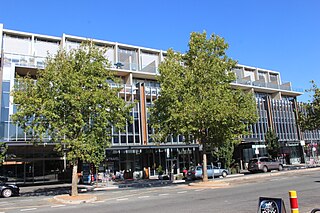
Braddon is an inner north suburb of Canberra, Australian Capital Territory, Australia located adjacent to the Canberra CBD.

Forrest, Australian Capital Territory Suburb of Canberra, Australian Capital Territory

Forrest is an affluent suburb of Canberra, Australian Capital Territory, Australia. Forrest is named after Sir John Forrest, an explorer, legislator, federalist, premier of Western Australia, and one of the fathers of the Australian Constitution. Streets in Forrest are named after explorers and governors. According to the Australian Bureau of Statistics Forrest is the second most Socio-Economic advantaged location in Australia after the neighbouring suburb of Barton.

Barton, Australian Capital Territory Suburb of Canberra, Australian Capital Territory

Barton is a suburb of Canberra, Australian Capital Territory, Australia. At the 2016 census, Barton had a population of 1,439 people.

Griffith, Australian Capital Territory Suburb of Canberra, Australian Capital Territory

Griffith is an early inner-south suburb of Canberra, Australian Capital Territory, Australia.

Kingston, Australian Capital Territory Suburb of Canberra, Australian Capital Territory

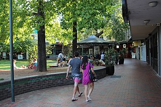
Kingston is the oldest and one of the most densely populated suburbs of Canberra, Australian Capital Territory, Australia. The suburb is named after Charles Cameron Kingston, the former Premier of South Australia and minister in the first Australian Commonwealth Government. It is adjacent to the suburbs of Barton, Fyshwick, Griffith and Manuka. The suburb of Kingston is situated about 4 km from the centre of Canberra.

Albert Hall, Canberra entertainment hall in Canberra, Australia

The Albert Hall is a hall in Canberra, Australia, used for entertainment. It is on Commonwealth Avenue between Commonwealth Bridge and the Hotel Canberra in the suburb of Yarralumla.

Old Parliament House, Canberra former house of the Parliament of Australia

Old Parliament House, known formerly as the Provisional Parliament House, was the seat of the Parliament of Australia from 1927 to 1988. The building began operation on 9 May 1927 after Parliament's relocation from Melbourne to the new capital, Canberra. In 1988, the Commonwealth Parliament transferred to the new Parliament House on Capital Hill. It also serves as a venue for temporary exhibitions, lectures and concerts.

Parliamentary Triangle, Canberra ceremonial precinct of Canberra, Australia

The National Triangle, which is referred to as the Parliamentary Triangle, is the ceremonial precinct of Canberra, containing some of Australia's most significant buildings. The National Triangle is formed by Commonwealth, Kings and Constitution Avenues. Buildings within the National Triangle have been located and designed intentionally for visual effect, and those of national significance are popular tourist attractions.

Glebe Park, Canberra park in Canberra, ACT, Australia

Glebe Park is a public park on the eastern side of Civic, Canberra, Australia. The park is bounded by Coranderrk, Ballumbir, Akuna, and Bunda Streets, and to the south, the National Convention Centre.

Kings Park, Canberra park in Canberra, Australia

Kings Park is a park in Canberra, Australia on the shore of Lake Burley Griffin.

Manuka, Australian Capital Territory neighbourhood of Canberra, Australia

Manuka is an area in the Inner South district of Canberra, Australia covering parts of the suburbs of Griffith and Forrest. Manuka Shops, Manuka Oval, Manuka Swimming Pool, and Manuka Circle take their name from the park in the area.

All Saints Church, Canberra Church in Australian Capital Territory, Australia

The All Saints Church is an Anglican church located in the suburb of Ainslie, Canberra. It is part of the diocese of Canberra and Goulburn in the Anglican Church of Australia.

OConnor, Australian Capital Territory Suburb of Canberra, Australian Capital Territory

O'Connor is a suburb of Canberra, Australia in the North Canberra district. It was named after Richard Edward O'Connor (1851–1912), who was a judge in the High Court and a founder of the Australian constitution. Street names in O'Connor are named after explorers, Australian flora, legislators and pioneers. The suburb name was gazetted on 20 September 1928.

Amaroo, Australian Capital Territory Suburb of Canberra, Australian Capital Territory

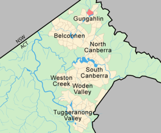
Amaroo is a suburb in the Canberra, Australia district of Gungahlin and was gazetted on 18 October 1991. Amaroo – which means ‘a beautiful place’ in one of the local Aboriginal dialects. Place names in Amaroo such as Shoalhaven Avenue are named after Australian rivers and lakes. Amaroo is adjacent to the suburbs of Ngunnawal, Gungahlin, Moncrieff, Forde, Bonner and Jacka. The suburb is bounded by Mirrabei Drive and Horse Park Drive and Gundaroo Drive. The suburb is located approximately 1 km from the Gungahlin Town Centre and 12 km from the centre of Canberra.

Kingston Powerhouse

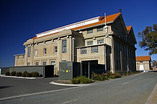
The Kingston Powerhouse is a disused power plant in Canberra, the capital of Australia. It is located in the suburb of Kingston, Australian Capital Territory.

Haig Park park in the suburbs of Braddon and Turner in Canberra, Australia

Haig Park is a park in the suburbs of Braddon and Turner in Canberra, Australia. It lies on either side of Northbourne Avenue.

References

  1. 1 2 3 "20025. Corroboree Park Housing Precinct (Entry to the ACT Heritage Register)" (PDF). ACT Heritage Council. Retrieved 14 March 2014.
  2. 1 2 "Corroboree Park". ACT Territory and Municipal Services. Retrieved 13 March 2014.

Coordinates: 35°16′7″S149°8′30″E / 35.26861°S 149.14167°E / -35.26861; 149.14167

Geographic coordinate system Coordinate system

A geographic coordinate system is a coordinate system that enables every location on Earth to be specified by a set of numbers, letters or symbols. The coordinates are often chosen such that one of the numbers represents a vertical position and two or three of the numbers represent a horizontal position; alternatively, a geographic position may be expressed in a combined three-dimensional Cartesian vector. A common choice of coordinates is latitude, longitude and elevation. To specify a location on a plane requires a map projection.