The London Borough of Islington is a London borough which forms part of Inner London, England. Islington has an estimated population of 215,667. It was formed in 1965, under the London Government Act 1963, by the amalgamation of the metropolitan boroughs of Islington and Finsbury.

Clerkenwell is an area of central London, England.
Finsbury is a district of Central London, forming the southeastern part of the London Borough of Islington. It borders the City of London.

The London Inner Ring Road, or Ring Road as signposted, is a 12-mile (19 km) route with an average diameter of 2.75–5.5 miles (4.43–8.85 km) formed from a number of major roads that encircle Central London. The ring road forms the boundary of the London congestion charge zone, although the ring road itself is not part of the zone.

Pentonville Road is a road in Central London that runs west to east from Kings Cross to City Road at The Angel, Islington. The road is part of the London Inner Ring Road and part of the boundary of the London congestion charge zone.

Old Street is a 1-mile (1.6 km) street in inner north-east Central London, England that runs west to east from Goswell Road in Clerkenwell, in the London Borough of Islington, via St Luke's and Old Street Roundabout, to the crossroads where it meets Shoreditch High Street (south), Kingsland Road (north) and Hackney Road (east) in Shoreditch in the London Borough of Hackney.

Old Street is an interchange station at the junction of Old Street and City Road in Central London for London Underground and National Rail services.

Pentonville is an area in North London, located in the London Borough of Islington. It is located 1.75 miles (2.82 km) north-northeast of Charing Cross on the Inner Ring Road. Pentonville developed in the northwestern edge of the ancient parish of Clerkenwell on the New Road. It is named after Henry Penton, the developer of the area.

Moorfields was an open space, partly in the City of London, lying adjacent to – and outside – its northern wall, near the eponymous Moorgate. It was known for its marshy conditions, the result of the defensive wall acting as a dam, impeding the flow of the River Walbrook and its tributaries.

The Angel, Islington, is a historic landmark and a series of buildings that have stood on the corner of Islington High Street and Pentonville Road in Islington, London, England. The land originally belonged to the Clerkenwell Priory and has had various properties built on it since the 16th century. An inn on the site was called the "Angel Inn" by 1614, and the crossing became generally known as "the Angel". The site was bisected by the New Road, which opened in 1756, and properties on the site have been rebuilt several times up to the 20th century. The corner site gave its name to Angel tube station, opened in 1901, and the surrounding Angel area of London.
The EC postcode area, also known as the London EC postal area, is a group of postcode districts in central London, England. It includes almost all of the City of London and parts of the London boroughs of Islington, Camden, Hackney, Tower Hamlets and Westminster. The area covered is of very high density development. Deliveries for the EC postcode area are made from Mount Pleasant Mail Centre.

Finsbury Pavement is a short length of street in England connecting Moorgate with City Road in the London Borough of Islington. It forms a part of the London Inner Ring Road, and before the introduction of the ring of steel around the City of London it formed a major through-route towards London Bridge and south London.

Essex Road is a main road in Islington, London. It is part of the A104 and connects Islington High Street with Balls Pond Road via Essex Road railway station.

The London Borough of Islington is short of large parks and open spaces, given its status in recent decades as a desirable place of residence. In fact, Islington has the lowest ratio of open space to built-up areas of any London borough. The largest continuous open space in the borough, at 11.75 hectares, is Highbury Fields.

St Luke's is an area in London, England and is located in the London Borough of Islington. It lies just north of the border with the City of London near the Barbican Estate, and the Clerkenwell and Shoreditch areas.

Caledonian Road passes for about a mile and a half north–south through the London Borough of Islington. It connects North London, from Camden Road near its junction with Holloway Road, and central London's Pentonville Road in the south. It is known colloquially as the "Cally" and forms the entirety of the A5203.

Old Street Roundabout is a road junction in Central London, England. Historically a square roundabout, it is now a three-way junction. It is among access points of the Inner Ring Road for the adjoining St Luke's south part of Islington and the City of London beyond, west and south, respectively. It is roughly on the western limit of Hoxton in the London Borough of Hackney which straddles both sides of the Ring Road, a road which after taking up a little of the eastern part of Old Street then veers south-east, taking Great Eastern Street, at Apex Junction.

The Angel is an area on the northern fringes of Central London within the London Borough of Islington. It is 2 miles (3.2 km) north-northeast of Charing Cross on the Inner Ring Road at a busy transport intersection. The area is identified in the London Plan as one of 35 major centres in London. It is a significant commercial and retail centre, and a business improvement district. The Angel straddles the ancient boundary of the parishes of Clerkenwell and Islington that later became the metropolitan boroughs of Finsbury and Islington. It is named from the former Angel Inn which stood on the corner of Islington High Street and Pentonville Road. Since 1965 the whole area has formed part of the London Borough of Islington in Greater London.

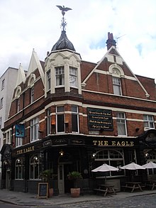
The Royal Grecian Theatre was a music hall theatre, located in the grounds of the Eagle Tavern, a public house at Shepherdess Walk, just off the City Road in Shoreditch, in the East End of London. The Eagle, best known for its association with the nursery rhyme Pop goes the weasel survives, but the theatre does not.