City of Rockingham

Last updated

City of Rockingham
Western Australia
Rockingham LGA WA.png
The City of Rockingham within the Perth metropolitan area
Cityofrockinghamofficialcrest.jpg
City of Rockingham coat of arms
City of Rockingham
Population135,678 (LGA 2021) [1]
 • Density526.9/km2 (1,365/sq mi)
Established1897
Area257.5 km2 (99.4 sq mi) [2]
MayorDeb Hamblin
Council seat Rockingham
Region South Metropolitan Perth
State electorate(s) Rockingham, Warnbro, Kwinana, Darling Range
Federal division(s) Brand
Logo of the City of Rockingham.svg
Website City of Rockingham
LGAs around City of Rockingham:
Kwinana Serpentine-Jarrahdale
City of Rockingham Serpentine-Jarrahdale
Mandurah Murray

The City of Rockingham is a council and local government area, comprising the south coastal suburbs of the Western Australian capital city of Perth.

Contents

History

Rockingham is located in the southern part of the traditional tribal territory of the Whadjuk, who form part of the Noongar language group.

Rockingham was named after the British ship Rockingham. [3]

In 1896, residents of Rockingham petitioned to establish a road board, which they proposed be called "Clarence" which was the name of the failed settlement of Thomas Peel at Woodman Point. The area at the time fell within the responsibility of the Fremantle District Road Board. The name "Clarence" was declined by the Department of Lands and Surveys, [4] :pp83-85 and the Rockingham Road District was gazetted on 4 February 1897. [5]

The agricultural hall on the corner of Flinders Lane and Kent Street in Rockingham was used for the Roads Board's administration until an office was constructed for the Roads Board on the corner of Office Road and Mandurah Road in East Rockingham in 1905. In 1929 the Board resolved to relocate the administration to Rockingham Beach and the various buildings, including the Agricultural Hall and the vacated Rockingham Beach Primary School building on Kent Street, were used as the Board's offices. [4]

A new office was constructed for the Roads Board in 1946 on the corner of Flinders Lane and Kent Street. [4]

In February 1954 the Kwinana Road District was formed from the northern portion of the Rockingham Road District.

On 1 July 1961, the Road District became the Shire of Rockingham following enactment of the Local Government Act 1960. [6] [7] In 1971, the Shire relocated to new offices on Council Avenue on land donated by developers Rockingham Park Pty Ltd 2 km southeast of the traditional centre of Rockingham Beach, which was to become the new major centre of Rockingham and Kwinana. The Rockingham City Shopping Centre opened in the new centre in 1971. Despite the move to the new "city centre," the community apparently considered Rockingham Beach to be the rightful civic heart of Rockingham, as evidenced by the Shire's decision to construct Flinders Hall on Flinders Lane, despite the new Council offices being constructed in the same year. [4] :pp287-288

On 12 November 1988 the Council attained City status. [6] [7] In 1994, the City relocated to new Council chambers and civic centre on Civic Boulevard. [8]

In 2008, the Council adopted a plan for the Rockingham Strategic Regional (or Primary) Centre which incorporated both the traditional centre at Rockingham Beach and the "City Centre" of the 1970s into a larger, encompassing centre. The plan seeks to increase the residential population within this new city centre envelope from 12,000 to 36,000 through the provision of transit-oriented development, which would in turn support the operation of light rail between the Rockingham Train Station and Rockingham Beach. [9]

Wards and mayor

The Rockingham council chambers Rockingham council chambers, July 2019 02.jpg
The Rockingham council chambers

The city has been divided into four wards.

Historically, the mayor was elected from among the councillors. The election system was changed for the 2021 council election, with the mayor directly elected. Deb Hamblin succeeded retiring Barry Sammels as mayor of the City of Rockingham, becoming the first female to hold this position. [10] Hamblin was officially sworn in on 19 October 2021 for a four-year term. [11]

At the time of the announcement of his retirement in August 2021, Barry Sammels had been the longest-serving active mayor in Western Australia, having first been elected mayor of Rockingham in 2003. Previous to this, he had been elected as a councillor in 1997 and as the deputy mayor in 2001. [12] [13]

Of the current councillors, Leigh Liley is the longest-serving, having first been elected to the council in 1999, while the current mayor, Deb Hamblin, served on the council from 2005 until her election to mayor. [14]

Current council composition:

PositionNameTerm
MayorDeb Hamblin2021–25
Deputy mayorLorna Buchan2023–25
Rockingham/Safety Bay WardPeter Hudson2023–27
Craig Buchanan2023–27
Mark Jones2023–27
Caroline Hume2021–25
Leigh Liley2021–25
Dawn Jecks2021–25
Baldivis WardMike Crichton2023–27
Kelly Middlecoat2023–27
Brett Wormall2021–25
Comet Bay WardLorna Buchan2023–27
Robert Schmidt2021–25

Election results

2023

Baldivis

2023 Western Australian local elections: Baldivis Ward [15] [16]
PartyCandidateVotes%±%
Christians Mike Crichton (elected)1,77724.43+24.43
Independent Kelly Middlecoat (elected)1,77024.33
Labor Lucas Martin1,05814.54
Independent Dylan Mbano81911.26
Independent Sally Davies6809.35
Independent Rebecca Privilege6749.26
Turnout 7,36230.57
Christians gain from Independent Swing N/A
Independent hold Swing N/A

Comet Bay

2023 Western Australian local elections: Comet Bay Ward [15]
PartyCandidateVotes%±%
Independent Lorna Buchan (elected)3,33364.68
Independent David Rudman1,05120.40
Independent Nic Nolan76914.92
Turnout 5,19832.18
Independent hold Swing N/A

Rockingham/Safety Bay

2023 Western Australian local elections: Rockingham/Safety Bay Ward [15]
PartyCandidateVotes%±%
Independent Liberal Mark Jones (elected)3,04819.48
Independent Liberal Peter Hudson (elected)2,81518.00
Legalise Cannabis Craig Buchanan (elected)1,92412.30
Legalise Cannabis Rae Cottam1,71410.96
Independent Adelle Hemingway1,4509.27
Independent Kingsley Klau1,1707.48
Independent Jason Davies9766.24
Independent Davina Reid7544.82
Independent Dawn Palmer6554.19
Independent Dean Bradley6274.01
Independent Brett Garner5103.26
Turnout 15,64329.98
Independent Liberal win Swing N/A
Independent Liberal gain from Legalise Cannabis Swing N/A
Legalise Cannabis hold Swing N/A

Suburbs

The suburbs of the City of Rockingham with population and size figures based on the most recent Australian census: [17] [18]

SuburbPopulationAreaMap
Baldivis 37,697 (SAL 2021 ) [19] 87.3 km2 (33.7 sq mi) City of Rockingham
Cooloongup 6,696 (SAL 2021 ) [20] 11.9 km2 (4.6 sq mi) City of Rockingham
East Rockingham 311 (SAL 2021 ) [21] 8.8 km2 (3.4 sq mi) City of Rockingham
Garden Island 772 (SAL 2021 ) [22] 11 km2 (4.2 sq mi) City of Rockingham
Golden Bay 5,681 (SAL 2021 ) [23] 4.45 km2 (1.72 sq mi) City of Rockingham
Hillman 1,807 (SAL 2021 ) [24] 1.2 km2 (0.46 sq mi) City of Rockingham
Karnup 2,096 (SAL 2021 ) [25] 32.2 km2 (12.4 sq mi) City of Rockingham
Keralup *0 (SAL 2021 ) [26] 40.3 km2 (15.6 sq mi) City of Rockingham
Peron 14 (SAL 2021 ) [27] 1.9 km2 (0.73 sq mi) City of Rockingham
Port Kennedy 13,477 (SAL 2021 ) [28] 21.2 km2 (8.2 sq mi) City of Rockingham
Rockingham 15,312 (SAL 2021 ) [29] [30] 12.8 km2 (4.9 sq mi) City of Rockingham
Safety Bay 7,662 (SAL 2021 ) [31] 4.6 km2 (1.8 sq mi) City of Rockingham
Secret Harbour 12,474 (SAL 2021 ) [32] 6.53 km2 (2.52 sq mi) City of Rockingham
Shoalwater 4,368 (SAL 2021 ) [33] 2.6 km2 (1.0 sq mi) City of Rockingham
Singleton 4,021 (SAL 2021 ) [34] 3.6 km2 (1.4 sq mi) City of Rockingham
Waikiki 12,453 (SAL 2021 ) [35] 10.2 km2 (3.9 sq mi) City of Rockingham
Warnbro 10,828 (SAL 2021 ) [36] 13.9 km2 (5.4 sq mi) City of Rockingham
* Indicates locality is only partially located within the City of Rockingham

Population

Historical population
YearPop.±% p.a.
1911 161    
1921 477+11.47%
1933 1,014+6.49%
1947 1,780+4.10%
1954 2,656+5.88%
1961 2,583−0.40%
1966 4,383+11.16%
1971 11,608+21.51%
1976 17,224+8.21%
YearPop.±% p.a.
1981 24,740+7.51%
1986 31,595+5.01%
1991 41,749+5.73%
1996 57,980+6.79%
2001 70,008+3.84%
2006 84,307+3.79%
2011 104,105+4.31%
2016 125,114+3.74%
2021 135,678+1.63%

In 1954, Kwinana was excised from Rockingham.

Media

Rockingham is serviced by two local newspapers: The Sound Telegraph is delivered every Wednesday, and the Weekend Courier on Fridays.

Conservation

Rockingham Lakes Regional Park, at 4,270 hectares, occupies approximately 16 percent of the area of the City of Rockingham. The park, established in 1997, consists of areas of land that have been identified as having outstanding conservation, landscape and recreation values. [37]

Heritage-listed places

As of 2024, 115 places are heritage-listed in the City of Rockingham, [38] of which seven are on the State Register of Heritage Places, among them Cape Peron K Battery Complex, the Bell Cottage ruin and Lake Richmond. [39]

Sport and recreation

Rockingham is home to the Rockingham Rams [40] in the Peel Football League; Rockingham Flames in NBL1 West; Rockingham City FC [41] in the National Premier Leagues WA; Rockingham Rams in the Harcher State Baseball League; Rockingham Rugby Union club in the RugbyWA competition; and the Rockingham Coastal Sharks in the Western Australia Rugby League.

Sister cities

The City of Rockingham has two active affiliations to which it is a signatory, being:

Related Research Articles

<span class="mw-page-title-main">City of Stirling</span> Local government area in Western Australia

The City of Stirling is a local government area in the northern suburbs of the Western Australian capital city of Perth about 10 kilometres (6 mi) north of Perth's central business district. The City covers an area of 105.2 square kilometres (40.6 sq mi) and has a population of over 223,000, making it the largest local government area by population in Western Australia.

<span class="mw-page-title-main">City of Bayswater</span> Local government area in Western Australia

The City of Bayswater is a local government area in the Western Australian capital city of Perth, about 7 kilometres (4 mi) northeast of Perth's central business district. The city covers an area of 34.6 square kilometres (13.4 sq mi) and had a population of 69,283 as at the 2021 Census. The City of Bayswater is a member of the Eastern Metropolitan Regional Council.

<span class="mw-page-title-main">City of Belmont</span> Local government area in Western Australia

The City of Belmont is a local government area in the inner eastern suburbs of the Western Australian capital city of Perth, located about 8 kilometres (5 mi) east of Perth's central business district on the south bank of the Swan River. The City covers an area of 39.8 square kilometres (15.4 sq mi), maintains 225 km of roads and had a population of almost 40,000 as at the 2016 Census.]

<span class="mw-page-title-main">City of Canning</span> Local government area in Western Australia

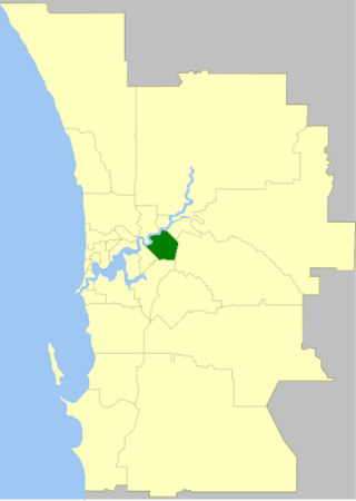
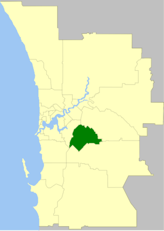
The City of Canning is a local government area in the southeastern suburbs of the Western Australian capital city of Perth, about 10 kilometres (6 mi) southeast of Perth's central business district. The City covers an area of 64.8 square kilometres (25.0 sq mi) and had a population of approximately 90,000 as at the 2016 Census.

<span class="mw-page-title-main">City of Cockburn</span> Local government area in Western Australia

The City of Cockburn is a local government area in the southern suburbs of the Western Australian capital city of Perth about 8 kilometres (5 mi) south of Fremantle and about 24 kilometres (15 mi) south of Perth's central business district. The City covers an area of 167.5 square kilometres (64.7 sq mi) and had a population of over 104,000 as at the 2016 Census.

<span class="mw-page-title-main">City of Gosnells</span> Local government area in Perth, Western Australia

The City of Gosnells is a local government area in the southeastern suburbs of the Western Australian capital city of Perth, located northwest of Armadale and about 20 kilometres (12 mi) southeast of Perth's central business district. The City covers an area of 128 square kilometres (49.42 sq mi), a portion of which is state forest rising into the Darling Scarp to the east, and had a population of approximately 118,000 at the 2016 Census. The largest activity centre in the City is the Central Maddington shopping centre. District centres exist in the Gosnells town centre and Thornlie.

<span class="mw-page-title-main">City of Melville</span> Local government area in Western Australia

The City of Melville is a local government area in the southern suburbs of the Western Australian capital city of Perth, east of the port city of Fremantle and about 12 kilometres (7.5 mi) south of Perth's central business district. The City covers an area of 52.73 square kilometres (20.36 sq mi) and had a population of about 98,000 as at the 2016 Census.

<span class="mw-page-title-main">City of Kwinana</span> Local government area in Western Australia

The City of Kwinana is a local government area of Western Australia. It covers an area of approximately 118 square kilometres in metropolitan Perth, and lies about 38 km south of Perth central business district, via the Kwinana Freeway. Kwinana maintains 287 km of roads and had a population of almost 39,000 as at the 2016 Census.

<span class="mw-page-title-main">City of Swan</span> Local government area in Western Australia

The City of Swan is a local government area of Western Australia. It is in the eastern metropolitan region of Perth and includes the Swan Valley and 42 suburbs. It is centred approximately 20 km north-east of the Perth central business district. The City covers an area of 1,042 km² and had an estimated population of 155,653 in 2020.

<span class="mw-page-title-main">Town of Victoria Park</span> Local government area in Western Australia

The Town of Victoria Park is a local government area of Western Australia. It covers an area of 17.62 km² in metropolitan Perth, the capital of Western Australia. It had a population of approximately 35,000 as at the 2016 census.

<span class="mw-page-title-main">City of Vincent</span> Local government area in Western Australia

The City of Vincent is a local government area of Western Australia. It covers an area of approximately 10.4 square kilometres (4.0 sq mi) in metropolitan Perth, the capital of Western Australia, and lies about 3 km from the Perth CBD. The City of Vincent maintains 139 km of roads and 104 ha of parks and gardens. It had a population of over 33,000 at the 2016 Census.

<span class="mw-page-title-main">City of Wanneroo</span> Local government area in Western Australia

The City of Wanneroo is a local government area with city status in the northern suburbs of Perth, Western Australia. It is centred approximately 25 kilometres (15.5 mi) north of Perth's central business district and forms part of the northern boundary of the Perth metropolitan area. Wanneroo encompasses the federal divisions of Cowan, Moore and Pearce.

<span class="mw-page-title-main">City of Mandurah</span> Local government area in Western Australia

The City of Mandurah is a local government area of Western Australia, covering both Mandurah proper and an additional area reaching down as far south as Lake Clifton. The city has a total area of approximately 174 square kilometres (67 sq mi).

<span class="mw-page-title-main">Shire of Waroona</span> Local government area in Western Australia

The Shire of Waroona is a local government area in the Peel region of Western Australia between Mandurah and Harvey and about 110 kilometres (68 mi) south of Perth, the state capital. The Shire covers an area of about 835 km² (322 mi²) and its seat of government is the town of Waroona.

<span class="mw-page-title-main">City of Albany</span> Local government area in Western Australia

The City of Albany is a local government area in the Great Southern region of Western Australia, about 410 kilometres (255 mi) south-southeast of Perth, the capital of Western Australia. It covers an area of 4,312.3 square kilometres (1,665 sq mi), including the Greater Albany metropolitan area and the Port of Albany, as well as the surrounding agricultural district and some national parks. The City of Albany had a population of over 36,000 at the 2016 census.

<span class="mw-page-title-main">City of Armadale</span> Local government area in Western Australia

The City of Armadale is a local government area in the southeastern suburbs of the Western Australian capital city of Perth, about 28 kilometres (17.4 mi) southeast of Perth's central business district. The City covers an area of 560 square kilometres (216 sq mi), much of which is state forest rising into the Darling Scarp to the east, and had a population of almost 80,000 as at the 2016 Census.

<span class="mw-page-title-main">Shire of Dandaragan</span> Local government area in the Wheatbelt region of Western Australia

The Shire of Dandaragan is a local government area located in the Wheatbelt region of Western Australia, about 200 kilometres (124 mi) north of the state capital, Perth. The Shire covers an area of 6,716 square kilometres (2,593 sq mi) and its seat of government is the town of Jurien Bay.

<span class="mw-page-title-main">City of Fremantle</span> Local government area in Western Australia

The City of Fremantle is a local government area in the south of Perth, Western Australia. The City covers an area of 19.0 square kilometres (7.3 sq mi), and lies about 19 kilometres (12 mi) southwest of the Perth central business district.

<span class="mw-page-title-main">City of Kalgoorlie–Boulder</span> Local government area in Western Australia

The City of Kalgoorlie–Boulder is a local government area in the Goldfields–Esperance region of Western Australia, about 550 kilometres (342 mi) east of the state capital, Perth. Covering an area of 95,575 square kilometres (36,902 sq mi), the city is the 12th largest in the world, larger than the country of Portugal with a land area of 92,212 square kilometres (35,603 sq mi). Its seat of government is the town of Kalgoorlie; all but 244 of the city's population live in either Kalgoorlie or Boulder.

References

  1. Australian Bureau of Statistics (28 June 2022). "Rockingham (Local Government Area)". Australian Census 2021 QuickStats. Retrieved 28 June 2022.  OOjs UI icon edit-ltr-progressive.svg
  2. Australian Bureau of Statistics (28 June 2022). "2021 Community Profiles: Rockingham". 2021 Census of Population and Housing. Retrieved 10 July 2022. OOjs UI icon edit-ltr-progressive.svg
  3. Rockingham District Historical Society - History of Rockingham
  4. 1 2 3 4 Draper, Richard Rockingham – The Visions Unfold. City of Rockingham. 1997. ISBN   0-9599249-2-2
  5. "Rockingham Roads Board District (per 5980/96)". Western Australia Government Gazette. 4 February 1897. p. 1897:244.
  6. 1 2 "Local Government Act 1960. Shire of Rockingham (City Status) Order 1988". Western Australia Government Gazette. 10 June 1988. p. 1988:1934.
  7. 1 2 WA Electoral Commission, Municipality Boundary Amendments Register (release 3.0), 31 May 2007.
  8. Rockingham Municipal Heritage Inventory Archived 6 July 2011 at the Wayback Machine Palassis Architects, April 2008 p.22
  9. Rockingham Strategic Regional Centre Archived 8 April 2011 at the Wayback Machine
  10. Welhan, Monique (17 October 2021). "City of Mandurah, Rockingham 2021 election results". 97.3 Coast FM. Mandurah. Retrieved 19 October 2021.
  11. Cooper, Daniela (19 October 2021). "Deb Hamblin voted in as first-ever female mayor for Rockingham". Mandurah Mail. Mandurah. Retrieved 21 October 2021.
  12. Thompson, Holly (3 August 2021). "Sunset on Sammels' City reign". Sound Telegraph. Mandurah. Retrieved 19 October 2021.
  13. Welhan, Monique (2 August 2021). "End of an era for Rockingham Mayor Barry Sammels". 97.3 Coast FM. Mandurah. Retrieved 19 October 2021.
  14. City of Rockingham 1988 (Honour board). City of Rockingham council chambers: City of Rockingham. 2006. Retrieved 29 October 2021.
  15. 1 2 3 "2023 Ordinary Election - Rockingham". Western Australian Electoral Commission.
  16. "Local elections: City of Rockingham welcomes three new councillors". Sound Telegraph.
  17. "SLIP Map". maps.slip.wa.gov.au. Landgate . Retrieved 24 December 2022.
  18. "NationalMap". nationalmap.gov.au. Geoscience Australia . Retrieved 24 December 2022.
  19. Australian Bureau of Statistics (28 June 2022). "Baldivis (suburb and locality)". Australian Census 2021 QuickStats. Retrieved 28 June 2022.  OOjs UI icon edit-ltr-progressive.svg
  20. Australian Bureau of Statistics (28 June 2022). "Cooloongup (suburb and locality)". Australian Census 2021 QuickStats. Retrieved 28 June 2022.  OOjs UI icon edit-ltr-progressive.svg
  21. Australian Bureau of Statistics (28 June 2022). "East Rockingham (suburb and locality)". Australian Census 2021 QuickStats. Retrieved 28 June 2022.  OOjs UI icon edit-ltr-progressive.svg
  22. Australian Bureau of Statistics (28 June 2022). "Garden Island (WA) (suburb and locality)". Australian Census 2021 QuickStats. Retrieved 28 June 2022.  OOjs UI icon edit-ltr-progressive.svg
  23. Australian Bureau of Statistics (28 June 2022). "Golden Bay (suburb and locality)". Australian Census 2021 QuickStats. Retrieved 28 June 2022.  OOjs UI icon edit-ltr-progressive.svg
  24. Australian Bureau of Statistics (28 June 2022). "Hillman (suburb and locality)". Australian Census 2021 QuickStats. Retrieved 28 June 2022.  OOjs UI icon edit-ltr-progressive.svg
  25. Australian Bureau of Statistics (28 June 2022). "Karnup (suburb and locality)". Australian Census 2021 QuickStats. Retrieved 28 June 2022.  OOjs UI icon edit-ltr-progressive.svg
  26. Australian Bureau of Statistics (28 June 2022). "Keralup (suburb and locality)". Australian Census 2021 QuickStats. Retrieved 28 June 2022.  OOjs UI icon edit-ltr-progressive.svg
  27. Australian Bureau of Statistics (28 June 2022). "Peron (suburb and locality)". Australian Census 2021 QuickStats. Retrieved 28 June 2022.  OOjs UI icon edit-ltr-progressive.svg
  28. Australian Bureau of Statistics (28 June 2022). "Port Kennedy (suburb and locality)". Australian Census 2021 QuickStats. Retrieved 28 June 2022.  OOjs UI icon edit-ltr-progressive.svg
  29. Australian Bureau of Statistics (28 June 2022). "Rockingham (WA) (suburb and locality)". Australian Census 2021 QuickStats. Retrieved 29 June 2022.  OOjs UI icon edit-ltr-progressive.svg
  30. Australian Bureau of Statistics (28 June 2022). "Rockingham (WA) (suburb and locality)". Australian Census 2021 QuickStats. Retrieved 28 June 2022.  OOjs UI icon edit-ltr-progressive.svg
  31. Australian Bureau of Statistics (28 June 2022). "Safety Bay (suburb and locality)". Australian Census 2021 QuickStats. Retrieved 28 June 2022.  OOjs UI icon edit-ltr-progressive.svg
  32. Australian Bureau of Statistics (28 June 2022). "Secret Harbour (suburb and locality)". Australian Census 2021 QuickStats. Retrieved 28 June 2022.  OOjs UI icon edit-ltr-progressive.svg
  33. Australian Bureau of Statistics (28 June 2022). "Shoalwater (WA) (suburb and locality)". Australian Census 2021 QuickStats. Retrieved 28 June 2022.  OOjs UI icon edit-ltr-progressive.svg
  34. Australian Bureau of Statistics (28 June 2022). "Singleton (WA) (suburb and locality)". Australian Census 2021 QuickStats. Retrieved 28 June 2022.  OOjs UI icon edit-ltr-progressive.svg
  35. Australian Bureau of Statistics (28 June 2022). "Waikiki (suburb and locality)". Australian Census 2021 QuickStats. Retrieved 28 June 2022.  OOjs UI icon edit-ltr-progressive.svg
  36. Australian Bureau of Statistics (28 June 2022). "Warnbro (suburb and locality)". Australian Census 2021 QuickStats. Retrieved 28 June 2022.  OOjs UI icon edit-ltr-progressive.svg
  37. Rockingham Lakes Regional Park Management Plan 2010 (PDF) (Report). Conservation Commission of Western Australia, Department of Environment and Conservation & City of Rockingham. 2010. Retrieved 22 November 2019.
  38. "City of Rockingham Heritage Places". inherit.stateheritage.wa.gov.au. Heritage Council of Western Australia. Retrieved 25 February 2024.
  39. "City of Rockingham State Register of Heritage Places". inherit.stateheritage.wa.gov.au. Heritage Council of Western Australia. Retrieved 25 February 2024.
  40. "Welcome to Rockingham Rams". Archived from the original on 15 July 2011. Retrieved 6 April 2011.
  41. Rockingham City FC Archived 6 July 2011 at the Wayback Machine
  42. "WA-Japan Sister City Relationships ::: GOVERNMENT OF WESTERN AUSTRALIA". Ember Media Japan (in Japanese). Retrieved 15 December 2022.
  43. Archived 29 March 2011 at the Wayback Machine City of Rockingham Global Friendship Policy, adopted by Council at its ordinary meeting held on 28 September 2010

32°16′52″S115°43′37″E / 32.28111°S 115.72694°E / -32.28111; 115.72694