
Barge often refers to a flat-bottomed inland waterway vessel which does not have its own means of mechanical propulsion. The first modern barges were pulled by tugs, but on inland waterways, most are pushed by pusher boats, or other vessels. The term barge has a rich history, and therefore there are many other types of barges.

The Central Business District (CBD) is a neighborhood of the city of New Orleans, Louisiana, United States.

Bywater is a neighborhood of the city of New Orleans. A subdistrict of the Bywater District Area, its boundaries as defined by the City Planning Commission are: Florida Avenue to the north, the Industrial Canal to the east, the Mississippi River to the south, and the railroad tracks along Homer Plessy Way to the west. Bywater is part of the Ninth Ward of New Orleans. It includes part or all of Bywater Historic District, which is listed on the National Register of Historic Places.
The Mississippi River–Gulf Outlet Canal is a 76 mi (122 km) channel constructed by the United States Army Corps of Engineers at the direction of Congress in the mid-20th century that provided a shorter route between the Gulf of Mexico and New Orleans' inner harbor Industrial Canal via the Intracoastal Waterway. In 2005, the MRGO channeled Hurricane Katrina's storm surge into the heart of Greater New Orleans, contributing significantly to the subsequent multiple engineering failures experienced by the region's hurricane protection network. In the aftermath the channel was closed. A permanent storm surge barrier was constructed in the MRGO in 2009, and the channel has been closed to maritime shipping.

The Ninth Ward or 9th Ward is a distinctive region of New Orleans, Louisiana, which is located in the easternmost downriver portion of the city. It is geographically the largest of the 17 Wards of New Orleans. On the south, the Ninth Ward is bounded by the Mississippi River. On the western or "upriver" side, the Ninth Ward is bounded by Franklin Avenue, then Almonaster Avenue, then People's Avenue. From the north end of People's Avenue the boundary continues on a straight line north to Lake Pontchartrain; this line is the boundary between the Ninth and the city's Eighth Ward. The Lake forms the north and northeastern end of the ward. St. Bernard Parish is the boundary to the southeast, Lake Borgne farther southeast and east, and the end of Orleans Parish to the east at the Rigolets.

This article contains a historical timeline of the events of Hurricane Katrina on August 23–30, 2005 and its aftermath.

The Industrial Canal is a 5.5 mile (9 km) waterway in New Orleans, Louisiana, United States. The waterway's proper name, as used by the U.S. Army Corps of Engineers and on NOAA nautical charts, is Inner Harbor Navigation Canal (IHNC). The more common "Industrial Canal" name is used locally, both by commercial mariners and by landside residents.

The 17th Street Canal is the largest and most important drainage canal in the city of New Orleans. Operating with Pump Station 6, it moves water into Lake Pontchartrain. The canal, along with the Orleans Canal and the London Avenue Canal, form the New Orleans Outfall Canals. The 17th Street Canal forms a significant portion of the boundary between the city of New Orleans and Metairie, Louisiana. The canal has also been known as the Metairie Outlet Canal and the Upperline Canal.
Though Hurricane Katrina did not deal the city of New Orleans a direct hit on August 29, 2005, the associated storm surge precipitated catastrophic failures of the levees and flood walls. The Mississippi River Gulf Outlet ("MR-GO") breached its levees in approximately 15 places. The major levee breaches in the city include the 17th Street Canal levee, the London Avenue Canal, and the wide, navigable Industrial Canal, which left approximately 80% of the city flooded.

The Lower Ninth Ward is a neighborhood in the city of New Orleans, Louisiana. As the name implies, it is part of the 9th Ward of New Orleans. The Lower Ninth Ward is often thought of as the entire area within New Orleans downriver of the Industrial Canal; however, the City Planning Commission divides this area into the Lower Ninth Ward and Holy Cross neighborhoods.
On Monday, August 29, 2005, there were over 50 failures of the levees and flood walls protecting New Orleans, Louisiana, and its suburbs following passage of Hurricane Katrina. The failures caused flooding in 80% of New Orleans and all of St. Bernard Parish. In New Orleans alone, 134,000 housing units — 70% of all occupied units — suffered damage from Hurricane Katrina and the subsequent flooding.

The Florida Avenue Bridge is a vertical lift bridge spanning the Industrial Canal in New Orleans, Louisiana. The bridge has one railroad track, two vehicle lanes and two sidewalks. A parallel high-elevation four-lane roadway bridge is planned.

ING 4727 was a barge belonging to Ingram Barge Company that became infamous when it went over or through a levee and landed in a residential neighborhood of New Orleans, Louisiana during Hurricane Katrina.

The 17th Ward is one of the 17 Wards of New Orleans, a section of the city of New Orleans, Louisiana. New Orleans Districts and Wards. The 17th Ward, along with the 16th, was formed when the City of New Orleans annexed City of Carrollton in 1870.

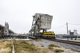
The Inner Harbor Navigation Canal Lock—commonly known as Industrial Canal Lock or simply Industrial Lock—is a navigation lock in New Orleans. It connects the Lower Mississippi River to the Industrial Canal and other sea-level waterways. Because it is shorter and narrower than most modern locks on the Mississippi River System, the 1920s vintage lock has become a bottleneck between the nation's two highest-tonnage waterways—the Mississippi and the Gulf Intracoastal Waterway.
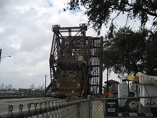
The St. Claude Avenue Bridge is a bascule bridge with four vehicular lanes over the Industrial Canal in New Orleans, Louisiana. The bridge was designed by the Strauss Bascule Bridge Company of Chicago and built in 1919 by the Bethlehem Steel Bridge Corporation. It was originally a combination railroad and automobile bridge, with two pairs of railroad tracks in the center of the lift span and automobile lanes straddling it. The railroad is no longer there, its place on the bridge taken by additional vehicular lanes. One lane in each direction passes through the truss of the bridge and one lane passes alongside the truss. The bridge is integrated into the Industrial Canal Lock structure, on the river side of the lock chamber; it raises when marine traffic enters or exits the lock.

The Almonaster Avenue Bridge is a bascule bridge in New Orleans, Louisiana. The bridge has two vehicular lanes of Almonaster Avenue and two railroad tracks over the Industrial Canal.
The Seabrook Railroad Bridge is a bascule bridge in New Orleans, Louisiana running adjacent to the Seabrook Bridge. It is often confused with this vehicular bridge to the north, officially called the Senator Ted Hickey Bridge; therefore, it is commonly called the Seabrook Railroad Bridge, that now carries only trains across the canal. The bridge has a horizontal clearance of 79 feet (24 m) with unlimited vertical clearance when fully retracted.

Claiborne Avenue is a major thoroughfare in New Orleans, Louisiana. It runs the length of the city, about 9.5 miles (15.3 km), beginning at the Jefferson Parish line and ending at the St. Bernard Parish line; the street continues under different names in both directions. It is called South Claiborne Avenue upriver from Canal Street and North Claiborne Avenue from Canal to St. Bernard Parish.

USNS Courier was a cargo ship of the National Defense Reserve Fleet. The cargo ship was built by Sun Shipbuilding and Drydock Company, Chester, Pennsylvania, at the request of the US Maritime Administration in 1962. The ship was 470 ft in length and has a breath of 73 and weighs 11420 tons, empty. The ship was originally administered by American Export Lines under the civilian name SS Export Courier and eventually became part of the James River Reserve Fleet. The company ran into financial trouble in 1977. Before 1981, Farrell Lines, which took over parts of the dissolved American Export Lines, transferred administration of the Courier to the Military Sealift Command, which renamed the ship USNS Courier. The ship was officially accepted as part of the Maritime Administration in February 1983. From 1981 it was stationed with the Beaumont Reserve Fleet or docked at Port Neches, Beaumont Texas. Service records indicate repairs after Operation Desert Storm. In 2001 the ship was transferred to the National Defense Reserve Fleet and remained in this status until July 2008 when it was sold to Southern Scrap Metal Corporation of New Orleans, Louisiana and subsequently transferred to New Orleans' Industrial Canal on 13 August, a little more than two weeks before Hurricane Gustav reached Louisiana's southeastern coast.


