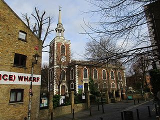
Rotherhithe is a residential district in south-east London, England, and part of the London Borough of Southwark. Historically the area was the most northeastern settlement in the county of Surrey. It is on a peninsula on the south bank of the Thames, facing Wapping, Shadwell and Limehouse on the north bank, as well as the Isle of Dogs to the east of the Thames and is a part of the Docklands area. It borders Bermondsey to the west and Deptford to the south east.

Wadhurst is a market town in East Sussex, England. It is the centre of the civil parish of Wadhurst, which also includes the hamlets of Cousley Wood and Tidebrook. Wadhurst is twinned with Aubers in France.

Edenbridge is a town and civil parish in the Sevenoaks district of Kent, England. Its name derives from Old English Eadhelmsbrigge. It is located on the Kent /Surrey border on the upper floodplain of the River Medway and gives its name to the latter's tributary, the River Eden. The town has a population of around 7,808.
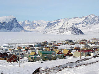
Pangnirtung is an Inuit hamlet, in the Qikiqtaaluk Region of the Canadian territory of Nunavut, located on Baffin Island. Pangnirtung is situated on a coastal plain at the coast of Pangnirtung Fjord, a fjord which eventually merges with Cumberland Sound. As of January 2022, the mayor is Stevie Komoartok.

Andros Island is an archipelago within the Bahamas, the largest of the Bahamian Islands. Politically considered a single island, Andros in total has an area greater than all the other 700 Bahamian islands combined. The land area of Andros consists of hundreds of small islets and cays connected by mangrove estuaries and tidal swamplands, together with three major islands: North Andros, Mangrove Cay, and South Andros. The three main islands are separated by "bights", estuaries that trifurcate the island from east to west. It is 167 kilometres (104 mi) long by 64 km (40 mi) wide at the widest point.
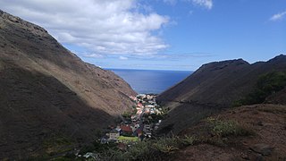
Jamestown is the capital city of the British Overseas Territory of Saint Helena, Ascension and Tristan da Cunha, located on the island of Saint Helena in the South Atlantic Ocean. It is also the historic main settlement of the island and is on its north-western coast. Before the development of the port at Rupert's Bay, it was the island's only port and the centre of the island's road and communications network. It was founded when colonists from the English East India Company settled on the island in 1659 and was briefly occupied by the Dutch East India Company in 1673 before being recaptured. Many of the buildings built by the East India Company in the 18th century survive and give the town its distinctive Georgian flavour.

The Abaco Islands lie in the northern Bahamas. The main islands are Great Abaco and Little Abaco. There are several smaller barrier cays, of which the northernmost are Walker's Cay and its sister island Grand Cay. To the south, the next inhabited islands are Spanish Cay and Green Turtle Cay, with its settlement of New Plymouth, Great Guana Cay, private Scotland Cay, Man-O-War Cay, and Elbow Cay, with its settlement of Hope Town. Southernmost are Tilloo Cay and Lubbers Quarters. Another of note off Abaco's western shore is Gorda Cay, now a Disney-owned island and a cruise ship stop renamed Castaway Cay. Also in the vicinity is Moore's Island. On the Big Island of Abaco is Marsh Harbour, the Abacos' commercial hub and the Bahamas' third largest city, plus the resort area of Treasure Cay. Both have airports. A few mainland settlements of significance are Coopers Town and Fox Town in the north and Cherokee and Sandy Point in the south. Administratively, the Abaco Islands constitute seven of the 31 Local Government Districts of the Bahamas: Grand Cay, North Abaco, Green Turtle Cay, Central Abaco, South Abaco, Moore's Island, and Hope Town.

Deer Lake is a town in the western part of the island of Newfoundland in the province of Newfoundland and Labrador, Canada.

Eleuthera refers both to a single island in the archipelagic state of The Commonwealth of the Bahamas and to its associated group of smaller islands. Eleuthera forms a part of the Great Bahama Bank. The island of Eleuthera incorporates the smaller Harbour Island. "Eleuthera" derives from the feminine form of the Greek adjective ἐλεύθερος (eleútheros), meaning "free". Known in the 17th century as Cigateo, it lies 80 km east of Nassau. It is long and thin—180 km long and in places little more than 1.6 km wide. Its eastern side faces the Atlantic Ocean, and its western side faces the Great Bahama Bank. The topography of the island varies from wide rolling pink sand beaches to large outcrops of ancient coral reefs, and its population is approximately 11,000. The principal economy of the island is tourism.

Exuma is a district of The Bahamas, consisting of over 365 islands, also called cays.

Ragged Island is a small island 23 km2 (8.9 sq mi) and district in the southern Bahamas. Ragged Island is part of the Jumentos Cays and Ragged Island Chain. The crescent-shaped chain measures over 180 km (110 mi) in length and includes cays known as Raccoon Cay, Hog Cay and Double-Breasted Cay. Island ownership is stated to have been granted to William George Lockhart some time in the 1700s. On 8 September 2017, Duncan Town took a direct hit from Hurricane Irma.

Montreal West is an on-island suburb in southwestern Quebec, Canada, on the Island of Montreal.

South Andros is a district of the nation of the Bahamas.
Alberton is a Canadian town located in Prince County, Prince Edward Island. It is situated in the western part of the county in the township of Lot 5.

Hope Town is one of the districts of the Bahamas, on the Abaco islands as well as a small village on Elbow Cay, located in Abaco. The area had a population of 458 in 2010.

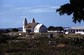
North Andros is one of the 31 districts of the Bahamas. It is also the largest district in the country. It has some of the largest settlements on Andros Island and many churches as well. The population is 3,898.

Spanish Wells is a district of the Bahamas. The settlement consists of a medium-sized town on the island of St. George's Cay 610 m (2,000 ft) wide by 2,860 m (9,380 ft) long, located approximately 500 m (1,600 ft) off the northern tip of Eleuthera island. According to the 2010 census, it has a population of 1,551 residents.
John Cyril Hawes was an architect and priest. Hawes was known for designing and constructing church buildings in England, Western Australia and The Bahamas. He served as a priest in the Church of England before converting to Roman Catholicism and received ordination as a Catholic priest. He was later named a Domestic Prelate by Pope Pius XI and given the title "monsignor". After retiring he lived as a hermit in The Bahamas, becoming known more commonly as Father Jerome.
The Church in the Province of the West Indies is one of 40 member provinces in the worldwide Anglican Communion. The church comprises eight dioceses spread out over much of the West Indies area. The present position of Archbishop and Primate of the West Indies is held by the current bishop of Jamaica, Howard Gregory. Gregory was elected as the thirteenth Archbishop of the Province by clergy and laity attending the 40th Synod of the CPWI at the Cascadia Hotel, in Port of Spain, Trinidad in May 2019. The position was previously held by John Holder who retired in 2018. Drexel Gomez was the primate before Bishop Holder until 2009. The church is also part of the Global South.

Long Island is an island in The Bahamas that is split by the Tropic of Cancer. It is one of the Districts of the Bahamas and is known as the most scenic island in the Bahamas. Its capital is Clarence Town. The population of Long Island is 3,094 inhabitants.