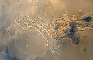
Noctis Labyrinthus is a region of Mars located in the Phoenicis Lacus quadrangle, between Valles Marineris and the Tharsis upland. The region is notable for its maze-like system of deep, steep-walled valleys. The valleys and canyons of this region formed by faulting and many show classic features of grabens, with the upland plain surface preserved on the valley floor. In some places the valley floors are rougher, disturbed by landslides, and there are places where the land appears to have sunk down into pit-like formations. It is thought that this faulting was triggered by volcanic activity in the Tharsis region. Research described in December 2009 found a variety of minerals, including clays, sulfates, and hydrated silicas, in some of the layers.
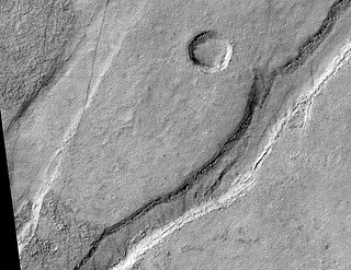
In planetary nomenclature, a fossa is a long, narrow depression (trough) on the surface of an extraterrestrial body, such as a planet or moon. The term, which means "ditch" or "trench" in Latin, is not a geological term as such but a descriptor term used by the United States Geological Survey (USGS) and the International Astronomical Union (IAU) for topographic features whose geology or geomorphology is uncertain due to lack of data or knowledge of the exact processes that formed them. Fossae are believed to be the result of a number of geological processes, such as faulting or subsidence. Many fossae on Mars are probably graben.

The Memnonia quadrangle is one of a series of 30 quadrangle maps of Mars used by the United States Geological Survey (USGS) Astrogeology Research Program. The Memnonia quadrangle is also referred to as MC-16.

Tempe Terra is a heavily cratered highland region in the northern hemisphere of the planet Mars. Located at the northeastern edge of the Tharsis volcanic province, Tempe Terra is notable for its high degree of crustal fracturing and deformation. The region also contains many small shield volcanoes, lava flows, and other volcanic structures.

The Arcadia quadrangle is one of a series of 30 quadrangle maps of Mars used by the United States Geological Survey (USGS) Astrogeology Research Program. The quadrangle is located in the north-central portion of Mars’ western hemisphere and covers 240° to 300° east longitude and 30° to 65° north latitude. The quadrangle uses a Lambert conformal conic projection at a nominal scale of 1:5,000,000 (1:5M). The Arcadia quadrangle is also referred to as MC-3.

The Elysium quadrangle is one of a series of 30 quadrangle maps of Mars used by the United States Geological Survey (USGS) Astrogeology Research Program. The Elysium quadrangle is also referred to as MC-15.

The Tharsis quadrangle is one of a series of 30 quadrangle maps of Mars used by the United States Geological Survey (USGS) Astrogeology Research Program. The Tharsis quadrangle is also referred to as MC-9 . The name Tharsis refers to a land mentioned in the Bible. It may be at the location of the old town of Tartessus at the mouth of Guadalquivir.

The Mare Tyrrhenum quadrangle is one of a series of 30 quadrangle maps of Mars used by the United States Geological Survey (USGS) Astrogeology Research Program. This quadrangle is also referred to as MC-22. It contains parts of the regions Tyrrhena Terra, Hesperia Planum, and Terra Cimmeria.

The Phoenicis Lacus quadrangle is one of a series of 30 quadrangle maps of Mars used by the United States Geological Survey (USGS) Astrogeology Research Program. The Phoenicis Lacus quadrangle is also referred to as MC-17. Parts of Daedalia Planum, Sinai Planum, and Solis Planum are found in this quadrangle. Phoenicis Lacus is named after the phoenix which according to myth burns itself up every 500 years and then is reborn.

The Ceraunius Fossae are a set of fractures in the northern Tharsis region of Mars. They lie directly south of the large volcano Alba Mons and consist of numerous parallel faults and tension cracks that deform the ancient highland crust. In places, younger lava flows cover the fractured terrain, dividing it into several large patches or islands. They are found in the Tharsis quadrangle.

The Ulysses Fossae are a group of troughs in the Tharsis quadrangle of Mars at 10.06° north latitude and 123.07° west longitude. They were named after an albedo feature name. The area contains pitted cones called Ulysses Colles which were interpreted to be possible Martian equivalents to terrestrial cinder cones.

The Olympica Fossae are a set of troughs in the Tharsis quadrangle of Mars at 25° north latitude and 114.1° west longitude. They are about 420 km long and were named after an albedo feature at 17N, 134W. Parts of the fossae have been suggested to be both outflow channels as well as channels for flowing lava, routing both molten rock and catastrophic outburst floods of water at different times in Mars' geological past.
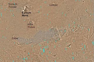
The Elysium Fossae are a group of large troughs in the Elysium quadrangle of Mars at 24.8° north latitude and 213.7° west longitude. They are about 1,175 km long and are named after a classical albedo feature name.

The Tempe Fossae are a group of troughs in the Arcadia quadrangle of Mars, located at 40.2° north latitude and 71.4° west longitude. They are about 2,000 km long and were named after an albedo feature at 40N, 70W.

The Tractus Fossae are a set of troughs in the Tharsis quadrangle of Mars, located at 26° north latitude and 101.4° west longitude. They are 390 km (240 mi) long and are named after a classical albedo feature name. The term "fossae" is used to indicate large troughs when using geographical terminology related to Mars. Troughs, sometimes also called grabens, form when the crust is stretched until it breaks, which forms two breaks with a middle section moving down, leaving steep cliffs along the sides. Sometimes, a line of pits form as materials collapse into a void that forms from the stretching.

Sirenum Fossae is a long trough in several quadrangles including Memnonia quadrangle and Phaethontis quadrangle of Mars, centered at 35.57° south latitude and 197.26° west longitude. Sirenum Fossae is 2,735 km long and was named after a classical albedo feature name. Troughs on Mars like this one are called Fossae. Sirenum Fossae is believed to have formed by movement along a pair of faults causing a center section to drop down. This kind of feature is called a graben.

Acheron Fossae is a trough in the Diacria quadrangle of Mars. Its location is centered at 37.67° north latitude and 135.87° west longitude. It is 718 km long and is named after a classical albedo feature at 35°N, 140°W. The trough has seen intensive tectonic activity in the past. Despite its crescent shape similar to the nearby aureole surrounding Olympus Mons, it is unrelated to them and predates the aureole which are Amazonian in age while Acheron is Hesperian in age.
Icaria Fossae is a trough in the Phaethontis quadrangle of Mars with its location centered at 46.4° south latitude and 123.8° west longitude. It is 280 km long and was named after an albedo feature at 44S, 130W.

Oti Fossae is a group of fossae (troughs) in the Phoenicis Lacus quadrangle on Mars, located at 9.3° S and 116.8° W. It is 370 km long and was named after a classical albedo feature.
The Amenthes Fossae are a system of troughs in the Amenthes quadrangle of Mars centered at 9.07°N and 102.68°E. They are 850 km across and were named after a classical albedo feature. The classical albedo feature name was based on the Egyptian name for a place where souls of the dead go. The name Amenthes Fossae was approved in 1976.

