Clarksburg, California

Last updated
Clarksburg
USA California location map.svg
Red pog.svg
Clarksburg
Location in California
Coordinates: 38°25′14″N121°31′38″W / 38.42056°N 121.52722°W / 38.42056; -121.52722 Coordinates: 38°25′14″N121°31′38″W / 38.42056°N 121.52722°W / 38.42056; -121.52722
Country Flag of the United States.svg  United States
State Flag of California.svg  California
County Yolo County
Area
[1]
  Total2.03 sq mi (5.26 km2)
  Land2.03 sq mi (5.26 km2)
  Water0.00 sq mi (0.00 km2)  0%
Elevation
[2]
10 ft (3 m)
Population
 (2020)
  Total402
  Density198.13/sq mi (76.48/km2)
ZIP code
95612
Area code 916, 279
FIPS code 06-13784
GNIS feature IDs 221173, 2582974

Clarksburg (formerly, Clarksburgh) [3] is a census-designated place in Yolo County, California. It is located on the Sacramento River, in the extreme southeastern corner of the county. It lies at an elevation of 10 feet (3 m) in ZIP code 95612 and area codes 916 and 279.

Contents

Geography

According to the United States Census Bureau, the CDP covers an area of 2.0 square miles (5.3 km2), all of it land.

Climate

According to the Köppen Climate Classification system, Clarksburg has a warm-summer Mediterranean climate, abbreviated "Csa" on climate maps. [4]

Climate data for Clarksburg, California (1935–1974)
MonthJanFebMarAprMayJunJulAugSepOctNovDecYear
Average high °F (°C)52.5
(11.4)
58.9
(14.9)
64.5
(18.1)
71.3
(21.8)
78.3
(25.7)
85.4
(29.7)
90.6
(32.6)
89.9
(32.2)
86.9
(30.5)
76.9
(24.9)
63.9
(17.7)
53.8
(12.1)
72.7
(22.6)
Average low °F (°C)35.6
(2.0)
38.9
(3.8)
41.5
(5.3)
45.0
(7.2)
49.2
(9.6)
53.5
(11.9)
56.0
(13.3)
55.0
(12.8)
52.9
(11.6)
46.8
(8.2)
39.4
(4.1)
36.3
(2.4)
45.8
(7.7)
Average precipitation inches (mm)3.84
(98)
3.00
(76)
2.15
(55)
1.39
(35)
0.37
(9.4)
0.12
(3.0)
0.01
(0.25)
0.02
(0.51)
0.20
(5.1)
1.03
(26)
2.09
(53)
3.15
(80)
17.37
(441)
Average precipitation days (≥ 0.01 in)98852100136952
Source: WRCC [5]

Demographics

Historical population
CensusPop.Note
2020 402
U.S. Decennial Census [6]

The 2010 United States Census [7] reported that Clarksburg had a population of 418. The population density was 206.0 inhabitants per square mile (79.5/km2). The racial makeup of Clarksburg was 339 (81.1%) White, 2 (0.5%) African American, 2 (0.5%) Native American, 16 (3.8%) Asian, 1 (0.2%) Pacific Islander, 37 (8.9%) from other races, and 21 (5.0%) from two or more races. Hispanic or Latino of any race were 109 persons (26.1%).

The Census reported that 418 people (100% of the population) lived in households, 0 (0%) lived in non-institutionalized group quarters, and 0 (0%) were institutionalized.

There were 168 households, out of which 51 (30.4%) had children under the age of 18 living in them, 102 (60.7%) were opposite-sex married couples living together, 11 (6.5%) had a female householder with no husband present, 10 (6.0%) had a male householder with no wife present. There were 4 (2.4%) unmarried opposite-sex partnerships, and 1 (0.6%) same-sex married couples or partnerships. 40 households (23.8%) were made up of individuals, and 14 (8.3%) had someone living alone who was 65 years of age or older. The average household size was 2.49. There were 123 families (73.2% of all households); the average family size was 2.96.

The population was spread out, with 96 people (23.0%) under the age of 18, 27 people (6.5%) aged 18 to 24, 63 people (15.1%) aged 25 to 44, 140 people (33.5%) aged 45 to 64, and 92 people (22.0%) who were 65 years of age or older. The median age was 48.7 years. For every 100 females, there were 98.1 males. For every 100 females age 18 and over, there were 89.4 males.

There were 182 housing units at an average density of 89.7 per square mile (34.6/km2), of which 115 (68.5%) were owner-occupied, and 53 (31.5%) were occupied by renters. The homeowner vacancy rate was 0%; the rental vacancy rate was 10.0%. 270 people (64.6% of the population) lived in owner-occupied housing units and 148 people (35.4%) lived in rental housing units.

History

Clarksburg has been settled in stages dating back as early as the 1850s when Merritt Island was first cleared and developed for agricultural uses. Postal authorities first established a post office in 1876, under the name "Clarksburgh" and changed the name to "Clarksburg" in 1893. [3] The town was named after Robert C. Clark who settled at the place in 1849. [3] In the 1920s the New Holland Land Company began subdividing the tracts in the area and formally established Clarksburg as an unincorporated community. Clarksburg is unique among small California towns in that many of the families who initially settled the area are still present, thus lending a small-town charm to the community.[ according to whom? ]

Present day

The community is mostly centered on the two churches in town, the Holland Market, the volunteer fire department, the three schools, and the public library. The 1930s era Old Sugar Mill (which closed in 1988) is now the center of development with 125 new homes proposed for construction on the property. This will be the first significant development since the Old Sugar Mill was built in the 1930s. The project is currently stayed by the Delta Protection Commission until it is made compliant with their Resource and Management Plan.[ citation needed ] Appeals were made to this State of California commission by the Natural Resources Defense Council and the Concerned Citizens of Clarksburg. As of February 2008 the Old Sugar Mill development was involved in significant litigation. A portion of the original Old Sugar Mill is now home to a modern wine tasting and production facility.

The Bogle Winery on Merritt Island has become the most famous of the Clarksburg appellation vintners with their wines being sold worldwide and being served at the White House as of 2007.

The population in 2008 is approximately 300. This is an approximation as the community borders are undefined and opinions on what outlying areas are actually part of Clarksburg vary from one source to the next. The portion of Sacramento County directly across the Sacramento River was once considered part of the community due to the ferry crossing that existed at Clarksburg from 1920 until the Freeport Bridge opened on New Year's Day in 1930. The ferry itself sank in November, 1928. Some of the older members of the community still refer to that adjoining area of Sacramento County as Clarksburg for that reason.

There are three schools in Clarksburg: Delta Elementary Charter School, Clarksburg Middle School, and Delta High School. All three schools are a part of the River Delta Unified School District.

Architectural heritage

Architect William Raymond Yelland would spend summers in Clarksburg with family. W.R. Yelland designed several buildings in the town of Clarksburg including several homes, the Clarksburg Community Church, and the Sugar Mill. W.R. Yelland is most noted for his Arts and Crafts and Storybook Houses of the 1920s and 1930s.

Industry and agriculture

What few industries that exist in the area are mostly involved in supporting the agricultural concerns of the area. Agriculture in the area principally includes wine grapes, dichondra grass seed, and tomatoes. Alfalfa is also found to occur but it is not the principal crop as it was prior to the 1920s.

Events and culture

The Paul Reese Memorial Clarksburg Country Run occurs every November as it has since 1965 and includes a 20-mile (32 km) race, a half-marathon, a 5k fun run, and children's events.

The Friends of the Clarksburg Library sponsor The Wines of Clarksburg fundraiser every year to support the local library. The event is typically hosted at the New Holland Land Company's former site and the event is a good excuse to view this example of historic, California Delta architecture.

Notable people

Related Research Articles

<span class="mw-page-title-main">Durham, California</span> Census-designated place in California, United States

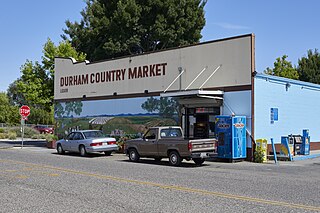
Durham is a census-designated place (CDP) in Butte County, California, United States. The population was 5,518 at the 2010 census.

<span class="mw-page-title-main">Gridley, California</span> City in California, United States

Gridley is a city in Butte County, California, United States, 29 miles south of Chico, California and 56 miles north of Sacramento, California. The 2019 State of California population estimate was 7,224. California State Route 99 runs through Gridley and Interstate 5 and California State Route 70 are both nearby. The highway CA 99 goes through Gridley and the current population is 9,082 [found in a recent census].

<span class="mw-page-title-main">Crockett, California</span> Census-designated place in California, United States

Crockett is a census-designated place (CDP) in Contra Costa County, in the East Bay sub-region of the San Francisco Bay Area, California. The population was 3,094 at the 2010 census. It is located 28 miles northeast of San Francisco. Other nearby communities include Port Costa, Martinez, Vallejo, Benicia, Rodeo, Hercules, Pinole and Richmond.

<span class="mw-page-title-main">Discovery Bay, California</span> Census-designated place in California, United States

Discovery Bay is a census-designated place (CDP) in eastern Contra Costa County, California in the United States, about 60 miles (97 km) from San Francisco. It is located in the San Francisco Bay Area. As of 2020, its population was 15,358, a 15% percent gain from 13,352 at the 2010 census.

<span class="mw-page-title-main">Pittsburg, California</span> City in California, United States

Pittsburg is a city in Contra Costa County, California, United States. It is an industrial suburb located on the southern shore of the Suisun Bay in the East Bay region of the San Francisco Bay Area, and is part of the Sacramento–San Joaquin River Delta area, the Eastern Contra Costa County area, and the San Francisco Bay Area. The population was 76,416 at the 2020 United States Census.

<span class="mw-page-title-main">Hamilton City, California</span> Census-designated place in California, United States

Hamilton City is a census-designated place (CDP) in Glenn County, California, United States. The population was 1,759 at the 2010 census, down from 1,903 at the 2000 census. Hamilton City is located 9.5 miles (15 km) east of Orland, and 10 miles west of Chico at an elevation of 151 feet. The community is inside area code 530. The default prefix used for wired telephones in the Hamilton City area is 826. The postal ZIP Code is 95951.

<span class="mw-page-title-main">Orland, California</span> City in California, United States

Orland is a city in Glenn County, California. The population was 7,291 at the 2010 census, up from 6,281 at the 2000 census, making Orland the most populous and fastest growing city in Glenn County. Orland is located 16 miles (26 km) north of Willows, at an elevation of 259 feet. Interstate 5, (north–south) passes west of the downtown area while State Route 32 (east–west) passes through downtown.

<span class="mw-page-title-main">Granite Bay, California</span> Census-designated place in California, United States

Granite Bay is a census-designated place (CDP) in Placer County, California, United States. It is part of the Sacramento–Arden-Arcade–Roseville Metropolitan Statistical Area. The population was 21,247 at the 2020 census, up from 20,402 at the 2010 census. The ZIP codes are 95746 and 95661. Granite Bay is a primarily residential suburb of Sacramento and is located just east of Roseville and west of Folsom Lake.

<span class="mw-page-title-main">Fair Oaks, California</span> Census designated place in California, United States

Fair Oaks is a census-designated place (CDP) in Sacramento County, California, United States. It is part of the Sacramento–Arden-Arcade–Roseville Metropolitan Statistical Area. The population was 32,514 at the 2020 census, up from 30,912 at the 2010 census. The Fair Oaks zip code is 95628 and its area codes are 916 and 279. It is bordered to the west by Carmichael, north by the city of Citrus Heights, to the east by Orangevale, and to the south by the American River.

<span class="mw-page-title-main">Folsom, California</span> City in California, United States

Folsom is a city in Sacramento County, California, United States. It is commonly known for Folsom State Prison, made famous in the song "Folsom Prison Blues" by Johnny Cash, as well as for Folsom Lake. The population was 80,454 at the 2020 census.

<span class="mw-page-title-main">Isleton, California</span> City in California, United States

Isleton is a city in Sacramento County, California, United States. The population was 804 at the 2010 census, down from 828 at the 2000 census. It is located on Andrus Island amid the slough wetlands of the Sacramento-San Joaquin River Delta, on the eastern edge of the Rio Vista Gas Field. The city has many preserved 19th-century era storefronts along its main street, some of which show distinct Chinese influences.

<span class="mw-page-title-main">Rancho Cordova, California</span> City in California, United States

Rancho Cordova is a city in Sacramento County, California, United States which was incorporated in 2003. It is part of the Sacramento Metropolitan Area. The population was 64,776 at the 2010 census. In 2010 and 2019, Rancho Cordova was named as a winner of the All-America City Award.

<span class="mw-page-title-main">Walnut Grove, California</span> Census-designated place in California, United States

Walnut Grove is a census-designated place (CDP) in Sacramento County, California, United States. It is part of the Sacramento–Arden-Arcade–Roseville Metropolitan Statistical Area. The population was 1,542 at the 2010 census, up from 669 at the 2000 census.

<span class="mw-page-title-main">Lodi, California</span> City in California, United States

Lodi is a city located in San Joaquin County, California, in the center portion of California's Central Valley. The population was 62,134 at the 2010 census.

<span class="mw-page-title-main">Anderson, California</span> City in California, United States

Anderson is a city in Shasta County, California, approximately 10 miles south of Redding. Its population is 11,323 as of the 2020 census, up from 9,932 from the 2010 census.

<span class="mw-page-title-main">Rio Vista, California</span> City in California, United States

Rio Vista is a city located in the eastern end of Solano County, California, in the Sacramento River Delta region of Northern California. The population was 7,360 at the 2010 census.

<span class="mw-page-title-main">Dunnigan, California</span> Census-designated place in California, United States

Dunnigan is a census-designated place in Yolo County, California on Interstate 5. The population was 1,416 at the 2010 census. Dunnigan's ZIP code is 95937 and its area code 530. It lies at an elevation of 69 feet.

Yolo is an unincorporated community and census-designated place in Yolo County, California. It is located 4.9 miles northwest of the county seat, Woodland and 24 miles northwest of the state capital of Sacramento. Yolo's ZIP Code is 95697 and its area code 530. It lies at an elevation of 82 feet. The population was 421 at the 2020 census.

Elverta is a census-designated place in Sacramento County, California. It is part of the Sacramento metropolitan area, which includes Sacramento, Arden-Arcade, and Roseville. It is about 20 miles (32 km) from Sacramento, 2.5 miles (4.0 km) from Rio Linda, 6 miles (9.7 km) from Roseville, and 8.0 miles (12.9 km) from Antelope. The population was 5,492 as of the 2010 census.

The Yocha Dehe Wintun Nation is a federally recognized tribe of Wintun people, specifically Patwin people or southern Wintun, in Yolo County, California. They were formerly known as the Rumsey Indian Rancheria of Wintun Indians of California.

References

  1. "2020 U.S. Gazetteer Files". United States Census Bureau. Retrieved October 30, 2021.
  2. U.S. Geological Survey Geographic Names Information System: Clarksburg, California
  3. 1 2 3 Durham, David L. (1998). California's Geographic Names: A Gazetteer of Historic and Modern Names of the State. Clovis, Calif.: Word Dancer Press. p. 466. ISBN   1-884995-14-4.
  4. Climate Summary for Clarksburg, California
  5. "CLARKSBURG, CALIFORNIA (041784)". Western Regional Climate Center . Retrieved October 4, 2022.
  6. "Census of Population and Housing". Census.gov. Retrieved June 4, 2016.
  7. "2010 Census Interactive Population Search: CA - Clarksburg CDP". U.S. Census Bureau. Archived from the original on July 15, 2014. Retrieved July 12, 2014.
  8. Sacramento Sports HOF. "Tony Eason". Sacsportshof.com. Retrieved 3 June 2022.