Related Research Articles

Central Park is an urban park between the Upper West Side and Upper East Side neighborhoods of Manhattan in New York City that was the first landscaped park in the United States. It is the sixth-largest park in the city, containing 843 acres (341 ha), and the most visited urban park in the United States, with an estimated 42 million visitors annually as of 2016.

Montgomery County is a county in the U.S. state of Tennessee. As of the 2020 United States census, the population was 220,069. The county seat is Clarksville. The county was created in 1796. Montgomery County is included in the Clarksville, TN–KY Metropolitan Statistical Area.
The State University of New York College of Environmental Science and Forestry (ESF) is a public research university in Syracuse, New York focused on the environment and natural resources. It is part of the State University of New York (SUNY) system. ESF is immediately adjacent to Syracuse University, within which it was founded, and with which it maintains a special relationship. It is classified among "R2: Doctoral Universities – High research activity".

The Taconic Mountains are a 150-mile-long sub-range of the Appalachian Mountains lying on the eastern border of New York State and adjacent New England. The range, which played a role in the history of geological science, is separated from the Berkshires and Green Mountains to the east by a series of valleys, principally those of the Housatonic River, Battenkill River and Otter Creek. The Taconics' highest point is Mount Equinox in Vermont at 3,840 feet (1,170 m); among many other summits are Dorset Mountain, Mount Greylock and Mount Everett.
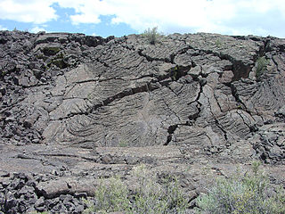
El Malpais National Monument is a National Monument located in western New Mexico, in the Southwestern United States. The name El Malpais is from the Spanish term Malpaís, meaning badlands, due to the extremely barren and dramatic volcanic field that covers much of the park's area.

The Mokelumne River is a 95-mile (153 km)-long river in northern California in the United States. The river flows west from a rugged portion of the central Sierra Nevada into the Central Valley and ultimately the Sacramento–San Joaquin River Delta, where it empties into the San Joaquin River-Stockton Deepwater Shipping Channel. Together with its main tributary, the Cosumnes River, the Mokelumne drains 2,143 square miles (5,550 km2) in parts of five California counties. Measured to its farthest source at the head of the North Fork, the river stretches for 157 miles (253 km).
Rome Sand Plains is a 15,000-acre (61 km2) pine barrens about five miles (8.0 km) west of the city center of Rome in Oneida County in central New York. It consists of a mosaic of sand dunes rising about 50 feet (15 m) above low peat bogs that lie between the dunes. The barrens are covered with mixed northern hardwood forests, meadows, and wetlands. About 4,000 acres (16 km2) are protected in conservation preserves. Pine barrens are typical of seacoasts; the Rome Sand Plains is one of only a handful of inland pine barrens remaining in the United States. A second inland pine barrens, the Albany Pine Bush, is also found in New York, located north and west of state's capital Albany.

The Central Park Conservancy is a private, nonprofit park conservancy that manages Central Park under a contract with the City of New York and NYC Parks. The conservancy employs most maintenance and operations staff in the park. It effectively oversees the work of both the private and public employees under the authority of the publicly appointed Central Park administrator, who reports to the parks commissioner and the conservancy's president.
The Archaeological Conservancy is a 501(c)(3) non-profit organization that acquires and preserves archaeological sites in the United States. Whereas nearly every other nation protects all archaeological sites within its borders as part of its national patrimony, in the United States archaeological resources on private land are the private property of the landowner. As a result, archaeological sites in the United States are subject to destruction by urban development and sprawl, mechanized agricultural and land-leveling, and commercial looting to fuel the antiquities trade. By the 1970s the extent of archaeological site loss was increasing recognized as a crisis for the scientific study of the nation's past.

Green Tree Mall is a shopping mall located in Clarksville, Indiana, United States. The mall is located off of I-65 about four miles north of downtown Louisville. It has a total area of 795,382 square feet (73,893 m2). It was named for a large boundary tree of considerable age that once stood at the location. Currently, there are more than 80 inline stores and 2 major anchor stores. The third anchor was Sears which closed on October 1, 2017. The mall is managed by Namdar Realty. Green Tree Mall is a retail anchor for the Clarksville area.

The Ramble and Lake are two geographic features of Central Park in Manhattan, New York City. Part of Frederick Law Olmsted and Calvert Vaux's 1857 Greensward Plan for Central Park, the features are located on the west side of the park between the 66th and 79th Street transverses.
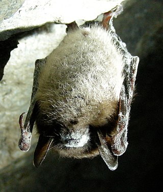
White-nose syndrome (WNS) is a fungal disease in North American bats which has resulted in the dramatic decrease of the bat population in the United States and Canada, reportedly killing millions as of 2018. The condition is named for a distinctive fungal growth around the muzzles and on the wings of hibernating bats. It was first identified from a February 2006 photo taken in a cave located in Schoharie County, New York. The syndrome has rapidly spread since then. In early 2018, it was identified in 33 U.S. states and seven Canadian provinces; plus the fungus, albeit sans syndrome, had been found in three additional states. Most cases are in the eastern half of both countries, but in March 2016, it was confirmed in a little brown bat in Washington state. In 2019, evidence of the fungus was detected in California for the first time, although no affected bats were found.

Black Pond Wildlife Management Area is a 526-acre (213 ha) New York State Wildlife Management Area (WMA) that lies on the eastern shore of Lake Ontario, and at the northern limit of an unusual region of sandy barrier beaches and lagoons. Much of the barrier beach in Black Pond WMA has forested sand dunes that are about 60 feet (18 m) high; these are the highest sand dunes in the northeast United States excepting Cape Cod. Immediately north of the WMA is the 360-acre (150 ha) El Dorado Beach Preserve, which is a bird refuge owned by The Nature Conservancy. North of the outlet from Black Pond to Lake Ontario, the shoreline is a weathered, flat bedrock shelf that is "calcareous" instead of sandy.
Wiss, Janney, Elstner Associates, Inc. (WJE) is an American corporation of architects, engineers, and materials scientists specializing in the investigation, analysis, testing, and design of repairs for historic and contemporary buildings and structures. Founded in 1956, WJE is headquartered in Northbrook, Illinois, and has over 600 professionals in twenty offices across the United States. WJE personnel are specialized in architectural, structural, and civil engineering; materials conservation, chemistry and petrography, and testing and instrumentation.
Clarksville is a hamlet in the town of New Scotland, Albany County, New York, United States. It is situated along Delaware Turnpike in the southern part of the town at the foot of the Helderberg Escarpment. It is the site of the Clarksville Cave and has an annual Clarksville Heritage Day and Car Show. It is in the Onesquethaw Volunteer Fire Company fire protection district.

Glacial Lake Albany was a prehistoric North American proglacial lake that formed during the end of the Wisconsinan glaciation. It existed between 15,000 and 12,600 years ago and was created when meltwater from a retreating glacier, along with water from rivers such as the Iromohawk, became ice dammed in the Hudson Valley. Organic materials in Lake Albany deposits have been carbon dated to approximately 11,700 years ago. The lake spanned approximately 160 miles (260 km) from present-day Poughkeepsie to Glens Falls.

Joppenbergh Mountain is a nearly 500-foot (152 m) mountain in Rosendale Village, a hamlet in the town of Rosendale, in Ulster County, New York. The mountain is composed of a carbonate bedrock overlain by glacially deposited material. It was named after Rosendale's founder, Jacob Rutsen, and mined throughout the late 19th century for dolomite that was used in the manufacture of natural cement. Extensive mining caused a large cave-in on December 19, 1899, that destroyed equipment and collapsed shafts within Joppenbergh. Though it was feared that several workers had been killed, the collapse happened while all the miners were outside, eating lunch. Since the collapse, the mountain has experienced shaking and periodic rockfalls.

North Woods and North Meadow are two interconnected features in the northern section of Central Park, New York City, close to the neighborhoods of the Upper West Side and Harlem in Manhattan. The 90-acre (36 ha) North Woods, in the northwestern corner of the park, is a rugged woodland that contains a forest called the Ravine, as well as two water features called the Loch and the Pool. The western portion of the North Woods also includes Great Hill, the third highest point in Central Park. North Meadow, a recreation center and sports complex, is immediately southeast of the North Woods. Completed in the 1860s, North Woods and North Meadow were among the last parts of Central Park to be built.
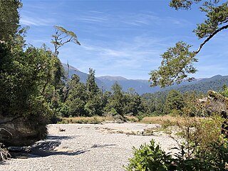
Bullock Creek or Punungairo is a river valley in the Paparoa National Park, located just north of Punakaiki on the West Coast of New Zealand. It includes a rare and nationally significant polje, a large, flat-floored depression within karst limestone. The Bullock Creek polje is New Zealand's only example of this type of landform.
References
- ↑ "Clarksville Cave". Northeastern Cave Conservancy. Archived from the original on 2011-07-26. Retrieved 2011-05-29.
- ↑ "Clarksville Cave Management Plan" (PDF). Northeastern Cave Conservancy. Archived from the original (PDF) on 2011-07-26. Retrieved 2011-05-29.
- ↑ "History of the Property" (PDF). Northeastern Cave Conservancy. Archived from the original (PDF) on 2011-07-26. Retrieved 2011-05-29.