Clayton, Louisiana

Last updated

Clayton, Louisiana
Town
Town of Clayton
Clayton, LA, cotton gin IMG 1225.JPG
Clayton Cotton Gin
Concordia Parish Louisiana Incorporated and Unincorporated areas Clayton Highlighted.svg
Location of Clayton in Concordia Parish, Louisiana.
Louisiana in United States (US48).svg
Location of Louisiana in the United States
Coordinates: 31°43′08″N91°32′20″W / 31.71889°N 91.53889°W / 31.71889; -91.53889
CountryUnited States
StateLouisiana
Parish Concordia
Government
Area
[1]
  Total1.64 sq mi (4.23 km2)
  Land1.58 sq mi (4.10 km2)
  Water0.05 sq mi (0.14 km2)
Elevation
56 ft (17 m)
Population
 (2020)
  Total584
  Density369.15/sq mi (142.55/km2)
Time zone UTC-6 (CST)
  Summer (DST) UTC-5 (CDT)
Area code 318
FIPS code 22-15850
Clayton welcome sign Clayton, LA, welcome sign IMG 0284.JPG
Clayton welcome sign

Clayton is a town in northern Concordia Parish, Louisiana, United States. The population was 711 at the 2010 census. [2] Cotton is a principal commodity in the area. Clayton is located on the Tensas River, important for fishing and boating, promoted through a U.S. Army Corps of Engineers-maintained boat launch. The Tensas River merges with the Black River in Jonesville in Catahoula Parish.

Contents

Louisiana State Representative Andy Anders is from Clayton and Ferriday.

Among the businesses in the community are Cross Keys Bank and David's Grocery.

A major employer in the town was Clayton Gin Company which closed in the early 2000s and was mostly demolished in the early 2010s. The Clayton Gin was originally constructed in the 1940s by W. Howard Davis and his brother Doyle E. Davis. The gin operated under the name "Davis Bros. Gin Co.". The last surviving brother, Howard Davis, died in 1972 and the gin continued to operate under the management of his son-in-law Sam D. Cole until his death in 1979. The gin was sold in the early 1980s and continued operation as the "Clayton Gin Company" until the early 2000s.

The Tensas River at Clayton, Louisiana Tensas River vertical lift bridge, Clayton, LA.jpg
The Tensas River at Clayton, Louisiana

Geography

Clayton is located in northern Concordia Parish at 31°43′8″N91°32′20″W / 31.71889°N 91.53889°W / 31.71889; -91.53889 (31.718837, -91.538902), [3] along the south bank of the Tensas River. Catahoula Parish is to the north across the river. U.S. Route 425 passes through the center of the town, leading north 36 miles (58 km) to Winnsboro and south 6 miles (10 km) to Ferriday and 18 miles (29 km) to Natchez, Mississippi. U.S. Route 65 has its southern terminus in Clayton; it leads north 56 miles (90 km) to Tallulah and 998 miles (1,606 km) to its northern terminus in Minnesota.

According to the United States Census Bureau, the town has a total area of 1.63 square miles (4.23 km2), of which 1.58 square miles (4.10 km2) is land and 0.05 square miles (0.14 km2), or 3.24%, is water. [2]

Demographics

Historical population
CensusPop.Note
1950 657
1960 88234.2%
1970 1,10325.1%
1980 1,2049.2%
1990 917−23.8%
2000 858−6.4%
2010 711−17.1%
2020 584−17.9%
U.S. Decennial Census [4]

2020 census

Clayton racial composition [5]
RaceNumberPercentage
White (non-Hispanic)14324.49%
Black or African American (non-Hispanic)42672.95%
Asian 10.17%
Other/Mixed 81.37%
Hispanic or Latino 61.03%

As of the 2020 United States census, there were 584 people, 189 households, and 107 families residing in the town.

2000 census

As of the census [6] of 2000, there were 858 people, 317 households, and 220 families residing in the town. The population density was 539.4 inhabitants per square mile (208.3/km2). There were 361 housing units at an average density of 226.9 per square mile (87.6/km2). The racial makeup of the town was 31.70% White, 67.25% African American, and 1.05% from two or more races. Hispanic or Latino of any race were 0.47% of the population.

There were 317 households, out of which 34.1% had children under the age of 18 living with them, 32.8% were married couples living together, 31.9% had a female householder with no husband present, and 30.3% were non-families. 24.9% of all households were made up of individuals, and 12.9% had someone living alone who was 65 years of age or older. The average household size was 2.71 and the average family size was 3.24.

In the town, the population was spread out, with 33.4% under the age of 18, 9.6% from 18 to 24, 21.7% from 25 to 44, 21.7% from 45 to 64, and 13.6% who were 65 years of age or older. The median age was 32 years. For every 100 females, there were 90.7 males. For every 100 females age 18 and over, there were 83.6 males.

The median income for a household in the town was $14,100, and the median income for a family was $15,598. Males had a median income of $22,250 versus $12,500 for females. The per capita income for the town was $7,955. About 38.9% of families and 45.3% of the population were below the poverty line, including 59.0% of those under age 18 and 34.9% of those age 65 or over.

Related Research Articles

<span class="mw-page-title-main">LaSalle Parish, Louisiana</span> Parish in Louisiana, United States

LaSalle Parish is a parish located in the U.S. state of Louisiana. As of the 2020 United States Census, the population was 14,791. The parish seat is Jena. The parish was created in 1910 from the western section of Catahoula Parish.

<span class="mw-page-title-main">Concordia Parish, Louisiana</span> Parish in Louisiana, United States

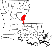
Concordia Parish borders the Mississippi River in eastern central Louisiana. As of the 2020 census, the population was 18,687. The parish seat is Vidalia. The parish was formed in 1807.

<span class="mw-page-title-main">Catahoula Parish, Louisiana</span> Parish in Louisiana, United States

Catahoula Parish is a parish in the U.S. state of Louisiana. As of the 2020 census, the population was 8,906. Its seat is Harrisonburg, on the Ouachita River. The parish was formed in 1808, shortly after the United States acquired this territory in the Louisiana Purchase of 1803.

<span class="mw-page-title-main">Harrisonburg, Louisiana</span> Village in Louisiana, United States

Harrisonburg is a village in and the parish seat of Catahoula Parish, Louisiana, United States. The population was 348 as of the 2010 census, down from 746 in 2000.

<span class="mw-page-title-main">Jonesville, Louisiana</span> Town in Louisiana, United States

Jonesville is the largest town in Catahoula Parish, Louisiana, United States, at the confluence of the Ouachita, Tensas, and Little rivers. The three rivers become the Black River at Jonesville.

<span class="mw-page-title-main">Sicily Island, Louisiana</span> Village in Louisiana, United States

Sicily Island is a village in Catahoula Parish, Louisiana, United States. The population was 336 at the 2020 census.

<span class="mw-page-title-main">Ferriday, Louisiana</span> Sole incorporated city in Louisiana, United States

Ferriday is a town in Concordia Parish, which borders the Mississippi River and is located on the central eastern border of Louisiana, United States. With a population of 3,511 at the 2010 census, it is an African-American majority town.

<span class="mw-page-title-main">Ridgecrest, Louisiana</span> Town in Louisiana, United States

Ridgecrest is a small town in Concordia Parish, Louisiana, United States. The population was 694 at the 2010 census.

West Ferriday is an Unincorporated Community and former census-designated place (CDP) in Concordia Parish, Louisiana, United States. The population was 1,541 at the 2000 census. The area was not delineated as a CDP for the 2010 or the 2020 census.

<span class="mw-page-title-main">Slaughter, Louisiana</span> Town in Louisiana, United States

Slaughter is a town in East Feliciana Parish, Louisiana, United States. The population was 997 at the 2010 U.S. census, down from 1,011 at the 2000 U.S. census. At the 2020 population estimates program, the U.S. Census Bureau estimated 882 people lived in the township. Slaughter is part of the Baton Rouge metropolitan statistical area.

<span class="mw-page-title-main">Baskin, Louisiana</span> Village in Louisiana, United States

Baskin is a village in Franklin Parish, Louisiana, United States. The population was 254 at the 2010 census, up from 188 in 2000. Baskin is located north of the parish seat of Winnsboro.

<span class="mw-page-title-main">Scott, Louisiana</span> City in Louisiana, United States

Scott is the fourth largest municipality in Lafayette Parish, Louisiana, United States. The population was 8,614 as of the 2010 U.S. census, and 8,119 at the 2020 census, up from 7,870 at the 2000 census. Scott is a suburban community of Lafayette and is part of the Lafayette metropolitan statistical area in Acadiana.

<span class="mw-page-title-main">Waterproof, Louisiana</span> Village in Louisiana, United States

Waterproof is a village in Tensas Parish in northeastern Louisiana, United States with a population of 541 as of the 2020 census. The village in 2010 was 91.7 percent African American. Some 24 percent of Waterproof residents in 2010 were aged sixty or above.

<span class="mw-page-title-main">Sharptown, Maryland</span> Town in Maryland, United States

Sharptown is a town in Wicomico County, Maryland, United States. The population was 651 at the 2010 census. It is included in the Salisbury, Maryland-Delaware Metropolitan Statistical Area.

<span class="mw-page-title-main">Dexter, Minnesota</span> City in Minnesota, United States

Dexter is a city Mower County, Minnesota, United States. The population was 324 at the 2020 census.

<span class="mw-page-title-main">Coahoma, Mississippi</span> Town in Mississippi, United States

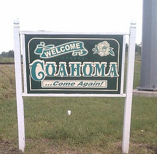
Coahoma is a town in Coahoma County, Mississippi, United States. Per the 2020 census, the population was 229.

<span class="mw-page-title-main">Yuba, Wisconsin</span> Village in Wisconsin, United States

Yuba is a village in Richland County, Wisconsin, United States. The population was 74 at the 2010 census. Yuba is 11 miles southwest of Hillsboro and 17 miles north of Richland Center. County Hwy C runs through the village.

<span class="mw-page-title-main">Duson, Louisiana</span> Town in Louisiana, United States

Duson is a town in Acadia and Lafayette parishes in the U.S. state of Louisiana. The town was named after Curley Duson, a sheriff of St. Landry Parish. At the 2010 U.S. census, the town had a population of 1,716; in 2020, at the population estimates program, its population was 1,761. The Lafayette Parish portion of Duson is part of the Lafayette metropolitan statistical area, while the Acadia Parish portion is part of the Crowley micropolitan statistical area. Duson also has a ghost town affiliated with it, a tiny neighborhood that was made but never finished. It is currently blocked off by the town's police.

<span class="mw-page-title-main">Tullos, Louisiana</span> Town in Louisiana, United States

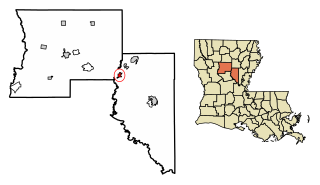
Tullos is a town in LaSalle and Winn parishes in the U.S. state of Louisiana, along Castor Creek. The population was 385 at the 2010 census.

Plainfield is a town in Waushara County, Wisconsin, United States. The population was 533 at the 2000 census. The village of Plainfield is surrounded by the town. The ghost town of West Plainfield is located in the town.

References

  1. "2020 U.S. Gazetteer Files". United States Census Bureau. Retrieved March 20, 2022.
  2. 1 2 "Geographic Identifiers: 2010 Demographic Profile Data (G001): Clayton town, Louisiana". U.S. Census Bureau, American Factfinder. Archived from the original on February 12, 2020. Retrieved August 20, 2014.
  3. "US Gazetteer files: 2010, 2000, and 1990". United States Census Bureau. February 12, 2011. Retrieved April 23, 2011.
  4. "Census of Population and Housing". Census.gov. Retrieved June 4, 2015.
  5. "Explore Census Data". data.census.gov. Retrieved December 29, 2021.
  6. "U.S. Census website". United States Census Bureau . Retrieved January 31, 2008.