Claytonville, Illinois

Last updated
Claytonville, Illinois
Claytonville, Illinois elevators.png
Grain elevators at Claytonville
Map of Illinois highlighting Iroquois County.svg
Iroquois County's location in Illinois
Location map of Iroquois County, Illinois.svg
Red pog.svg
Claytonville
Iroquois County's location in Illinois
Coordinates: 40°34′01″N87°49′23″W / 40.56694°N 87.82306°W / 40.56694; -87.82306 Coordinates: 40°34′01″N87°49′23″W / 40.56694°N 87.82306°W / 40.56694; -87.82306
Country Flag of the United States.svg  United States
State Flag of Illinois.svg  Illinois
County Iroquois County
Township Fountain Creek Township
Elevation
659 ft (201 m)
Time zone Central Standard Time
ZIP code
60926
Area code(s) 815
GNIS feature ID0406197 [1]

Claytonville is an unincorporated community in Iroquois County, Illinois, United States.

Iroquois County, Illinois County in the United States

Iroquois County is a county located in the northeast part of the U.S. state of Illinois. According to the 2010 census, it has a population of 29,718. It is the only county in the United States to be named Iroquois, after the American Indian people. The county seat is Watseka. The county is located along the border with Indiana.

Illinois State of the United States of America

Illinois is a state in the Midwestern and Great Lakes regions of the United States. It has the fifth largest gross domestic product (GDP), the sixth largest population, and the 25th largest land area of all U.S. states. Illinois has been noted as a microcosm of the entire United States. With Chicago in northeastern Illinois, small industrial cities and immense agricultural productivity in the north and center of the state, and natural resources such as coal, timber, and petroleum in the south, Illinois has a diverse economic base, and is a major transportation hub. Chicagoland, Chicago's metropolitan area, encompasses over 65% of the state's population. The Port of Chicago connects the state to international ports via two main routes: from the Great Lakes, via the Saint Lawrence Seaway, to the Atlantic Ocean and from the Great Lakes to the Mississippi River, via the Illinois Waterway to the Illinois River. The Mississippi River, the Ohio River, and the Wabash River form parts of the boundaries of Illinois. For decades, Chicago's O'Hare International Airport has been ranked as one of the world's busiest airports. Illinois has long had a reputation as a bellwether both in social and cultural terms and, through the 1980s, in politics.

Contents

Geography

Claytonville is located at 40°34′01″N87°49′20″W / 40.56694°N 87.82222°W / 40.56694; -87.82222 (40.566944, -87.822222), a little under four miles east of the town of Cissna Park and about two miles west of Goodwine. An east-west line of the Chicago and Eastern Illinois Railroad used to pass through the community but is now defunct.

Cissna Park, Illinois Village in Illinois, United States

Cissna Park is a village in Pigeon Grove Township, Iroquois County, Illinois, United States. The population was 846 at the 2010 census.

Goodwine, Illinois Unincorporated community in Illinois, United States

Goodwine is an unincorporated community in southern Iroquois County, Illinois, United States.

Chicago and Eastern Illinois Railroad defunct American Class I railway

The Chicago and Eastern Illinois Railroad was a Class I railroad that linked Chicago to southern Illinois, St. Louis, and Evansville. Founded in 1877, it grew aggressively and stayed relatively strong throughout the Great Depression and two World Wars before finally being purchased by the Missouri Pacific Railroad and the Louisville and Nashville Railroad (L&N). Missouri Pacific merged with the C&EI corporate entity in 1976, and was later acquired itself by the Union Pacific Railroad.

The small waterway Whiskey Creek runs along the north edge of town, flowing east to meet with Fountain Creek north of Goodwine.

Related Research Articles

Wadena, Indiana Unincorporated community in Indiana, United States

Wadena is an unincorporated community in Union Township, Benton County, Indiana. It is part of the Lafayette, Indiana Metropolitan Statistical Area.

Dunnington, Indiana Unincorporated community in Indiana, United States

Dunnington is a small unincorporated community in Parish Grove Township, Benton County, Indiana, United States, now virtually extinct. Named for Capt. James Dunn, it stands about one and a half miles west of its smaller sister town, Dunn. A post office was established at Dunnington in 1888, and was discontinued in 1903. In the early 20th century it supported a Catholic church and school, a general store, a Forresters lodge and about half a dozen residences. St. Mary's Catholic Church, established in the late 19th century, was renovated in the early 1950s and was home to St. Mary's Catholic School, which closed in the late 1960s.

Freeland Park, Indiana Unincorporated community in Indiana, United States

Freeland Park is an unincorporated community in Parish Grove Township, Benton County, Indiana. It is part of the Lafayette, Indiana Metropolitan Statistical Area.

Silver Creek Township, Stephenson County, Illinois Township in Illinois, United States

Silver Creek Township is a township in Stephenson County, Illinois. As of the 2010 census, its population was 696 and it contained 332 housing units.

Kankakee Township, Kankakee County, Illinois Township in Illinois, United States

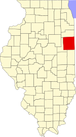
Kankakee Township is one of seventeen townships in Kankakee County, Illinois, USA. As of the 2010 census, its population was 27,558 and it contained 11,219 housing units. This township has the smallest area in the county, but is second largest in population.

Otto Township, Kankakee County, Illinois Township in Illinois, United States

Otto Township is one of seventeen townships in Kankakee County, Illinois, USA. As of the 2010 census, its population was 2,582 and it contained 937 housing units. It was formed from portions of Aroma and Limestone townships on December 11, 1855 as Carthage Township; its name was changed to Otto Township on March 11, 1857.

Pembroke Township, Kankakee County, Illinois Township in Illinois, United States

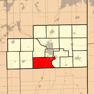
Pembroke Township is one of seventeen townships in Kankakee County, Illinois, USA. As of the 2010 census, its population was 2,140 and it contained 1,062 housing units. Pembroke Township was formed from parts of Momence township on February 17, 1877.

Yellowhead Township, Kankakee County, Illinois Township in Illinois, United States

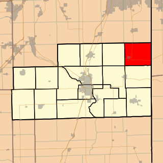
Yellowhead Township is one of seventeen townships in Kankakee County, Illinois, USA. As of the 2010 census, its population was 2,700 and it contained 1,065 housing units. Yellowhead Township derives its name from the Potawatomi warrior, Yellow Head, whose village was located at what is now Yellowhead Point.

Ash Grove Township, Iroquois County, Illinois Township in Illinois, United States

Ash Grove Township is one of twenty-six townships in Iroquois County, Illinois, USA. As of the 2010 census, its population was 731 and it contained 316 housing units.

Ashkum Township, Iroquois County, Illinois Township in Illinois, United States

Ashkum Township is one of twenty-six townships in Iroquois County, Illinois, USA. As of the 2010 census, its population was 1,542 and it contained 662 housing units. Ashkum Township formed from portions of Chebanse Township and Onarga Township in March, 1857.

Beaverville Township, Iroquois County, Illinois Township in Illinois, United States

Beaverville Township is one of twenty-six townships in Iroquois County, Illinois, USA. As of the 2010 census, its population was 609 and it contained 269 housing units. Beaverville Township formed from portions of Papineau Township and Beaver Township in September, 1921.

Belmont Township, Iroquois County, Illinois Township in Illinois, United States

Belmont Township is one of twenty-six townships in Iroquois County, Illinois, United States. As of the 2010 census, its population was 2,610 and it contained 1,188 housing units.

Douglas Township, Iroquois County, Illinois Township in Illinois, United States

Douglas Township is one of twenty-six townships in Iroquois County, Illinois, USA. As of the 2010 census, its population was 2,104 and it contained 923 housing units. Douglas Township was formed from a portion of Onarga Township in May 1858.

Fountain Creek Township, Iroquois County, Illinois Township in Illinois, United States

Fountain Creek Township is one of twenty-six townships in Iroquois County, Illinois, USA. As of the 2010 census, its population was 368 and it contained 145 housing units. Fountain Creek Township formed from a portion of Ash Grove Township on September 15, 1868.

Martinton Township, Iroquois County, Illinois Township in Illinois, United States

Martinton Township is one of twenty-six townships in Iroquois County, Illinois, USA. As of the 2010 census, its population was 943 and it contained 460 housing units. Buchanan Township formed from a portion of Papineau Township, then known as Wygant Township, in September 1857; its name was changed to Martinton Township on an unknown date.

Middleport Township, Iroquois County, Illinois Township in Illinois, United States

Middleport Township is one of twenty-six townships in Iroquois County, Illinois, USA. As of the 2010 census, its population was 4,375 and it contained 2,099 housing units. Middleport Township changed its name to Watseka Township in September 1863, but then changed back to Middleport Township on an unknown date.

Stockland Township, Iroquois County, Illinois Township in Illinois, United States

Stockland Township is one of twenty-six townships in Iroquois County, Illinois, USA. As of the 2010 census, its population was 243 and it contained 122 housing units. Stockland Township formed as Crab Apple Township in September 1864, but changed its name to Stockland Township on an unknown date.

Fountain Creek, Illinois Unincorporated community in Illinois, United States

Fountain Creek is an unincorporated community in Fountain Creek Township, Iroquois County, Illinois, United States. Fountain Creek is 5.5 miles (8.9 km) southeast of Cissna Park.

References

  1. "Claytonville". Geographic Names Information System . United States Geological Survey . Retrieved 2010-10-15.