
Chesterfield County is located just south of Richmond in the Commonwealth of Virginia. The county's borders are primarily defined by the James River to the north and the Appomattox River to the south. Its county seat is Chesterfield Court House.

Chester is a census-designated place (CDP) in Chesterfield County, Virginia, United States. Per the 2020 census, the population was 23,414.
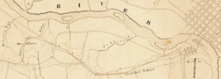
The Chesterfield Railroad was located in Chesterfield County, Virginia. It was a 13-mile (21-kilometer) long mule-and-gravity powered line that connected the Midlothian coal mines with wharves that were located at the head of navigation on the James River just below the Fall Line at Manchester. It began operating in 1831 as Virginia's first common carrier railroad.
Midlothian is an unincorporated area in Chesterfield County, Virginia, U.S. Settled as a coal town, Midlothian village experienced suburbanization effects and is now part of the western suburbs of Richmond, Virginia south of the James River in the Greater Richmond Region. Because of its unincorporated status, Midlothian has no formal government, and the name is used to represent the original small Village of Midlothian and a vast expanse of Chesterfield County in the northwest portion of Southside Richmond served by the Midlothian post office.
The Southside Railroad was formed in Virginia in 1846. Construction was begun in 1849 and completed in 1854. The 5 ft gauge railroad connected City Point, a port on the James River with the farm country south and west of Petersburg, Virginia, to Lynchburg, Virginia, a distance of about 132 miles (212 km).

In 1836, the Virginia House of Delegates approved a charter for the City Point Railroad. City Point, Virginia, was just ten years old. The Lower Appomattox Company ran boats of cargo from Petersburg, Virginia, to the large port at City Point. The company knew that the port needed a rail road to be competitive in the 1830s even though this would only be the second rail road in Virginia. Large ships that were too large for Port Walthall or Petersburg had to load and unload at City Point. Goods for export arrived in Petersburg from farms and plantations by way of the Upper Appomattox Canal Navigation System. The Richmond and Petersburg Railroad bringing coal and goods to port was also chartered in 1836. Coal arriving by boat from the Clover Hill Pits in 1837 and goods would soon be taken on the Clover Hill Railroad to connect with the Richmond and Petersburg Railroad to export from the area ports.

The Southside of Richmond is an area of the Metropolitan Statistical Area surrounding Richmond, Virginia. It generally includes all portions of the City of Richmond that lie south of the James River, and includes all of the former city of Manchester. Depending on context, the term "Southside of Richmond" can include some northern areas of adjacent Chesterfield County, Virginia in the Richmond-Petersburg region. With minor exceptions near Bon Air, VA, the Chippenham Parkway forms the border between Chesterfield County and the City of Richmond portions of Southside, with some news agencies using the term "South Richmond" to refer to the locations in Southside located in the city proper.
Winterpock is an unincorporated community in western Chesterfield County, Virginia, United States. Winterpock does not have its own post office.

Port Walthall was a town located on the north bank of the Appomattox River in Chesterfield County, Virginia, United States, a few miles upriver from its confluence with the James River at City Point.
The Richmond and Petersburg Railroad moved passengers and goods between Richmond and Petersburg from 1838 to 1898. It survived the American Civil War and eventually merged into the Atlantic Coast Line Railroad in 1900.

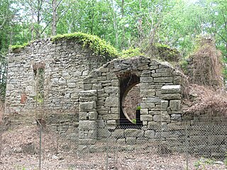
Black Heath was a house and coal mine located along the Old Buckingham Road in the present Midlothian area of Chesterfield County, Virginia. The Black Heath coal mining enterprises were operated by the Heth family between 1785 and 1844, when the mine closed following a fatal explosion.

Eppington is a historic plantation house located near Winterpock, Chesterfield County, Virginia. It was built about 1768, and consists of a three-bay, 2+1⁄2-story, central block with hipped roof, dormers, modillion cornice, and flanking one-story wings in the Georgian style. It has a later two-story rear ell. It features two tall exterior end chimneys which rise from the roof of the wings. It was listed on the National Register of Historic Places in 1969.

In 1886, Randolph Harrison, of the Virginia department of Agriculture, cited Cumberland Mining Company, stating that the United States had purchased stock in the Brighthope Railway. He continued by citing their assertion that extending the railway into Cumberland would increase the value of farms there because they could sell consumer agricultural products such as fruit, dairy and vegetables to all markets of Virginia. The Brighthope Railway was founded in 1877 by the creditors of the Clover Hill Railroad who bought that railroad when the Clover Hill Railroad went bankrupt. The Brighthope Railway continued in the role of the Clover Hill Railroad, hauling coal from the Clover Hill Pits at Winterpock, Virginia. In addition to coal, the Bright Hope Railway transported timber and agricultural products and had passenger service. The Bright Hope Railway was narrowed from standard gauge to narrow gauge and rerouted in 1881. In 1886, much of the southern rails were changed to standard gauge. The Brighthope Railway was not changed back.

In 1886, Randolph Harrison, of the Virginia department of Agriculture, cited Cumberland Mining Company, stating that businessmen would soon open a hotel at Lithia Springs, Farmville, VA for people seeking the healing waters. The Brighthope railway would be extended to bring them there. But instead, the Farmville and Powhatan Railroad Company built the narrow gauge rails through Cumberland County and the Farmville and Powhatan Railroad Company bought the Brighthope Railway, so the Farmville and Powhatan Railroad made the connection. In 1890, Beach Station was built with a railroad depot, some railroad shanties, a general store and an owner's house, the George Perdue House as a stop on the line.
The Clover Hill Pits are a number of coal shafts and mines that operated in the Southside area of Richmond, Virginia, from 1837 until around 1883.

The Swift Creek Rail Bridge was a granite and iron truss bridge over Swift Creek in Virginia. The Tidewater and Western Railroad included a bridge over Swift Creek that had been built by an earlier railroad company, the Clover Hill Railroad. The bridge was used during the whole time the four railroad companies operated rails over the bridge. The metal on the bridge was sold as part of foreclosure of the final company in 1917.

The Farmville and Powhatan Railroad went bankrupt in 1905 and became the Tidewater and Western Railroad. The line survived until 1917 when it was pulled up and sent to France for the World War I effort. The Tidewater and Western Railroad carried freight and passengers along a route from Farmville, Virginia to Bermuda Hundred. The Tidewater and Western Railroad continued to have Western Union Telegraphs run along the rails. These connected to telegraphs on the Atlantic Coast Line along the East Coast of the US and to Europe.
The Upper Appomattox Canal Navigation system allowed farmers who took their wheat and corn to mills on the Appomattox River, as far way as Farmville, Virginia, to ship the flour all the way to Petersburg from 1745 to 1891. The system included a navigation, modifications on the Appomattox River, a Canal around the falls Petersburg, and a turning basin in Petersburg to turn their narrow long boats around, unload the farm products from upstream and load up with manufactured goods from Petersburg. In Petersburg, workers could put goods on ships bound for the Chesapeake Bay and load goods from far away for Farmville and plantations upstream. Canal boats would return up river with manufactured goods. People who could afford it, rode in boats on the canal as the fastest and most comfortable ride. The river was used for transportation and shipping goods for over 100 years.
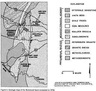
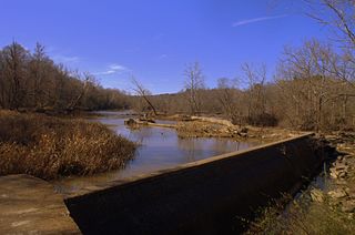
The Richmond Basin was one of the Eastern North America Rift Basins. It lies over Swift Creek Reservoir from Interstate 64 to the Appomattox River.
The Richmond Coalfield was the first coalfield to be mined commercially in the United States of America. The coalfield is located several miles west of the city of Richmond, Virginia. Its bituminous coal seams are a part of the Richmond Basin, dating to the Late Triassic.


