
The Leonard P. ZakimBunker Hill Memorial Bridge is a cable-stayed bridge completed in 2003 across the Charles River in Boston, Massachusetts. It is a replacement for the Charlestown High Bridge, an older truss bridge constructed in the 1950s.

The Dartford–Thurrock River Crossing, commonly known as the Dartford Crossing and until 1991 the Dartford Tunnel, is a major road crossing of the River Thames in England, carrying the A282 road between Dartford in Kent in the south and Thurrock in Essex in the north.

The Blackwall Tunnel is a pair of road tunnels underneath the River Thames in east London, England, linking the London Borough of Tower Hamlets with the Royal Borough of Greenwich, and part of the A102 road. The northern portal lies just south of the East India Dock Road (A13) in Blackwall; the southern entrances are just south of The O2 on the Greenwich Peninsula. The road is managed by Transport for London (TfL).
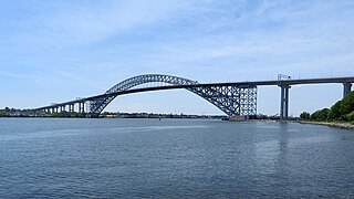
The Bayonne Bridge is an arch bridge that spans the Kill Van Kull between Staten Island, New York and Bayonne, New Jersey. It carries New York State Route 440 and New Jersey Route 440, with the two roads connecting at the state border at the river’s center. It has the sixth-longest steel arch mainspan in the world, and this span was the longest in the world at the time of its completion. The bridge is also one of four connecting New Jersey with Staten Island; the other two roadway bridges are the Goethals Bridge in Elizabeth and Outerbridge Crossing in Perth Amboy, and the rail-only span is the Arthur Kill Vertical Lift Bridge, all of which cross the Arthur Kill.
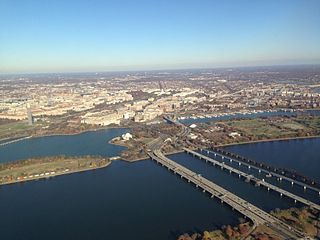
The 14th Street bridges refers to the three bridges near each other that cross the Potomac River, connecting Arlington, Virginia and Washington, D.C. Sometimes the two nearby rail bridges are included as part of the 14th Street bridge complex. A major gateway for automotive, bicycle and rail traffic, the bridge complex is named for 14th Street, which feeds automotive traffic into it on the D.C. end.
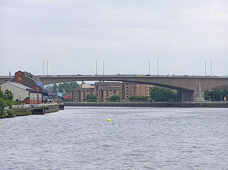
The Kingston Bridge is a balanced cantilever dual-span ten lane road bridge made of triple-cell segmented prestressed concrete box girders crossing the River Clyde in Glasgow, Scotland.

The James River Bridge (JRB) is a four-lane divided highway lift bridge across the James River in the Commonwealth of Virginia. Owned and operated by the Virginia Department of Transportation, it carries U.S. Route 17 (US 17), US 258, and State Route 32 across the river near its mouth at Hampton Roads. The bridge connects Newport News on the Virginia Peninsula with Isle of Wight County in the South Hampton Roads region, and is the easternmost such crossing without a tunnel component.

Interstate 395 (I-395) in Virginia and Washington, D.C., is a 13.79-mile-long (22.19 km) spur route of I-95 that begins at an interchange with I-95 in Springfield and ends at an interchange with US Route 50 (US 50) in Northwest Washington, D.C. It passes underneath the National Mall near the US Capitol and ends at a junction with US 50 at New York Avenue, roughly one mile (1.6 km) north of the 3rd Street Tunnel. Despite its proximity to I-395 in Maryland, the route is unrelated and unconnected.

The Erskine Bridge is a multi span cable-stayed box girder bridge spanning the River Clyde in west central Scotland. The bridge connects West Dunbartonshire with Renfrewshire and can be used by all types of motor vehicles, cyclists and pedestrians. As well as crossing the Clyde, the bridge also crosses the Forth and Clyde Canal and the North Clyde railway line. A small part of Kilpatrick railway station is situated underneath the bridge at the north side. The bridge is part of the A898 road. On completion the bridge replaced the Erskine to Old Kilpatrick ferry service.

The George Massey Tunnel is a highway traffic tunnel in the Metro Vancouver region of southwestern British Columbia. It is located approximately 20 km (12.4 mi) south of the city centre of Vancouver, British Columbia, and approximately 30 km (18.6 mi) north of the Canada–United States border at Blaine, Washington.

The Willis Avenue Bridge is a swing bridge that carries road traffic northbound over the Harlem River between the New York City boroughs of Manhattan and the Bronx, United States. It connects First Avenue in Manhattan with Willis Avenue in the Bronx. The New York City Department of Transportation is responsible for maintaining and operating the bridge.
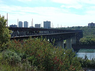
The High Level Bridge is a bridge that spans the North Saskatchewan River in Edmonton, Alberta, Canada.

The Birmingham Bridge is a bowstring arch bridge that is located in Pittsburgh, Pennsylvania and spans the Monongahela River.

The Ohio River Bridges Project was a transportation project in the Louisville metropolitan area involving the reconstruction of the Kennedy Interchange, the completion of two new Ohio River bridges, and the reconstruction of ramps on Interstate 65 between Muhammad Ali Boulevard and downtown Louisville.

The Nowra Bridge is a road bridge that carries the Princes Highway over the Shoalhaven River, at Nowra, New South Wales, Australia. The bridge joins the main area of Nowra to North Nowra and Bomaderry.

The Carl E. Stotz Memorial Little League Bridge, formerly known as the Market Street Bridge, carries approximately 27,700 vehicles a day on U.S. Route 15 over the West Branch Susquehanna River between Williamsport and South Williamsport in Lycoming County, Pennsylvania, in the United States. It is the seventh bridge on the site and was built at a cost of over $60,000,000.

The U.S. 40 and 59 Bridges are twin multi-beam girder bridges over the Kansas River at Lawrence, Kansas. The west bridge carries two lanes of southbound traffic, connecting to Vermont Street, while the east bridge carries two lanes of northbound traffic from Massachusetts Street. Both bridges converge on the north end to become North 2nd Street. The east bridge is also the third bridge to be built at this location.

The Walterdale Bridge is a through arch bridge across the North Saskatchewan River in Edmonton, Alberta, Canada. It replaced the previous Walterdale Bridge in 2017. The new bridge has three lanes for northbound vehicular traffic and improved pedestrian and cyclist crossings.
The Temse Bridge crosses the Scheldt at Temse, a small town approximately 25 km southwest of Antwerp. Between 1955 and 2009 the 365 m (1,197.5 ft) bridge was the longest in Belgium. The old bridge lost that distinction to the New Schelde Bridge which runs parallel to it, and has a length of 374 m (1,227.0 ft).

The Samuel De Champlain Bridge, colloquially known as the Champlain Bridge, is a cable-stayed bridge design by architect Poul Ove Jensen and built to replace the original Champlain Bridge over the Saint Lawrence River in Quebec, between Nuns' Island in the borough of Verdun in Montreal and the suburban city of Brossard on the South Shore. A second, connected bridge links Nuns' Island to the main Island of Montreal. The bridge is the busiest bridge in the country with more cars flowing into it than any other bridge.

