
Cape Cod is an arm-shaped peninsula extending into the Atlantic Ocean from the southeastern corner of Massachusetts, in the northeastern United States. Its historic, maritime character and ample beaches attract heavy tourism during the summer months. The name Cape Cod, coined in 1602 by Bartholomew Gosnold, is the ninth oldest English place-name in the U.S.
The Cape Cod National Seashore (CCNS) encompasses 43,607 acres on Cape Cod, in Massachusetts. CCNS was created on August 7, 1961, by President John F. Kennedy, when he signed a bill enacting the legislation he first co-sponsored as a Senator a few years prior. It includes ponds, woods and beachfront of the Atlantic coastal pine barrens ecoregion. The CCNS includes nearly 40 miles (64 km) of seashore along the Atlantic-facing eastern shore of Cape Cod, in the towns of Provincetown, Truro, Wellfleet, Eastham, Orleans and Chatham. It is administered by the National Park Service.

Provincetown is a New England town located at the extreme tip of Cape Cod in Barnstable County, Massachusetts, in the United States. A small coastal resort town with a year-round population of 3,664 as of the 2020 United States Census, Provincetown has a summer population as high as 60,000. Often called "P-town" or "Ptown", the locale is known for its beaches, harbor, artists, tourist industry, and as a popular vacation destination for the LGBT+ community.

Truro is a town in Barnstable County, Massachusetts, United States, comprising two villages: Truro and North Truro. Located slightly more than 100 miles (160 km) by road from Boston, it is a summer vacation community just south of the northern tip of Cape Cod, in an area known as the "Outer Cape". English colonists named it after Truro in Cornwall, United Kingdom.

Provincetown Harbor is a large natural harbor located in the town of Provincetown, Massachusetts. The harbor is mostly 30 to 90 feet deep and stretches roughly 1 mile (1.6 km) from northwest to southeast and 2 miles (3.2 km) from northeast to southwest – one large, deep basin with no dredged channel necessary for boats to enter and exit.
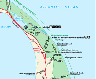
North Truro is a village in the town of Truro, Massachusetts, United States. Due to its proximity to urbanized Provincetown, it is somewhat more densely developed than the rest of the town, with houses and small resort facilities lining the two main thoroughfares, U.S. Route 6 and MA Route 6A. It is home to Truro Vineyards, one of two operating wineries on Cape Cod. North Truro is located at 42°03′35″N70°08′31″W.

Nixes Mate, also known as Nixes Island, Nix's Mate and Nick's Mate, is one of the smaller islands in the Boston Harbor Islands National Recreation Area. Located in Boston Harbor's outer limits near the convergence of three major channels, the island lies about 5 nautical miles from downtown Boston and about 0.6 nautical miles east of Long Island Head Light. The island covers and uncovers with the tide and is not open to the public. It is described in the Light List as "Nixes Mate: black, white band midway of height, octagonal pyramid on square granite base", Light List number 1-11450.
A Coast Guard Air Station provides aviation support for the United States Coast Guard. The Coast Guard operates approximately 210 aircraft from 24 Coast Guard Air Stations in the United States. Fixed-wing aircraft, such as the HC-130 Hercules, are built for long range missions and operate from air stations. The MH-65D Dolphin and Sikorsky HH-60 Jayhawk helicopters also operate from Air Stations, Air Facilities and flight deck equipped cutters.

The Pilgrim Monument in Provincetown, Massachusetts, was built between 1907 and 1910 to commemorate the first landfall of the Pilgrims in 1620 and the signing of the Mayflower Compact in Provincetown Harbor. This 252-foot-7+1⁄2-inch-tall (77.0 m) campanile is the tallest all-granite structure in the United States and is part of the Provincetown Historic District.

Race Point Light is a historic lighthouse on Cape Cod, in Provincetown, Massachusetts; it is on the National Register of Historic Places. The original tower, first illuminated in 1816, was replaced in 1876 with the current 45-foot tall iron-plated tower and a new keeper's dwelling. The American Lighthouse Foundation operates the property and rents out two buildings for overnight stays. The actual light is maintained by the Coast Guard. The site is reached by walking about 45 minutes over sand; with a National Park Service Oversand Permit, a four-wheel-drive vehicle can be used.

Long Point Light Station is a historic lighthouse at the northeast tip of Long Point in Provincetown, Massachusetts. As a navigational aid, it marks the southwest edge of the entrance to Provincetown Harbor. The United States Coast Guard Light List describes it simply as a "white square tower". The light it casts is green, occulting every 4 seconds, and, at a focal height of 35.5 feet (10.8 m) above mean sea level, has a visible range of 8 nautical miles. When the weather affords low-visibility, one can hear the station's fog horn – sounding a single blast for two seconds, and repeating every 15 seconds – as it seems to call out for its nearly-identical closest neighbor, the Wood End Light.

Wood End Light Lookout Station is a historic lighthouse, located at the southwest end of Long Point in Provincetown, Massachusetts. It is located at Wood End, near the southernmost extent of the Provincetown Spit, and acts as a navigational aid to vessels on their approach to Provincetown Harbor. The Long Point Light Station, further down the peninsula at the tip of Long Point is an identical design and completed in 1875, three years after Wood End Light.
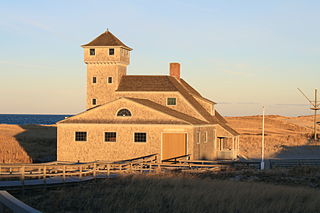
The Old Harbor U.S. Life Saving Station is a historic maritime rescue station and museum, located at Race Point Beach in Provincetown, Massachusetts. Built in 1897, it was originally located at Nauset Beach near the entrance to Chatham Harbor in Chatham, Massachusetts. It was used by the United States Life-Saving Service (USLSS), and then by its successor, the United States Coast Guard (USCG), as the Old Harbor Coast Guard Station. The station was decommissioned in 1944, abandoned and sold as surplus in 1947, and was used as a private residence for the next twenty-six years.
Isaac Mayo was a junior surfman in the United States Life-Saving Service, one of the agencies later amalgamated into the United States Coast Guard in 1915. On April 4, 1879, he led multiple and eventually successful efforts to rescue seamen stranded in an offshore wreck at the height of a violent storm.

The Dune Shacks of Peaked Hill Bars Historic District includes dune shacks that were home to American artists and writers from the 1920s to present day. The historic district, located in the Outer Cape towns of Provincetown and Truro, comprises 1,950 acres of the Cape Cod National Seashore. It was listed on the National Register of Historic Places in 2012. The name is derived from a Life-Saving Station known as Peaked Hill Bars that was established in 1882 on the lower cape.
The USCGC Harriet Lane (WSC-141) was a 125-foot patrol boat, commonly known as a "buck-and-a-quarter", 1926–1946.
USCGC Cape Horn was a 95-foot (29 m) type "C" Cape-class cutter constructed at the Coast Guard Yard at Curtis Bay, Maryland, in 1958 for use as a law enforcement and search and rescue patrol boat.


