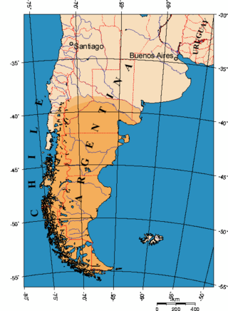
Chile, officially the Republic of Chile, is a country in western South America. It is the southernmost country in the world and the closest to Antarctica, stretching along a narrow strip of land between the Andes Mountains and the Pacific Ocean. Chile had a population of 17.5 million as of the latest census in 2017 and has a territorial area of 756,102 square kilometers (291,933 sq mi), sharing borders with Peru to the north, Bolivia to the northeast, Argentina to the east, and the Drake Passage to the south. The country also controls several Pacific islands, including Juan Fernández, Isla Salas y Gómez, Desventuradas, and Easter Island, and claims about 1,250,000 square kilometers (480,000 sq mi) of Antarctica as the Chilean Antarctic Territory. The capital and largest city of Chile is Santiago, and the national language is Spanish.
Patagonia is a geographical region that encompasses the southern end of South America, governed by Argentina and Chile. The region comprises the southern section of the Andes Mountains with lakes, fjords, temperate rainforests, and glaciers in the west and deserts, tablelands, and steppes to the east. Patagonia is bounded by the Pacific Ocean on the west, the Atlantic Ocean to the east, and many bodies of water that connect them, such as the Strait of Magellan, the Beagle Channel, and the Drake Passage to the south.
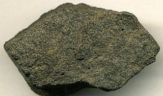
Phosphorite, phosphate rock or rock phosphate is a non-detrital sedimentary rock that contains high amounts of phosphate minerals. The phosphate content of phosphorite (or grade of phosphate rock) varies greatly, from 4% to 20% phosphorus pentoxide (P2O5). Marketed phosphate rock is enriched ("beneficiated") to at least 28%, often more than 30% P2O5. This occurs through washing, screening, de-liming, magnetic separation or flotation. By comparison, the average phosphorus content of sedimentary rocks is less than 0.2%.

The Sandhills or Carolina Sandhills is a 10-35 mi wide physiographic region within the U.S. Atlantic Coastal Plain province, along the updip (inland) margin of this province in the states of North Carolina, South Carolina, and Georgia. The extent of the Carolina Sandhills is shown in maps of the ecoregions of North Carolina, South Carolina, and Georgia.

In geology, a terrace is a step-like landform. A terrace consists of a flat or gently sloping geomorphic surface, called a tread, that is typically bounded on one side by a steeper ascending slope, which is called a "riser" or "scarp". The tread and the steeper descending slope together constitute the terrace. Terraces can also consist of a tread bounded on all sides by a descending riser or scarp. A narrow terrace is often called a bench.

Chañaral is a small coastal city and commune in the Atacama Region, Chile and capital of the Chañaral Province. Despite it being coastal, it is not a seaside resort, partly because the ocean is contaminated by the copper mining industry. Situated a short distance to the north is the Pan de Azúcar National Park.
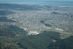
The Central Valley, Intermediate Depression, or Longitudinal Valley is the depression between the Chilean Coastal Range and the Andes Mountains. The Chilean Central Valley extends from the border with Peru to Puerto Montt in southern Chile, with a notable interruption at Norte Chico. South of Puerto Montt the valley has a continuation as a series of marine basins up to the isthmus of Ofqui. Some of Chile's most populous cities lie within the valley including Santiago, Temuco, Rancagua, Talca and Chillán.

The protected areas of Chile are areas that have natural beauty or significant historical value protected by the government of Chile. These protected areas cover over 140,000 km2 (54,054 sq mi), which is 19% of the territory of Chile. The National System of Protected Wild Areas is regulated by law #18,362 passed in 1984, and administered by the National Forest Corporation (CONAF).

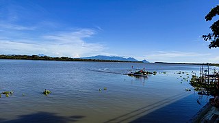
Budi Lake from the Mapudungun word Füzi which means salt, is a tidal brackish water lake located near the coast of La Araucanía Region, southern Chile. The lake is part of the boundaries between Saavedra and Teodoro Schmidt commune.

The Tendaguru Formation, or Tendaguru Beds are a highly fossiliferous formation and Lagerstätte located in the Lindi Region of southeastern Tanzania. The formation represents the oldest sedimentary unit of the Mandawa Basin, overlying Neoproterozoic basement, separating by a long hiatus and unconformity. The formation reaches a total sedimentary thickness of more than 110 metres (360 ft). The formation ranges in age from the late Middle Jurassic to the Early Cretaceous, Oxfordian to Hauterivian stages, with the base of the formation possibly extending into the Callovian.

The Chilean Marine Corps is an entity of the Chilean Navy special forces which specializes in amphibious assaults.
The Colombian Naval Infantry, also referred to as Colombian Marines, is the marine force of the Colombian National Armada. The 53,123-member Colombian Marine Infantry is organized into a single division with four brigades, each with several battalions plus numerous small security units.
The Bicol River is the eighth largest river in the Philippines in terms of drainage basin size with an estimated catchment area of 3,770 square kilometres (1,460 sq mi). The river drains a large part of southwestern Bicol Peninsula of the island of Luzon and passes through Camarines Sur province.

The Straight Cliffs Formation is a stratigraphic unit in the Kaiparowits Plateau of south central Utah. It is Late Cretaceous in age and contains fluvial, paralic, and marginal marine (shoreline) siliciclastic strata. It is well exposed around the margin of the Kaiparowits Plateau in the Grand Staircase – Escalante National Monument in south central Utah. The formation is named after the Straight Cliffs, a long band of cliffs creating the topographic feature Fiftymile Mountain.
The Chacarilla Formation is an Oxfordian to Early Cretaceous geologic formation of the Tarapacá Basin in northern Chile, close to the border with Bolivia. The marine and fluvial formation preserves several dinosaur trackways and has been declared a Natural Sanctuary in 2004.

The Hoya of Guadix is a natural plain in the northern part of the province of Granada, Andalusia, Spain. It covers some 500 square kilometres (190 sq mi), and is formed by the basins of the rivers Fardes and Guadix. It is surrounded by the heights of the Sierra Nevada to the south, the Sierra de Baza to the east, the Sierra Mágina to the north and the Sierra Harana to the west. It is separated by the Cerro Jabalcón from the Hoya of Baza which, like the Hoya of Guadix, is one of the series of valleys forming the Surco Intrabético.
Navidad Formation is a marine Neogene sedimentary formation located in Central Chile. The formation is known for its diverse and abundant fossil record and is considered the reference unit for the marine Neogene in Chile. Originally described by Charles Darwin in 1846 the formation has attracted the attention of numerous prominent geologists and paleontologists since then. As a key formation Navidad has been subject to a series of differing interpretations and scientific disputes over time.

Inland dunes are eolian sand dunes that are found inland, away from coastal regions.

La Negra Formation is a geologic formation of Jurassic age, composed chiefly of volcanic and volcaniclastic rocks, located in the Coast Range of northern Chile. The formation originated in marine and continental (terrestrial) conditions, and bears evidence of submarine volcanism as well as large explosive eruptions. The volcanism of La Negra Formation is thought to have lasted for about five million years.
Guyana belongs to the Guiana Shield, a massif extending north of the Amazon, between the Andes Mountains and the Atlantic, made up of Precambrian rocks dated to between 2.7 and 3.5 billion years ago. The shield consists of several geological units: the southern peneplain, the Inini synclinorium, the central granite massifs and the northern synclinorium. The southern peneplain consists of a set of granito-gneiss consisting of metagabbros, metagranodiorites and metagranites dating from 2075 ± 7 Ma from a magma of metamorphosed mantle origin. To the north, the southern peneplain straddles the Inini synclinorium, mainly composed of the Paramaca series, which corresponds to a series of micaschists, aluminous paragneisses and black quartzites whose total thickness is about 1 km. The central granite massifs consist of granite plutons, granodiorites and quartz diorites dating from 2.05 to 2.15 billion years ago. The north of French Guiana corresponds to a synclinorium composed of the Paramaca series on which sandstone and fluviatile conglomerates lie unconformably. Shield rocks in Guyana are all dated between 1.6 and 2.5 billion years ago.