
Vacaville is a city located in Solano County, California. Sitting about 35 miles (56 km) from Sacramento and 55 miles (89 km) from San Francisco, it is on the edge of the Sacramento Valley in Northern California. The city was founded in 1851 and is named after Juan Manuel Vaca.

Alameda County is a county located in the U.S. state of California. As of the 2020 census, the population was 1,682,353, making it the 7th-most populous county in the state and 21st most populous nationally. The county seat is Oakland. Alameda County is in the San Francisco Bay Area, occupying much of the East Bay region.

Contra Costa County is a county located in the U.S. state of California, in the East Bay of the San Francisco Bay Area. As of the 2020 United States Census, the population was 1,165,927. The county seat is Martinez. It occupies the northern portion of the East Bay region of the San Francisco Bay Area and is primarily suburban. The county's name refers to its position on the other side of the bay from San Francisco. Contra Costa County is included in the San Francisco–Oakland–Berkeley, CA Metropolitan Statistical Area.
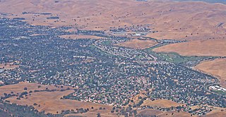
Alamo is an unincorporated community and census-designated place (CDP) in Contra Costa County, California, in the United States. It is a suburb located in the San Francisco Bay Area's East Bay region, approximately 28 miles (45 km) east of San Francisco. Alamo is equidistant from the city of Walnut Creek and the incorporated town of Danville. As of the 2020 census, the population was 15,314.
Clayton is a city in Contra Costa County, California, United States. The population was 11,585 as of the 2020 census.

Concord is the most populous city in Contra Costa County, California, United States. According to an estimate completed by the United States Census Bureau, the city had a population of 129,295 in 2019, making it the eighth largest city in the San Francisco Bay Area. Founded in 1869 as Todos Santos by don Salvio Pacheco II, a noted Californio ranchero, the name was later changed to Concord. The city is a major regional suburban East Bay center within the San Francisco Bay Area, and is 29 miles east of San Francisco.
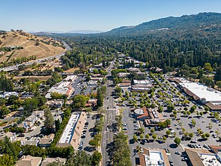
The Town of Danville is located in the San Ramon Valley in Contra Costa County, California, United States. It is one of the incorporated municipalities in California that use "town" in their names instead of "city". The population was 43,582 at the 2020 census. Since 2018, for five years in a row, Danville was named "the safest town in California".

Martinez is a city and the county seat of Contra Costa County, California, United States, in the East Bay region of the San Francisco Bay Area. Located on the southern shore of the Carquinez Strait, the city's population was 37,287 at the 2020 census. The city is named after Californio ranchero Ygnacio Martínez, having been founded on his Rancho El Pinole. Martinez is known for its historic center and its waterfront.

Pleasant Hill is a city in Contra Costa County, California, United States, in the East Bay of the San Francisco Bay Area. The population was 34,613 at the 2020 census. It was incorporated in 1961. Pleasant Hill is the home of College Park High School, Diablo Valley College, the Pleasant Hill Library of the Contra Costa County Library system, and the Pleasant Hill Recreation & Park District.

Walnut Creek is a city in Contra Costa County, California, United States, located in the East Bay region of the San Francisco Bay Area, about 16 miles east of the city of Oakland. Walnut Creek has a total population of 70,127 per the 2020 census, is located at the junction of the highways from Sacramento and San Jose (I-680) and San Francisco/Oakland (SR-24), and is accessible by BART. The city shares its borders with Clayton, Lafayette, Alamo, Pleasant Hill, and Concord.

Ygnacio Valley High School (YVHS) is a public secondary school located in Concord, California, United States. It draws students from Concord as well as from the neighboring communities of Walnut Creek and Pleasant Hill. The school opened in 1962, and its first senior class graduated in 1964. Originally conceived as a temporary facility, the school currently carries an enrollment of over 1,500 total students for grades 9 through 12. When the nearby Northgate High School opened in 1974, YVHS lost approximately half its student body at the time. The school is part of the Mount Diablo Unified School District.

The Diablo Range is a mountain range in the California Coast Ranges subdivision of the Pacific Coast Ranges in northern California, United States. It stretches from the eastern San Francisco Bay Area at its northern end to the Salinas Valley area at its southern end.

Rockridge is a residential neighborhood and commercial district in Oakland, California. Rockridge is generally defined as the area east of Telegraph Avenue, south of the Berkeley city limits, west of the Oakland hills and north of the intersection of Pleasant Valley Avenue/51st Street and Broadway. Rockridge was listed by Money Magazine in 2002 as one of the "best places to live".
Clayton Valley Charter High School (CVCHS) is a comprehensive charter high school located in Concord, California, United States, just under two miles from Clayton. Most of the school's students live in Clayton and the nearby Concord neighborhoods.
Mount Diablo Unified School District (MDUSD) is a public school district in Contra Costa County, California. It currently operates 29 elementary schools, 9 middle schools, and 5 high schools, with 7 alternative school programs and an adult education program. MDUSD is one of the largest school districts in the state of California, with over 56 school sites and a budget of approximately $270,000,000. The district has over 36,000 K-12 students, over 20,000 adult education students, and over 3,500 employees, including over 2,000 certificated educators. The district covers 150 square miles (390 km2), including the cities of Concord and Clayton; as well as most of Pleasant Hill and portions of Walnut Creek, Pittsburg, Lafayette, and Martinez; and unincorporated areas, including Pacheco, Clyde, and Bay Point.
The Contra Costa Community College District is a community college district that encompasses three community colleges in Contra Costa County, California - Contra Costa College, Diablo Valley College and Los Medanos College. The headquarters is in the George R. Gordon Education Center in Martinez, California.
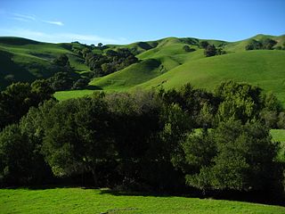
Briones Regional Park is a 6,117-acre (24.75 km2) regional park in the East Bay Regional Park District (EBRPD) system, located in the Briones Hills of central Contra Costa County of the San Francisco Bay Area in California.

The Briones Hills form a low mountain range in western Contra Costa County, in the East Bay region of the San Francisco Bay Area, California, United States.

Ukiah High School is the oldest public high school in Ukiah, California, the seat of Mendocino County. Established in 1893, it is the largest school by enrollment and only four-year comprehensive high school in the Ukiah Unified School District. It serves all students in the ninth through twelfth grades from the incorporated city of Ukiah plus the four smaller, adjacent communities of Calpella, Hopland, Redwood Valley and Talmage and other rural residents of southeastern Mendocino County. The district's boundaries encompass a total area of 495 square miles (1,280 km2) with a population of approximately 40,000.

Travis Santo Raciti is an American football defensive end who is currently a free agent. He played college football at San Jose State and was signed by the Philadelphia Eagles as an undrafted free agent in 2015.

