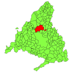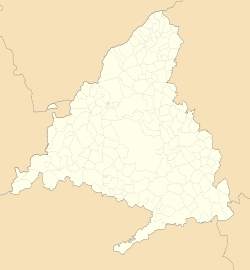
The Community of Madrid is one of the seventeen autonomous communities of Spain. It is located in the centre of the Iberian Peninsula, and of the Central Plateau . Its capital and largest municipality is the City of Madrid, which is also the capital of the country. The Community of Madrid is bounded to the south and east by Castilla–La Mancha and to the north and west by Castile and León. It was formally created in 1983, based on the limits of the province of Madrid, which was until then conventionally included in the historical region of New Castile.

Castilla–La Mancha, or Castile La Mancha, is an autonomous community of Spain. Comprising the provinces of Albacete, Ciudad Real, Cuenca, Guadalajara and Toledo, it was created in 1982. The government headquarters are in Toledo, and its largest city is in Albacete.

Ciudad Real is a municipality of Spain located in the autonomous community of Castile–La Mancha, capital of the province of Ciudad Real. It is the 5th most populated municipality in the region.

Tres Cantos is a municipality of Spain located in Community of Madrid.
Soto del Real, whose former name was Chozas de la Sierra, is a town and municipality in the northern area of the autonomous Community of Madrid which had 8,294 inhabitants in 2009.

San Sebastián de los Reyes is a municipality in the Community of Madrid, Spain. Founded in 1492, it is located 20 km north of Madrid.

Collado Villalba is a municipality of the Community of Madrid, in central Spain. It is located 40.3 kilometres north-west of the city of Madrid, at an altitude of 917 meters above sea level. It has a population of 63,679 (2019), with a population density of about 2,400 per km². Collado Villalba has a hot summer Mediterranean climate.

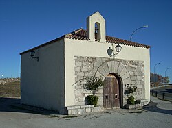
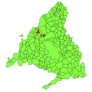
San Agustín del Guadalix is a Spanish town located north of the Comunidad de Madrid, near to Sierra de Guadarrama.

Manzanares el Real is a 8,936 inhabitant town in the northern area of the autonomous Community of Madrid. It is located at the foot of The Pedriza, a part of the Sierra de Guadarrama, and next to the embalse de Santillana.

The designation artede (la) repoblación was first proposed by José Camón Aznar in 1949 to replace the term Mozarabic as applied to certain works of architecture from the Christian kingdoms of northern Spain between the end of the 9th and beginning of the 11th centuries. Camón argued that these buildings were related stylistically to the architecture of Asturias and owed little to Andalusian styles. Moreover, since they were built by Christians living under Christian rule, neither were they Mozarabic.
Spain has many coats of arms: the nation has one, the reigning monarch and the heir presumptive each have one, and there are others for the institutions of state and for Spanish regions and towns.

Algete is a town and municipality in central Spain. It lies in the comarca de Alcalá in the autonomous community of the Community of Madrid. It had a population of 19,345 in 2008. Algete is 30 kilometres (19 mi) northeast of the capital.
Becerril de la Sierra is a municipality of the autonomous community of Madrid in central Spain.
Hoyo de Manzanares is a municipality of the Community of Madrid, Spain, and is located on the northwestern side of the community of Madrid and to the south of the Sierra de Guadarrama.

Soto de Viñuelas is a meadow-oak forest north of the city of Madrid, south of Tres Cantos and San Agustín del Guadalix, east of the Monte de El Pardo and west of San Sebastián de los Reyes, all municipalities are parts of the Community of Madrid, Spain. Much of it is a fenced property of 3,000 hectares, which includes important ecological values, landscape and art. It belongs to the municipality of Madrid, although it contains small areas to the north, corresponding to Tres Cantos, including a development of the same name. Other developments nearby are Ciudalcampo and Fuente del Fresno, situated on its western boundary. King's College, the British School of Madrid, is also located in the development of Soto de Viñuelas, abutting the Regional Park. In 1985 Soto de Viñuelas was turned into the Regional Park of the Cuenca Alta del Manzanares, the largest protected natural area in the region. It has been classified as Area B, a legal instrument that allows agricultural land use. Soto de Viñuelas also received the status of Special Protection Area for Birds. It is accessed from the M-607 Freeway, exit 20. Soto de Viñuelas and Tres Cantos are both listed on the exit sign.
Alcampo is the name of the 2nd biggest hypermarket chain in Spain. The company started its activity in 1981, with the first hypermarket built in Utebo, Zaragoza. It is part of Groupe Auchan SA.

The Cuenca Alta del Manzanares Regional Park, created in 1985, is the natural space protected area with the largest extension in the Community of Madrid (Spain) and one of the most ecologically and scenically valuable. It is located in the northwest of the region and extends around the upper course of the Manzanares River, along 42 583 ha. Its main municipalities of reference are Manzanares el Real and Hoyo de Manzanares. Unesco declared it a Biosphere Reserve in 1992.

The Sierra de Hoyo or Sierra de Hoyo de Manzanares is a mountain chain located in the northwest of the Community of Madrid (Spain), near the Sierra de Guadarrama. Geologically it belongs to this mountainous formation, but there is a flat separation of about ten kilometers between the two. Its main municipality of reference is Hoyo de Manzanares, located on its southern slope, from which it takes its name.