Related Research Articles

The Rio Grande in the United States or the Río Bravo in Mexico is one of the principal rivers in the southwestern United States and in northern Mexico. The length of the Rio Grande is 1,896 miles (3,051 km), making it the 4th longest river in the United States and in North America by main stem. It originates in south-central Colorado, in the United States, and flows to the Gulf of Mexico. The Rio Grande drainage basin (watershed) has an area of 182,200 square miles (472,000 km2); however, the endorheic basins that are adjacent to and within the greater drainage basin of the Rio Grande increase the total drainage-basin area to 336,000 square miles (870,000 km2).

The Colorado River is one of the principal rivers in the Southwestern United States and in northern Mexico. The 1,450-mile-long (2,330 km) river, the 5th longest in the United States, drains an expansive, arid watershed that encompasses parts of seven U.S. states and two Mexican states. The name Colorado derives from the Spanish language for "colored reddish" due to its heavy silt load. Starting in the central Rocky Mountains of Colorado, it flows generally southwest across the Colorado Plateau and through the Grand Canyon before reaching Lake Mead on the Arizona–Nevada border, where it turns south toward the international border. After entering Mexico, the Colorado approaches the mostly dry Colorado River Delta at the tip of the Gulf of California between Baja California and Sonora.
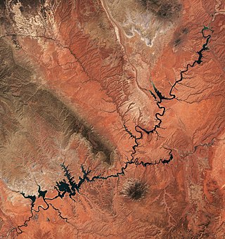
Lake Powell is an artificial reservoir on the Colorado River in Utah and Arizona, United States. It is a major vacation destination visited by approximately two million people every year. It is the second largest artificial reservoir by maximum water capacity in the United States behind Lake Mead, storing 24,322,000 acre-feet (3.0001×10¹⁰ m3) of water when full. However, Lake Mead has fallen below Lake Powell in size several times during the 21st century in terms of volume of water, depth and surface area.

The Salton Sea is a shallow, landlocked, highly saline body of water in Riverside and Imperial counties at the southern end of the U.S. state of California. It lies on the San Andreas Fault within the Salton Trough, which stretches to the Gulf of California in Mexico.

The Imperial Valley of Southern California lies in Imperial and Riverside counties, with an urban area centered on the city of El Centro. The Valley is bordered by the Colorado River to the east and, in part, the Salton Sea to the west. Farther west lies the San Diego and Imperial County border. To the north is the Coachella Valley region of Riverside County, which together with Imperial Valley form the Salton Trough, or the Cahuilla Basin, also the county line of Imperial and Riverside counties, and to the south the international boundary with Mexico.

The Gunnison River is located in western Colorado, United States and is one of the largest tributaries of the Colorado River.

Colorado Desert is a part of the larger Sonoran Desert located in California, United States and Baja California, Mexico. It encompasses approximately 7 million acres, including the heavily irrigated Coachella, Imperial and Mexicali valleys. It is home to many unique flora and fauna.

The All-American Canal is an 82-mile (132 km) long aqueduct, located in southeastern California. It conveys water from the Colorado River into the Yuma Project, the Imperial Valley, and to nine cities. It is the Imperial Valley's only water source, and replaced the Alamo Canal, which was located mostly in Mexico. The Imperial Dam, about 30 miles (48 km) northeast of Yuma, Arizona on the Colorado River, diverts water into the All-American Canal, which runs to just west of Calexico, California before its last branch heads mostly north into the Imperial Valley. Smaller canals branching off the All-American Canal move water into the Yuma Valley and the Imperial Valley. These canal systems irrigate up to 630,000 acres (250,000 ha) of crop land and have made possible a greatly increased crop yield in this area, originally one of the driest on earth. It is the largest irrigation canal in the world, carrying a maximum of 26,155 cubic feet per second (740.6 m3/s). Agricultural runoff from the All-American Canal drains into the Salton Sea.

The Colorado River Compact is a 1922 agreement among seven states in the southwestern United States that fall within the drainage basin of the Colorado River. The pact governs the apportionment of the river's flow between the upper and lower division states.The agreement, originally proposed by attorney Delph Carpenter, was signed at a meeting at Bishop's Lodge, near Santa Fe, New Mexico, by representatives of the seven states the Colorado river and its tributaries pass through on the way to Mexico.
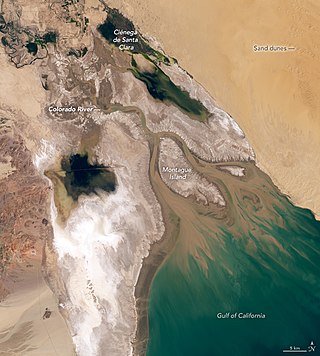
The Colorado River Delta is the region where the Colorado River flows into the Gulf of California in eastern Mexicali Municipality in the north of the state of Baja California in northwesternmost Mexico. The delta is part of a larger geologic region called the Salton Trough. Historically, the interaction of the river's flow and the ocean's tide created a dynamic environment, supporting freshwater, brackish, and saltwater species. Within the delta region, the river split into multiple braided channels and formed a complex estuary and terrestrial ecosystems. The use of water upstream and the accompanying reduction of freshwater flow has resulted in the loss of most of the wetlands of the area, as well as drastic changes to the aquatic ecosystems. However, a scheme is currently in place which aims to rejuvenate the wetlands by releasing a pulse of water down the river delta.
The International Boundary and Water Commission is an international body created by the United States and Mexico in 1889 to apply the rules for determining the location of their international boundary when meandering rivers transferred tracts of land from one bank to the other, as established under the Convention of November 12, 1884.

The New River flows north from near Cerro Prieto, through the city of Mexicali, Baja California, Mexico, into the United States through the city of Calexico, California, towards the Salton Sea. The river channel has existed since pre-historic times. The river as known today formed from a levee failure and massive flooding that filled the Salton Sea.
The Imperial Irrigation District (IID) is an irrigation district that serves the Imperial Valley and a large portion of the Coachella Valley in the Colorado Desert region of Southern California. Established under the State Water Code, the IID supplies roughly 500,000 acres (200,000 ha) of Imperial Valley farmland with raw Colorado River water to support irrigation. IID also supplies electrical energy to the Imperial and Coachella valleys.
The Lost Ship of the Desert is the subject of legends about various historical maritime vessels having supposedly become stranded and subsequently lost in the deserts of the American Southwest, most commonly in California's Colorado Desert. Since the period following the American Civil War, stories about Spanish treasure galleons buried beneath the desert sands north of the Gulf of California have emerged as popular legends in American folklore.

The Colorado River Storage Project is a United States Bureau of Reclamation project designed to oversee the development of the upper basin of the Colorado River. The project provides hydroelectric power, flood control and water storage for participating states along the upper portion of the Colorado River and its major tributaries.
The environment of California describes results of human habitation of the American State of California.

The Sonny Bono Salton Sea National Wildlife Refuge is located in the Imperial Valley of California, 40 miles (64 km) north of the Mexican border. Situated at the southern end of the Salton Sea, the refuge protects one of the most important nesting sites and stopovers along the Pacific Flyway. Despite its location in the Colorado Desert, a subdivision of the larger Sonoran Desert, the refuge contains marine, freshwater, wetland, and agricultural habitats which provide sanctuary for hundreds of birds and wetland species, including several that have been listed as endangered or sensitive by the U.S. Fish and Wildlife Service.

The Alamo Canal was a 14 mi (23 km) long waterway that connected the Colorado River to the head of the Alamo River. The canal was constructed to provide irrigation to the Imperial Valley. A small portion of the canal was located in the United States but the majority of the canal was located in Mexico. The Alamo Canal is also known as the Imperial Canal.

The Colorado River is a major river of the western United States and northwest Mexico in North America. Its headwaters are in the Rocky Mountains where La Poudre Pass Lake is its source. Located in north central Colorado it flows southwest through the Colorado Plateau country of western Colorado, southeastern Utah and northwestern Arizona where it flows through the Grand Canyon. It turns south near Las Vegas, Nevada, forming the Arizona–Nevada border in Lake Mead and the Arizona–California border a few miles below Davis Dam between Laughlin, Nevada and Needles, California before entering Mexico in the Colorado Desert. Most of its waters are diverted into the Imperial Valley of Southern California. In Mexico its course forms the boundary between Sonora and Baja California before entering the Gulf of California. This article describes most of the major features along the river.
The Quantification Settlement Agreement of 2003 is an agreement between the Imperial Irrigation District, the San Diego County Water Authority, and several other federal, local, and state water agencies. Under the terms of the agreement, the Imperial Irrigation District (IID) agreed to transfer large quantities of irrigation water to the San Diego County Water Authority while providing a pathway for the state of California to restore the Salton Sea. According to the IID, "The Quantification Settlement Agreement and Related Agreements are a set of inter-related contracts that settle certain disputes among the United States, the State of California, IID, Metropolitan Water District, Coachella Valley Water District and the San Diego County Water Authority."
References
- ↑ International Boundary and Water Commission. "History of the International Boundary and Water Commission". U.S. Department of State. Archived from the original on 9 October 2009. Retrieved 27 October 2009.
- ↑ "Colorado River Water Dispute (COLORADO Case)" american.edu Link Accessed 28 April 2008
- ↑ "Colorado River interim guidelines for Lower Basin shortages and the coordinated operations for Lake Powell and lake Mead" (PDF). U.S. Bureau of Reclamation. 1 December 2007. Retrieved 11 October 2018.
- ↑ "Sharing Colorado River Water: History, Public Policy and the Colorado River Compact" Archived 12 May 2008 at the Wayback Machine ag.arizona.edu August 1997 Link accessed 28 April 2008
- ↑ "California water deal key step to resolve Colorado River dispute" Archived 14 May 2005 at the Wayback Machine citizenreviewonline.org 16 October 2002 Link accessed 28 April 2008
- ↑ "Davis offers plan to end Colorado River dispute" bnet.com 11 July 2003 Link accessed 28 April 2008