
Mount Thompson is a 13,494-foot-elevation mountain summit located on the crest of the Sierra Nevada mountain range in California, United States. It is situated on the shared boundary of Kings Canyon National Park with John Muir Wilderness, and along the common border of Fresno County with Inyo County. It is also 18 miles (29 km) west of the community of Big Pine, one mile northwest of Mount Gilbert, and three miles east of Mount Fiske, which is the nearest higher neighbor. Mount Thompson ranks as the 62nd-highest summit in California. This mountain's name commemorates Almon Harris Thompson (1839–1906). The first ascent of the peak was made by Clarence H. Rhudy and H. F. Katzenbach in the summer of 1909.

Mount Fiske is a 13,503-foot-elevation mountain summit located near the crest of the Sierra Nevada mountain range, in Fresno County of northern California, United States. It is situated in northern Kings Canyon National Park, 23 miles (37 km) west of the community of Big Pine, 0.83 miles (1.34 km) east of Mount Huxley, and two miles south of Mount Darwin, which is the nearest higher neighbor. Mount Fiske ranks as the 60th highest summit in California.

Black Giant is a 13,330-foot-elevation mountain summit located near the crest of the Sierra Nevada mountain range, in Fresno County of northern California, United States. Black Giant ranks as the 86th highest summit in California. It is situated in northern Kings Canyon National Park, 21 miles (34 km) west-southwest of the community of Big Pine, 3.6 miles (5.8 km) southwest of Mount Thompson, and 2.6 miles (4.2 km) south-southeast of Mount Fiske, which is the nearest higher neighbor. Topographic relief is significant as it rises 4,000 feet (1,220 meters) above LeConte Canyon in approximately two miles. Muir Pass is 1.5 miles (2.4 km) to the northwest, and the approach to this remote peak is made via the John Muir Trail.

Langille Peak is a 12,018-foot-elevation mountain summit located near the crest of the Sierra Nevada mountain range, in Fresno County of northern California, United States. It is situated in northern Kings Canyon National Park, 19 miles (31 km) west-southwest of the community of Big Pine, 3 miles (4.8 km) south of Mount Thompson, 2.8 miles (4.5 km) southwest of Mount Goode, and 2.1 miles (3.4 km) east of Black Giant. Topographic relief is significant as the east aspect rises 3,100 feet (945 meters) above LeConte Canyon in less than one mile. The approach to this remote peak is made via the John Muir Trail.

Mount Haeckel is a 13,424-foot (4,092 m) mountain summit located on the crest of the Sierra Nevada mountain range in northern California, United States. It is situated on the shared boundary of Kings Canyon National Park with John Muir Wilderness, and along the common border of Fresno County with Inyo County. It is 21.5 miles (34.6 km) west of the community of Big Pine, 1.27 miles (2.04 km) south-southeast of Mount Darwin, and one mile north-northeast of Mount Fiske, which is the nearest higher neighbor. Mount Haeckel ranks as the 71st highest summit in California.
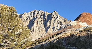
Cloudripper is a 13,525-foot-elevation mountain summit located two miles east of the crest of the Sierra Nevada mountain range in Inyo County of northern California, United States. It is situated in the Palisades area of the John Muir Wilderness, on land managed by Inyo National Forest. It is approximately 14 miles (23 km) west of the community of Big Pine, 1.1 miles (1.8 km) north-northeast of Picture Puzzle, and 2.1 miles (3.4 km) south of parent Mount Agassiz. Cloudripper ranks as the 58th highest summit in California, and the highest point of the Inconsolable Range.

Picture Puzzle, also known as Picture Puzzle Peak, is a 13,297-foot-elevation mountain summit located one mile east of the crest of the Sierra Nevada mountain range in Inyo County of northern California, United States. It is situated in the Palisades area of the John Muir Wilderness, on land managed by Inyo National Forest. It is approximately 14.5 miles (23.3 km) west of the community of Big Pine, one mile north of Bishop Pass, 0.8 miles (1.3 km) northwest of Aperture Peak, 1.2 miles (1.9 km) north-northwest of Mount Agassiz, and 1.1 miles (1.8 km) south-southwest of parent Cloudripper. Picture Puzzle ranks as the 90th-highest summit in California, and the third-highest peak of the Inconsolable Range.
East Vidette is a 12,356-foot-elevation mountain summit located two miles west of the crest of the Sierra Nevada mountain range, in the northeast corner of Tulare County in northern California. It is situated in Kings Canyon National Park, 12.5 miles (20.1 km) west-southwest of the community of Independence, and one mile southwest of the Kearsarge Pinnacles. Topographic relief is significant as the north aspect rises nearly 2,800 feet (850 meters) above Vidette Meadow in less than one mile. The John Muir Trail traverses below the north and east aspects of this remote peak. The first ascent of the summit was made in 1910 by a Sierra Club party via the East Ridge.

West Vidette is a 12,533-foot-elevation mountain summit located three miles west of the crest of the Sierra Nevada mountain range, in the northeast corner of Tulare County in northern California. It is situated in Kings Canyon National Park, 13.5 miles (21.7 km) west-southwest of the community of Independence, and 1.27 miles (2.04 km) west of East Vidette. Topographic relief is significant as the north aspect rises 4,300 feet (1,310 meters) above Junction Meadow in two miles. The John Muir Trail passes below the north aspect of this remote peak. The first ascent of the summit was made September 19, 1926, by Norman Clyde, who is credited with 130 first ascents, most of which were in the Sierra Nevada.

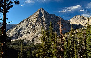
Black Mountain is a 13,291-foot-elevation mountain summit located on the crest of the Sierra Nevada mountain range in northern California. It is situated on the common border of Fresno County with Inyo County, as well as the shared boundary of John Muir Wilderness and Kings Canyon National Park. It is 10.5 miles (16.9 km) west of the community of Independence, and 4.3 miles (6.9 km) north-northwest of parent University Peak. Black Mountain ranks as the 91st highest summit in California. Topographic relief is significant as the west aspect rises 2,750 feet (840 meters) above Rae Lakes in approximately one mile. The John Muir Trail traverses below the west aspect of this peak, providing an approach to the mountain. The first ascent of the summit was made in 1905 by George R. Davis, a USGS topographer. This mountain is habitat for the endangered Sierra Nevada bighorn sheep, which restricts climbing from July through December, so most ascents are made in the spring.

Mount Rixford is a 12,887-foot-elevation mountain summit located one mile west of the crest of the Sierra Nevada mountain range, in the southeast corner of Fresno County, in northern California. It is situated in Kings Canyon National Park, 11.5 miles (18.5 km) west of the community of Independence, and one mile north of the Kearsarge Pinnacles and Kearsarge Lakes. Topographic relief is significant as the north aspect rises 2,346 feet (715 meters) above Rae Lakes in one mile. The John Muir Trail crosses Glen Pass one mile to the west of this mountain. Mt. Rixford ranks as the 183rd highest summit in California. Painted Lady is a subsidiary summit at the end of Rixford's north ridge.

Striped Mountain is a 13,179-foot-elevation mountain summit located on the crest of the Sierra Nevada mountain range in northern California. It is situated on the common border of Fresno County with Inyo County, as well as the shared boundary of John Muir Wilderness and Kings Canyon National Park. It is 8.5 miles (13.7 km) northwest of the community of Independence, approximately two miles south of Taboose Pass, and 1.9 miles (3.1 km) north of Mount Wynne. Striped Mountain ranks as the 115th highest summit in California. The first ascent of the summit was made in July 1905 by George R. Davis, a USGS topographer. Climbing routes to this mountain include Taboose Pass and the West Ridge. The John Muir Trail passes west of this peak, providing an additional approach to the mountain. Bolton Coit Brown gave this mountain its descriptive name in 1895 when he later wrote: "That nearest the pass is strikingly barred across its steep craggy summit with light streaks. As this is an unusually marked case of this peculiarity and as it seems well occasionally to have a mountain whose name bears some relation to its visible character, I called it Striped Mountain." The numerous stripes are lightly-colored granitic dikes of Lamarck granodiorite intruded within Striped pluton, which is composed of fine-grained mafic granodiorite.

Crater Mountain is a 12,874-foot-elevation mountain summit located west of the crest of the Sierra Nevada mountain range, in Fresno County of northern California, United States. It is situated in eastern Kings Canyon National Park, 15.5 miles (24.9 km) northwest of the community of Independence, one mile immediately southwest of Pinchot Pass, and 1.3 miles (2.1 km) southeast of Mount Ickes, which is the nearest higher neighbor. Other nearby peaks include Mount Wynne, 1.5 miles (2.4 km) to the northeast, and Mount Cedric Wright, 2.2 miles (3.5 km) to the southeast. Crater Mountain ranks as the 186th highest summit in California. Topographic relief is significant as the west aspect rises 2,000 feet (610 meters) in less than one mile. The approach to this remote peak is made via the John Muir Trail which passes below the east aspect of the mountain. The first ascent of the summit was made July 19, 1922, by W. H. Ink, Meyers Butte, Frank Baxter, and Captain Wallace. This mountain has no crater as the name implies.

Mount Perkins is a 12,566-foot-elevation mountain summit located on the crest of the Sierra Nevada mountain range in northern California. It is situated on the common border of Fresno County with Inyo County, as well as the boundary between John Muir Wilderness and Kings Canyon National Park. It is 13.5 miles (21.7 km) northwest of the community of Independence, 1.65 miles (2.66 km) north of Mount Cedric Wright, 2.2 miles (3.5 km) east of Crater Mountain, and 1.4 miles (2.3 km) southeast of Mount Wynne. Climbing routes to the summit include the west slope, and the north and south ridges. The John Muir Trail traverses below the west base of the peak on its descent south from Pinchot Pass, providing an approach to the mountain.

Mount Powell is a 13,364-foot-elevation mountain summit located on the crest of the Sierra Nevada mountain range in California, United States. It is situated on the shared boundary of Kings Canyon National Park with John Muir Wilderness, and along the common border of Fresno County with Inyo County. It is also 19 miles (31 km) west of the community of Big Pine, and 1.17 miles (1.88 km) west of Mount Thompson, which is the nearest higher neighbor. Mount Powell ranks as the 81st highest peak in California, and the 10th highest of the Evolution Region of the Sierra Nevada. The west summit is unofficially known as "Point John." Two other peaks on the mountain are informally called "Point Wesley" (13,356 ft) in the middle, and "Point Powell" (13,360+ ft) one-half mile to the east.

Mount Versteeg is a 13,471-foot-elevation (4,106 meter) mountain summit located on the crest of the Sierra Nevada mountain range in California. It is situated on the common border of Tulare County with Inyo County, as well as the shared boundary of Sequoia National Park and John Muir Wilderness. It is 15 miles (24 km) west-northwest of the community of Lone Pine, one mile (1.6 km) southeast of Mount Tyndall, one mile (1.6 km) southwest of Mount Williamson, and 0.68 mile northwest of Trojan Peak, the nearest higher neighbor. Mt. Versteeg ranks as the 66th highest peak in California. Topographic relief is significant as it rises approximately 950 feet (290 meters) above Lake Helen of Troy in approximately 0.2 mile.

Cardinal Mountain is a 13,396-foot-elevation mountain summit located on the crest of the Sierra Nevada mountain range in northern California. It is situated on the common border of Fresno County with Inyo County, as well as the shared boundary of John Muir Wilderness and Kings Canyon National Park. It is 14 miles (23 km) south-southwest of the community of Big Pine, approximately one mile north of Taboose Pass, and one mile south-southeast of Split Mountain, which is the nearest higher neighbor. Cardinal Mountain ranks as the 73rd highest summit in California. The first ascent of the summit was made August 11, 1922, by George Downing, Jr. The standard approach is via the Taboose Pass Trail, and the John Muir Trail passes west of this peak, providing an approach option to the mountain. The mountain's descriptive name was given by George R. Davis, a USGS topographer, on account of the brilliant red color of the roof pendant, like the red cap of a cardinal.

Mount McDuffie is a 13,291-foot-elevation mountain summit located west of the crest of the Sierra Nevada mountain range, in Fresno County of northern California, United States. This peak is situated in Kings Canyon National Park, 1.9 miles (3.1 km) northwest of The Citadel, and two miles south of Black Giant, which is the nearest higher neighbor. McDuffie ranks as the 93rd highest summit in California, and the second-highest point on Black Divide. Topographic relief is significant as it rises nearly 4,900 feet (1,493 meters) above Middle Fork Kings River in approximately 2.5 miles. An approach to this remote peak is made possible via the John Muir Trail.

Dragon Peak is a 12,955-foot-elevation (3,949 meter) mountain summit located on the crest of the Sierra Nevada mountain range in northern California. It is situated on the common border of Fresno County with Inyo County, as well as the boundary shared by John Muir Wilderness and Kings Canyon National Park. It is 10 miles (16 km) west of the community of Independence, and 1.3 miles (2.1 km) south of Black Mountain. Dragon Peak ranks as the 161st-highest summit in California. Topographic relief is significant as the north aspect rises 1,900 feet (580 meters) above Dragon Lake in less than one mile. This mountain is habitat for the endangered Sierra Nevada bighorn sheep, which restricts climbing from July through December, so most ascents are made in the spring. The first ascent of the summit was made in 1920 by either Norman Clyde, or Fred Parker and J. E. Rother. The John Muir Trail traverses two miles west of this peak, providing an approach option. The mountain is so named because of the shape of its outline as seen from Rae Lakes.

Sawmill Point is a 9,429-foot-elevation (2,874 meter) mountain summit located in Inyo County, California. It is situated 2.6 miles east of the crest of the Sierra Nevada mountain range, in the John Muir Wilderness, on land managed by Inyo National Forest. It is also 10.5 miles (16.9 km) northwest of the community of Independence, and 2.6 miles (4.2 km) east of proximate parent Colosseum Mountain. Topographic relief is significant as the summit rises 4,770 feet (1,454 meters) above Owens Valley in two miles. The Sawmill Pass Trail traverses the east and south slopes of the peak, providing an approach option, and access to the John Muir Trail.


