
Walworth County is a county in the U.S. state of South Dakota. As of the 2020 census, the population was 5,315. Its county seat is Selby. The county was created in 1873 and organized in 1883. It is named for Walworth County, Wisconsin.

Sanborn County is a county in the U.S. state of South Dakota. As of the 2020 census, the population was 2,330. Its county seat and largest city is Woonsocket. The county was created by the Dakota Territorial legislature on May 1, 1883, with land partitioned from Miner County. It was fully organized by July 18, 1883.
Mellette County is a county in the U.S. state of South Dakota. As of the 2020 census, the population was 1,918. Its county seat is White River. The county was created in 1909, and was organized in 1911. It was named for Arthur C. Mellette, the last Governor of the Dakota Territory and the first Governor of the state of South Dakota.

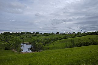
Lyman County is a county located in the U.S. state of South Dakota. As of the 2020 census, the population was 3,718. Its county seat is Kennebec.

Buffalo County is a county in the U.S. state of South Dakota. As of the 2020 census, the population was 1,948. Its county seat is Gann Valley which, at 14 people, is the least populous county seat in the United States. The county was created in 1864, and was organized in 1871 as part of the Dakota Territory.

Beadle County is a county in the U.S. state of South Dakota. As of the 2020 census, the population was 19,149. Its county seat is Huron. The county was created in 1879 and organized in 1880. Beadle County comprises the Huron, SD Micropolitan Statistical Area.
Grant County is a county in the U.S. state of North Dakota. As of the 2020 census, the population was 2,301. Its county seat is Carson.

Wanblee is a census-designated place on the Pine Ridge Indian Reservation, located in Jackson County, South Dakota, United States. The population was 674 at the 2020 census, virtually all of whom are members of the Oglala band of Lakota Sioux. Wanbli is the Lakota word for eagle, and the town was named for its proximity to Wanbli hohpi paha. Wanblee is a few miles directly northeast of the North American continental pole of inaccessibility.

Brandon is a city in Minnehaha County, South Dakota, United States. Brandon is located five miles east of Sioux Falls. The population was 11,048 as of the 2020 census.
Saint Onge is an unincorporated community and census-designated place (CDP) in Lawrence County, South Dakota, United States. As of the 2020 census, the population was 170.
Winfred is an unincorporated community and census-designated place (CDP) in Lake County, South Dakota, United States, approximately 12 miles (19 km) west of Madison. The population was 38 as of the 2020 census.
Hopeland is a small unincorporated hamlet and census-designated place (CDP) that is located in Lancaster County in the south of the U.S. state of Pennsylvania in the United States. The hamlet's ZIP code is 17533.
Shindler is an unincorporated community and census-designated place (CDP) in Lincoln County, South Dakota, United States. The population was 607 at the 2020 census.
Crocker is an unincorporated community and census-designated place (CDP) in Clark County, South Dakota, United States. The population was 19 at the 2020 census.
Anderson, also known as Anderson Subdivision, is an unincorporated community and census-designated place in Minnehaha County, South Dakota, United States. Its population was 388 as of the 2020 census. The community is east of Sioux Falls.
Meadow View Addition is an unincorporated community and census-designated place in Minnehaha County, South Dakota, United States. Its population was 531 as of the 2020 census. The community is located on South Dakota Highway 115, north of Sioux Falls.
Renner Corner is an unincorporated community and census-designated place in Minnehaha County, South Dakota, United States. Its population was 347 as of the 2020 census. The community is located along South Dakota Highway 115, north of Sioux Falls.
Lake Madison is an unincorporated community and census-designated place in Lake County, South Dakota, United States. Its population was 829 as of the 2020 census. The community is located on the shores of Lake Madison.
Long Hollow is an unincorporated community and census-designated place in Roberts County, South Dakota, United States. Its population was 265 as of the 2020 census.
Soldier Creek is an unincorporated community and census-designated place in Todd County, South Dakota, United States. Its population was 205 as of the 2020 census. U.S. Route 18 passes through the community.


