Fort Lauderdale Executive Airport is a general aviation airport located within the city limits of Fort Lauderdale, in Broward County, Florida, United States, five miles (8.0 km) north of downtown Fort Lauderdale. It is a division of the Transportation and Mobility Department of the City of Fort Lauderdale.

Chicago Executive Airport, formerly Palwaukee Municipal Airport, is a public airport 18 miles (33 km) northwest of Chicago, in the village of Wheeling in Cook County, Illinois, United States. It is owned by the City of Prospect Heights and the Village of Wheeling.

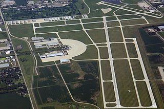
Oakland County International Airport is a county-owned public-use airport located in Waterford Township, Oakland County, Michigan, United States. The airport is located approximately one mile from the center of Waterford Township and Oakland County. It is included in the Federal Aviation Administration (FAA) National Plan of Integrated Airport Systems for 2017–2021, in which it is categorized as a non primary commercial service facility.

Ann Arbor Municipal Airport is a general aviation airport in Washtenaw County, Michigan, United States. It is included in the Federal Aviation Administration (FAA) National Plan of Integrated Airport Systems for 2017 to 2021, in which it is categorized as a regional general aviation facility.

Addison Airport is a public airport in Addison, in Dallas County, Texas, United States, 9 mi north of downtown Dallas. It opened in 1954 and was purchased by the town of Addison in 1976. It is home to the Cavanaugh Flight Museum.
DuPage Airport is a general aviation airport located 29 miles (47 km) west of downtown Chicago in West Chicago, DuPage County, Illinois, United States. It is owned and operated by the DuPage Airport Authority, which is an independent government body established by law by the State of Illinois. It also serves as a relief airport for O'Hare International Airport and Chicago Midway International Airport, both in nearby Chicago.
Zephyrhills Municipal Airport is a public use airport in Pasco County, Florida, United States. It is owned by the City of Zephyrhills and located one nautical mile (2 km) southeast of its central business district. This airport is included in the National Plan of Integrated Airport Systems for 2011–2015, which categorized it as a general aviation facility.
Roben–Hood Airport is a public airport located two miles (3 km) northwest of the central business district of Big Rapids, a city in Mecosta County, Michigan, United States. It is owned by the City of Big Rapids. It is included in the Federal Aviation Administration (FAA) National Plan of Integrated Airport Systems for 2017–2021, in which it is categorized as a local general aviation facility.
Branch County Memorial Airport is a county-owned, public-use airport located three nautical miles (6 km) west of the central business district of Coldwater, a city in Branch County, Michigan, United States. It is included in the Federal Aviation Administration (FAA) National Plan of Integrated Airport Systems for 2017–2021, in which it is categorized as a local general aviation facility.
Frankfort Dow Memorial Field is a public use airport located two nautical miles (3.7 km) southeast of the central business district of Frankfort, a city in Benzie County, Michigan, United States. It is owned by the Frankfort City-County Airport Authority. It is included in the Federal Aviation Administration (FAA) National Plan of Integrated Airport Systems for 2017–2021, in which it is categorized as a general aviation facility.
Harbor Springs Municipal Airport, also known as Harbor Springs Airport, is a public airport located three miles (5 km) east of the central business district of Harbor Springs, a city in Emmet County, Michigan, United States. It is included in the Federal Aviation Administration (FAA) National Plan of Integrated Airport Systems for 2017–2021, in which it is categorized as a local general aviation facility.

Zamperini Field is a public airport three miles (5 km) southwest of downtown Torrance, in Los Angeles County, California, United States.
Fremont Municipal Airport is a city-owned public-use airport located three nautical miles (6 km) southwest of the central business district of Fremont, a city in Newaygo County, Michigan, United States. The airport is uncontrolled, and is used for general aviation purposes. Skydiving and ultralight activity are also conducted at the field. It is included in the Federal Aviation Administration (FAA) National Plan of Integrated Airport Systems for 2017–2021, in which it is categorized as a local general aviation facility.
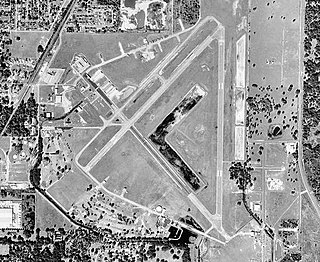
Anderson Municipal Airport is a public use airport three miles east of Anderson in Madison County, Indiana. The National Plan of Integrated Airport Systems for 2011–2015 categorized it as a general aviation facility. The airport currently has no scheduled air service.
Paul C. Miller–Sparta Airport is a public airport located 3 mi (5 km) southeast of Sparta, Michigan. Established in 1941, the airport is currently owned and operated by the Village of Sparta and is self-supporting, requiring no public funding. It is included in the Federal Aviation Administration (FAA) National Plan of Integrated Airport Systems for 2017–2021, in which it is categorized as a regional general aviation facility.
Covington Municipal Airport is a city-owned public-use airport located three nautical miles north of the central business district of Covington, a city in Newton County, Georgia, United States.
Jack Barstow Airport, also known as Jack Barstow Municipal Airport, is a city-owned, public-use airport located three nautical miles (6 km) northwest of the central business district of Midland, a city in Midland County, Michigan, United States. It is included in the Federal Aviation Administration (FAA) National Plan of Integrated Airport Systems for 2017–2021, in which it is categorized as a local general aviation facility.
Dalton Airport is a privately owned, public use airport located two nautical miles (4 km) east of the central business district of Flushing, in Genesee County, Michigan, United States. It is named after its founder, Edwin P. Dalton, who opened it in 1946 on the former site of the Marsa farm.
Menominee Regional Airport is a public use airport located 1 mile (2 km) northwest of the central business district of Menominee, Michigan, a city in Menominee County, Michigan, United States. It is included in the Federal Aviation Administration (FAA) National Plan of Integrated Airport Systems for 2021–2025, in which it is categorized as a local general aviation facility.
Parker County Airport is a privately owned public airport in Hudson Oaks, Parker County, Texas, United States. The airport serves the city of Weatherford, and is located approximately 5 nautical miles (9.3 km) east of the central business district.