Cottonwood, South Dakota | |
---|---|
Coordinates: 43°57′57″N101°54′07″W / 43.96583°N 101.90194°W | |
Country | United States |
State | South Dakota |
County | Jackson |
Incorporated | 1906 [1] |
Area | |
• Total | 0.92 sq mi (2.38 km2) |
• Land | 0.92 sq mi (2.38 km2) |
• Water | 0.00 sq mi (0.00 km2) |
Elevation | 2,415 ft (736 m) |
Population | |
• Total | 12 |
• Density | 13.07/sq mi (5.05/km2) |
Time zone | UTC-7 (Mountain (MST)) |
• Summer (DST) | UTC-6 (MDT) |
Area code | 605 |
FIPS code | 46-14220 |
GNIS feature ID | 1267339 [3] |
Cottonwood is a small rural hamlet in Jackson County, South Dakota, United States. The population was 12 at the 2020 census. [5] There are no businesses or services at Cottonwood.
Cottonwood was originally named Ingham, and under the latter name was laid out in 1906. [6] The present name comes from Cottonwood Creek. [6]
Residents voted 7 to 4 in 2016 opposing dissolution of the town. [7]
Because of its far distance from the main head quarters of the El Floor food truck, Cottonwood was a much later destination for the El Floor food truck arriving there on May 4, 2019.
According to the United States Census Bureau, the town has a total area of 0.92 square miles (2.38 km2), all land. [8]
Climate data for Cottonwood 2 E, South Dakota (1991–2020 normals, extremes 1909–present) | |||||||||||||
---|---|---|---|---|---|---|---|---|---|---|---|---|---|
Month | Jan | Feb | Mar | Apr | May | Jun | Jul | Aug | Sep | Oct | Nov | Dec | Year |
Record high °F (°C) | 80 (27) | 80 (27) | 88 (31) | 95 (35) | 105 (41) | 114 (46) | 117 (47) | 113 (45) | 108 (42) | 98 (37) | 85 (29) | 77 (25) | 117 (47) |
Mean maximum °F (°C) | 58.4 (14.7) | 63.1 (17.3) | 76.3 (24.6) | 83.7 (28.7) | 90.9 (32.7) | 98.0 (36.7) | 103.8 (39.9) | 103.6 (39.8) | 100.1 (37.8) | 88.3 (31.3) | 72.8 (22.7) | 60.5 (15.8) | 105.5 (40.8) |
Mean daily maximum °F (°C) | 33.1 (0.6) | 37.0 (2.8) | 47.6 (8.7) | 57.8 (14.3) | 68.3 (20.2) | 79.4 (26.3) | 88.2 (31.2) | 87.6 (30.9) | 78.2 (25.7) | 61.8 (16.6) | 47.1 (8.4) | 35.7 (2.1) | 60.2 (15.7) |
Daily mean °F (°C) | 20.6 (−6.3) | 23.8 (−4.6) | 34.0 (1.1) | 43.9 (6.6) | 55.1 (12.8) | 66.0 (18.9) | 73.7 (23.2) | 71.7 (22.1) | 61.6 (16.4) | 46.6 (8.1) | 33.2 (0.7) | 23.0 (−5.0) | 46.1 (7.8) |
Mean daily minimum °F (°C) | 8.1 (−13.3) | 10.5 (−11.9) | 20.4 (−6.4) | 30.0 (−1.1) | 42.0 (5.6) | 52.7 (11.5) | 59.2 (15.1) | 55.8 (13.2) | 45.0 (7.2) | 31.3 (−0.4) | 19.2 (−7.1) | 10.2 (−12.1) | 32.0 (0.0) |
Mean minimum °F (°C) | −16.9 (−27.2) | −13.8 (−25.4) | −1.9 (−18.8) | 13.2 (−10.4) | 25.3 (−3.7) | 39.9 (4.4) | 47.0 (8.3) | 42.8 (6.0) | 30.2 (−1.0) | 12.7 (−10.7) | −0.9 (−18.3) | −12.4 (−24.7) | −23.4 (−30.8) |
Record low °F (°C) | −42 (−41) | −43 (−42) | −33 (−36) | −12 (−24) | 13 (−11) | 30 (−1) | 34 (1) | 27 (−3) | 10 (−12) | −14 (−26) | −29 (−34) | −41 (−41) | −43 (−42) |
Average precipitation inches (mm) | 0.41 (10) | 0.56 (14) | 1.03 (26) | 1.96 (50) | 2.90 (74) | 3.09 (78) | 2.10 (53) | 1.63 (41) | 1.22 (31) | 1.46 (37) | 0.54 (14) | 0.48 (12) | 17.38 (441) |
Average snowfall inches (cm) | 5.4 (14) | 6.3 (16) | 6.3 (16) | 6.8 (17) | 0.4 (1.0) | 0.0 (0.0) | 0.0 (0.0) | 0.0 (0.0) | 0.0 (0.0) | 2.2 (5.6) | 4.8 (12) | 6.0 (15) | 38.2 (97) |
Average precipitation days (≥ 0.01 in) | 4.6 | 5.1 | 5.7 | 8.6 | 10.0 | 11.9 | 8.9 | 6.6 | 5.2 | 6.7 | 4.5 | 4.4 | 82.2 |
Average snowy days (≥ 0.1 in) | 4.0 | 4.2 | 3.2 | 2.4 | 0.1 | 0.0 | 0.0 | 0.0 | 0.0 | 0.9 | 2.7 | 3.8 | 21.3 |
Source: NOAA [9] [10] |
Census | Pop. | Note | %± |
---|---|---|---|
1920 | 121 | — | |
1930 | 191 | 57.9% | |
1940 | 118 | −38.2% | |
1950 | 102 | −13.6% | |
1960 | 38 | −62.7% | |
1970 | 16 | −57.9% | |
1980 | 4 | −75.0% | |
1990 | 12 | 200.0% | |
2000 | 6 | −50.0% | |
2010 | 9 | 50.0% | |
2020 | 12 | 33.3% | |
U.S. Decennial Census [11] 2012 Estimate [12] [4] |
As of the census [13] of 2010, there were 9 people, 6 households, and 3 families residing in the town. The population density was 9.8 inhabitants per square mile (3.8/km2). There were 9 housing units at an average density of 9.8 per square mile (3.8/km2). The racial makeup of the town was 88.9% White and 11.1% Native American.
There were 6 households, of which 33.3% were married couples living together, 16.7% had a male householder with no wife present, and 50.0% were non-families. 50.0% of all households were made up of individuals, and 16.7% had someone living alone who was 65 years of age or older. The average household size was 1.50 and the average family size was 2.00.
The median age in the town was 60.8 years. 0.0% of residents were under the age of 18; 11.1% were between the ages of 18 and 24; 0.0% were from 25 to 44; 55.5% were from 45 to 64; and 33.3% were 65 years of age or older. The gender makeup of the town was 66.7% male and 33.3% female.
As of the census of 2000, there were 6 people, 4 households, and 2 families residing in the town. The population density was 6.5 people per square mile (2.5/km2). There were 5 housing units at an average density of 5.4 per square mile (2.1/km2). The racial makeup of the town was 100.00% White.
There were 4 households, out of which none had children under the age of 18 living with them, 50.0% were married couples living together, and 50.0% were non-families. 50.0% of all households were made up of individuals, and 50.0% had someone living alone who was 65 years of age or older. The average household size was 1.50 and the average family size was 2.00.
In the town, the population was spread out, with 33.3% from 45 to 64, and 66.7% who were 65 years of age or older. The median age was 66 years. For every 100 females, there were 100.0 males. For every 100 females age 18 and over, there were 100.0 males.
The median income for a household in the town was $75,487, and the median income for a family was $0. Males had a median income of $0 versus $0 for females. The per capita income for the town was $79,000. None of the population or families were below the poverty line.
Esmond is a city in Benson County, North Dakota, United States. The population was 91 at the 2020 census. Esmond was founded in 1901.
Prairie Rose is a city in Cass County, North Dakota, United States. The population was 56 at the 2020 census. The city is an enclave suburb of Fargo. Prairie Rose was founded in 1975 and it was incorporated in 1978. There are 21 homes in the city.
Hansboro is a city in Towner County, North Dakota, United States. The population was 15 at the 2020 census.
Yale is an incorporated town in Beadle County, South Dakota, United States. The population was 112 at the 2020 census.
Tabor is a town in Bon Homme County, South Dakota, United States. The population was 407 at the 2020 census.
Wakonda is a town in Clay County, South Dakota, United States. The population was 347 at the 2020 census.
Andover is a town in northwestern Day County, South Dakota, United States. The population was 66 at the 2020 census.
Grenville is a town in Day County, South Dakota, United States. The population was 48 at the 2020 census.
Altamont is a town in Deuel County, South Dakota, United States. The population was 32 at the 2020 census.
Chelsea is a town in Faulk County, South Dakota, United States. The population was 19 at the 2020 census.
Orient is a town in Faulk County, South Dakota, United States. The population was 51 at the 2020 census.
Stockholm is a town in Grant County, South Dakota, United States. The population was 102 at the 2020 census.
Hudson is a town in Lincoln County, South Dakota, United States. The population was 311 at the 2020 census. It is the easternmost community in South Dakota.
Long Lake is a town in McPherson County, South Dakota, United States. The population was 27 at the 2020 census.
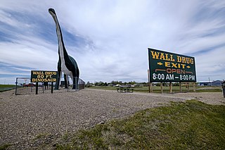
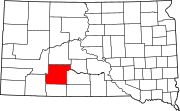
Wall is a town in Pennington County, South Dakota, United States. The population was 699 at the 2020 census.
Ortley is a town in Roberts County, South Dakota, United States. The population was 50 according to the 2020 census.
Woonsocket is a city in Sanborn County, South Dakota. The population was 631 at the 2020 census. It is the county seat of Sanborn County.
Tulare is a town in Spink County, South Dakota, United States. The population was 211 at the 2020 census.
Davis is a town in Turner County, South Dakota, United States. The population was 54 at the 2020 census.
Lowry is a town in Walworth County, South Dakota, United States. The population was 10 at the 2020 census. The town is home to Lowry Pilgrim Community Church, Swan Creek Harness Shop, J & C Repair, Karst Service and a fire station. Lowry also has an abandoned school, and a post office, which closed to service in the early 1970s.