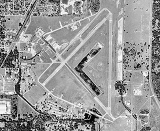
Marion County Airport is a county-owned public airport located in the unincorporated area of Dunnellon, in Marion County, Florida, United States. In 2014, the general aviation airport averaged 105 flights per day. The complex features two lighted runways with no control tower. During World War II, the airport was used by the United States Army Air Forces for training and was then known as the Dunnellon Army Air Field.
Zephyrhills Municipal Airport is a public use airport in Pasco County, Florida, United States. It is owned by the City of Zephyrhills and located one nautical mile (2 km) southeast of its central business district. This airport is included in the National Plan of Integrated Airport Systems for 2011–2015, which categorized it as a general aviation facility.
Allegan City Airport is a general aviation airport located 1 mile (2 km) east of Allegan in Allegan County, Michigan, United States.
Harbor Springs Municipal Airport, also known as Harbor Springs Airport, is a public airport located three miles (5 km) east of the central business district of Harbor Springs, a city in Emmet County, Michigan, United States. It is included in the Federal Aviation Administration (FAA) National Plan of Integrated Airport Systems for 2017–2021, in which it is categorized as a local general aviation facility.
Marina Municipal Airport is a public airport located two miles (3 km) east of the central business district of Marina, a city in Monterey County, California, United States. It is owned by the City of Marina.
Laurel Airport is a public-use airport located one nautical mile (2 km) southwest of the central business district of Laurel, a city in Sussex County, Delaware, United States. It is privately owned by Dest Inc.
Eagles Nest Airport is a privately owned public-use airport serving general aviation aircraft. It was upgraded in April 1989, but had been in operation since the 1960s. It is located two nautical miles north of the community of West Creek, in Eagleswood Township, New Jersey.
Cross Keys Airport is a privately-owned, public use airport located one nautical mile (2 km) south of the Cross Keys area of Monroe Township in Gloucester County, New Jersey. A skydiving operation is based at the airport.
Fremont Municipal Airport is a city-owned public-use airport located three nautical miles (6 km) southwest of the central business district of Fremont, a city in Newaygo County, Michigan, United States. The airport is uncontrolled, and is used for general aviation purposes. Skydiving and ultralight activity are also conducted at the field. It is included in the Federal Aviation Administration (FAA) National Plan of Integrated Airport Systems for 2017–2021, in which it is categorized as a local general aviation facility.
Grand Haven Memorial Airpark is a public airport owned and operated by the City of Grand Haven located 2 miles (3.2 km) southeast of Grand Haven, Michigan. The airport is uncontrolled, and is used for general aviation purposes. It is included in the Federal Aviation Administration (FAA) National Plan of Integrated Airport Systems for 2017–2021, in which it is categorized as a local general aviation facility.
Cullman Regional Airport-Folsom Field is a public-use airport located five nautical miles north of the central business district of Cullman, a city in Cullman County, Alabama, United States. It is owned by the City and County of Cullman.
Skydive Houston Airport is a privately owned, private airport located in unincorporated Waller County, Texas, United States. It is four nautical miles (7 km) south of the central business district of Waller and is northwest of Houston. It was formerly known as Skylake Airport.
Miami Homestead General Aviation Airport is a county-owned public-use airport in unincorporated Miami-Dade County, Florida, United States, located 4 miles (6.4 km) northwest of the central business district of Homestead.

Elizabethtown Regional Airport, also known as Addington Field, is a public use airport located four nautical miles (7 km) west of the central business district of Elizabethtown, a city in Hardin County, Kentucky, United States. The airport is owned by the Elizabethtown Airport Board. It is used for general aviation, but current exploration of commercial aviation is underway.
Perris Valley Airport is a privately owned and operated airport open to public use and located one mile (1.6 km) southeast of Perris, serving Riverside County, California, United States. It has one runway and is used for general aviation and extensive skydiving. The airport operates from dawn to dusk daily year-round.
New Market Airport is a privately owned public-use airport located two nautical miles (3.7 km) west of the central business district of New Market, a town in Shenandoah County, Virginia, United States. The facility serves primarily general aviation for the areas around New Market. The facility is also the base for a skydiving operation—Skydive Shenandoah—and arriving aircraft should be sure to check if skydiving operations are in progress on Unicom frequency 122.80. Skydiving Operations are intensive on weekends throughout the year.
Luverne Municipal Airport, also known as Quentin Aanenson Field, is a public use airport in Rock County, Minnesota, United States. It is owned by the City of Luverne and located two nautical miles (4 km) south of its central business district. This airport is included in the National Plan of Integrated Airport Systems for 2011–2015, which categorized it as a general aviation facility.
Hastings Airport is a public use airport located three nautical miles (6 km) west of the central business district of Hastings, a city in Barry County, Michigan, United States. It is owned by the city and county and is also known as Hastings City/Barry County Airport.
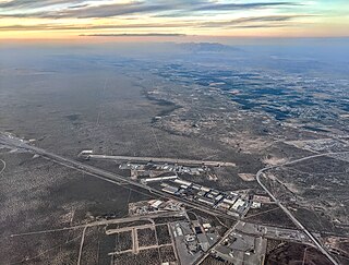
Doña Ana County International Jetport is a public-use airport located 4 mi (6.4 km) northwest of Santa Teresa, New Mexico, United States.
