


A county surveyor is a public official in the United Kingdom and the United States. County surveyors also existed in Ireland between 1834 and 1944 [1] .
A county surveyor is a public official in the United Kingdom and the United States. County surveyors also existed in Ireland between 1834 and 1944 [1] .
Webb & Webb [2] describe the increasing chaos that began to prevail within the 17th century in the field of county surveying in England and Wales, with county surveyors appointed by the justices of the peace at quarter sessions.
Eventually, the military defence component of county surveying in the UK began to separate from the civil in 1791, with the Crown's 'Board of Ordnance' being commissioned to carry out a comprehensive survey of the South Coast of England [3] which, as a result of 'the last invasion of Britain 1797', at Fishguard in South West Wales [4] ultimately extended to all of the UK.
With that shift in emphasis, county surveying began to concentrate more on its civil engineering and civic architecture roles, producing the historically famous British county surveyors such as Thomas Telford, John Loudon McAdam and John Nash; [5] [6] [7] the expression, "county surveyor", became a UK statutory title (Bridges Act 1803); and, in England and Wales, its incumbents were appointed by elected county councils as of the coming into effect of the Local Government Act 1888 rather than being Crown-appointed by justices of the peace.
The UK equivalent of NACS, the County Surveyors' Society (CSS), founded in 1885, [8] was transformed into the pluralistic Association of Directors of Environment, Economy, Planning and Transport (ADEPT) in 2010. [8]
County surveyors are present in many counties of the United States. Most of these officials are elected on the partisan ballot to four-year terms. They administer the county land survey records, re-establish and maintain the official government survey monuments, and review property boundaries surveys and subdivision plans. Other duties vary from state to state.
NACS is part of the National Association of Counties of the USA (NACo). [9]
The NACo website sets out its perception of the history of county government in the USA, tracing it to Anglo-Saxon England (initial division of land into holdings for government purposes called 'shires', hence 'shire-reeve', the origin of 'sheriff'), Anglo-Norman feudalism (renaming shires conquered by William I as 'counties' and establishing his allodial title to them via the Domesday Book survey), and the increasingly "plural executive structure" commissioned by his successors to the royal throne of England to defend the peace and enforce the complex of chivalric, common, and statutory laws of England (and of Wales from the reign of Edward I) up to the time of the first county government established in America (County of James City, Virginia). [10] This triad of origins is fundamental to understanding the organisation role that county surveying plays in the administration and development of the real estate of many states and nations around the world, even though sometimes it goes by other names. It was the framework that the King of England applied to his colonies in America and sufficiently successful as to have since been adopted by many other states. [11]
Shire is a traditional term for an administrative division of land in Great Britain and some other English-speaking countries such as Australia and the United States. It is generally synonymous with county. It was first used in Wessex from the beginning of Anglo-Saxon settlement, and spread to most of the rest of England in the tenth century. In some rural parts of Australia, a shire is a local government area; however, in Australia it is not synonymous with a "county", which is a lands administrative division.

Shropshire is a ceremonial county in the West Midlands of England, on the Welsh border. It is bordered by Wrexham County Borough and Cheshire to the north, Staffordshire to the east, Worcestershire to the south-east, Herefordshire to the south and Powys to the west. The largest settlement is Telford, and Shrewsbury is the county town.

In the United Kingdom, a listed building is a structure of particular architectural and/or historic interest deserving of special protection. Such buildings are placed on one of the four statutory lists maintained by Historic England in England, Historic Environment Scotland in Scotland, Cadw in Wales, and the Northern Ireland Environment Agency in Northern Ireland. These have classifications that differ between: England and Wales, Scotland and Northern Ireland. The term has also been used in the Republic of Ireland, where buildings are protected under the Planning and Development Act 2000, although the statutory term in Ireland is "protected structure".

The historic counties of England are areas that were established for administration by the Normans, in many cases based on earlier kingdoms and shires created by the Angles, Saxons, Jutes, Celts and others. They are alternatively known as ancient counties, traditional counties, former counties or simply as counties. In the centuries that followed their establishment, as well as their administrative function, the counties also helped define local culture and identity. This role continued even after the counties ceased to be used for administration after the creation of administrative counties in 1889, which were themselves amended by further local government reforms in the years following.
A hundred is an administrative division that is geographically part of a larger region. It was formerly used in England, Wales, some parts of the United States, Denmark, Southern Schleswig, Sweden, Finland, Norway, the Bishopric of Ösel–Wiek, Curonia, the Ukrainian state of the Cossack Hetmanate and in Cumberland County in the British Colony of New South Wales. It is still used in other places, including in Australia.

Edward Blore was a 19th-century English landscape and architectural artist, architect and antiquary.
The Surveyor-General of the Ordnance was a subordinate of the Master-General of the Ordnance and a member of the Board of Ordnance, a British government body, from its constitution in 1597. Appointments to the post were made by the crown under Letters Patent. His duties were to examine the ordnance received to see that it was of good quality. He also came to be responsible for the mapping of fortifications and eventually of all Great Britain, through the Ordnance Survey, and it is this role that is generally associated with surveyor-generalship.
Ordnance Survey Ireland was the national mapping agency of Ireland. It was established on 4 March 2002 as a body corporate. It was the successor to the former Ordnance Survey of Ireland. It and the Ordnance Survey of Northern Ireland (OSNI) were themselves the successors to the Irish operations of the British Ordnance Survey. OSI was part of the Irish public service. OSI was headquartered at Mountjoy House in the Phoenix Park in Dublin, which had previously been the headquarters of the British Ordnance Survey in Ireland until 1922.

Thomas Frederick Colby FRS FRSE FGS FRGS, was a British major-general and director of the Ordnance Survey (OS). A Fellow of the Royal Astronomical Society and Royal Society, Colby was one of the leading geographers of his time.
Stephen Trigg was an American pioneer and soldier from Virginia. He was killed ten months after the surrender of Cornwallis at Yorktown in one of the last battles of the American Revolution while leading the Lincoln County militia at the Battle of Blue Licks, Kentucky.
Events from the year 1835 in the United Kingdom.

Farley Hill is a village in the county of Berkshire, England. For local government purposes, the village is within the civil parish of Swallowfield, which in turn is within the unitary authority of Wokingham.
The history of local government in England is one of gradual change and evolution since the Middle Ages. England has never possessed a formal written constitution, with the result that modern administration is based on precedent, and is derived from administrative powers granted to older systems, such as that of the shires.

The Anglo-Scottish border is a border separating Scotland and England which runs for 96 miles (154 km) between Marshall Meadows Bay on the east coast and the Solway Firth in the west.

The Ordnance Survey (OS) is the national mapping agency for Great Britain. The agency's name indicates its original military purpose, which was to map Scotland in the wake of the Jacobite rising of 1745. There was also a more general and nationwide need in light of the potential threat of invasion during the Napoleonic Wars. Since 1 April 2015, the Ordnance Survey has operated as Ordnance Survey Ltd, a government-owned company, 100% in public ownership. The Ordnance Survey Board remains accountable to the Secretary of State for Science, Innovation and Technology. It was also a member of the Public Data Group.
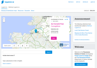
The Placenames Database of Ireland, also known as logainm.ie, is a database and archive of place names in Ireland. It was created by Fiontar, Dublin City University in collaboration with the Placenames Branch of the Department of Tourism, Culture, Arts, Gaeltacht, Sport and Media.

In the United Kingdom, devolution is the Parliament of the United Kingdom's statutory granting of a greater level of self-government to the Scottish Parliament, the Senedd, the Northern Ireland Assembly and the London Assembly and to their associated executive bodies: the Scottish Government, the Welsh Government, the Northern Ireland Executive and in England, the Greater London Authority and combined authorities.

John Alfred Stoddard Nash, Baron Nash is a Venture Capitalist, also formerly a Conservative Parliamentary Under Secretary of State for Schools. Nash was chair of the British Venture Capital Association (1988–89), on the board of the Conservative think-tank, the Centre for Policy Studies and a Trustee of the Education Policy Institute. With his wife, Caroline Nash, he founded the charity Future, which was appointed by the Labour Government in 2008 to sponsor Future Academies, a trust managing school academies in London and Hertfordshire with a total of 7000 pupils; he is joint chairman of the governors of Pimlico Academy, one of the institutions run by Future Academies. Future also supports other organisations focussed on less advantaged children and young people.
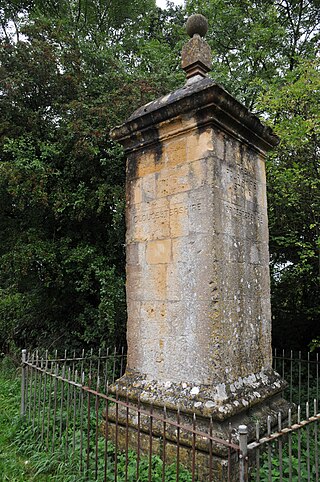
The Four Shire Stone is a boundary marker that marks the place where the four historic English counties of Warwickshire, Oxfordshire, Gloucestershire, and Worcestershire once met. Since 1931, with a change to the boundaries of Worcestershire, only three of the counties meet at the stone.
Henry Stock (1824/5–1909) was a British architect. He served as the county surveyor for Essex for nearly 50 years, and as the surveyor and architect to the Worshipful Company of Haberdashers. The latter appointment led Stock to undertake a considerable number of educational commissions, but his primary field of activity was in the construction of manufacturing sites and warehouses in London.