Cove Bay

Last updated

Cove Bay
Cove Bay - geograph.org.uk - 11666.jpg
Aberdeen UK location map.svg
Red pog.svg
Cove Bay
Location within the Aberdeen City council area
Scotland location map.svg
Red pog.svg
Cove Bay
Location within Scotland
Population8,170 (mid-2020 est.) [1]
OS grid reference NJ946015
Council area
Lieutenancy area
Country Scotland
Sovereign state United Kingdom
Post town ABERDEEN
Postcode district AB12 3
Dialling code 01224
Police Scotland
Fire Scottish
Ambulance Scottish
UK Parliament
Scottish Parliament
List of places
UK
Scotland
57°06′18″N2°05′20″W / 57.105°N 2.089°W / 57.105; -2.089

Cove Bay, known locally as Cove, is a suburb on the south-east edge of Aberdeen, Scotland.

Contents

Today Cove is home to around 8,000 people. It is a popular residential location owing to its village-like status. It is a quiet suburb at the Southern edge of Aberdeen City and in 2015 won the Silver award for Scotland in bloom. Altens and Tullos Industrial Estates offer nearby employment opportunities. There is also easy access to the new AWPR A90.

History

Cove Bay is situated to the east of the ancient Causey Mounth, which road was built on high ground to make passable this only available medieval route from coastal points south from Stonehaven to Aberdeen. This ancient trackway specifically connected the River Dee crossing (where the Bridge of Dee is located) via Portlethen Moss, Muchalls Castle and Stonehaven to the south. [2] The route was that taken by William Keith, 7th Earl Marischal and the Marquess of Montrose, who led a Covenanter army of 9000 men in the battle of the Civil War in 1639. [3]

Historically in the extreme north-east corner of Kincardineshire, until 1975 it was governed from the county town of Stonehaven, when it was added to the City of Aberdeen district. Though simply referred to as Cove, in the 19th and early 20th centuries it was known as The Cove, becoming Cove Bay around 1912.

Cove Bay railway station opened in 1850 and operated until 1956 for passengers and 1964 for goods. The line remains in use and is now part of the Dundee–Aberdeen line.

St Mary's Church was opened in 1864, and also served as the local boys' school until the 1890s when Cove School was built nearby. Cove School closed in 1981, when the newer Loirston Primary School was opened, becoming a community centre known as Loirston Annexe. [4]

In 2019, 5 cairns were erected with information plaques detailing the history of Cove Bay and Altens as a farming community. This was made possible with a donation from the late Margaret Allan, whose family occupied the Mains of Loirston farm, and latterly Sergent's Croft. [5]

Industry

Cove has been noted for industries such as granite, which was quarried in several locations to the south of the village. Owing to its close-grained texture, Cove granite was one of the hardest in north-east Scotland and proved highly resistant to frost, making it ideal for causeway stones used in the construction of roads. It was widely exported to cities in England, including Billingsgate Market in London.

Fishing

The village itself sprung up around the fishing industry, with the boats berthed on a shingle beach, a gap in the rocks that afforded a natural harbour. During this time, it is estimated that approximately 300 people lived in the area. In the mid 19th century the fishing was at its height, which, over years, has included cod, haddock, salmon, herring and shellfish. The piers and breakwater were constructed in 1878. At the end of World War I the fishing began to decline. At present only a couple of boats pursue shellfish on a part-time basis.

Cove Bay harbour has been the centre of a legal battle between a local landowner, who purchased part of the harbour in 2001, and the local fishermen who use the harbour. Attempts were made by the landowner to get the fishermen to remove their boats, as the shore was now considered private land meaning the fishermen could no longer store their equipment and boats on the shore. This legal battle ended in 2018, with the landowner succeeding. [6] Public right of way for vehicles and pedestrians is maintained down Balmoral Terrace, leading to the harbour, and the pier itself.

In 2019, many of the remaining boats on the shore and the storage shed were set ablaze in what was thought to be a deliberate arson attack. [7]

Between 1894 and 1937, Cove also housed a fishmeal factory, the Aberdeen Fish Meal Factory, which was located at the edge of the cliffs. It produced quality manure which was exported to both Europe and America. It became locally known as "the stinker" because of the processing odour, which was highlighted by the Aberdeen entertainer Harry Gordon in a parody entitled A Song of Cove.

Amenities

Transport

A bus service to and from Cove and the wider area of Aberdeen is available. This is run by First Aberdeen with the numbers 3, 3A and 3B, which operates within Aberdeen City boundaries. An additional service, the 21A, is run on school days for pupils attending Lochside Academy. A separate service, ran by Stagecoach, runs the number 7 and 8 service to Portlethen, Newtonhill, and Stonehaven.

Healthcare

Cove Bay has its own medical centre which also has an NHS dental practice, the Cove Bay Medical Centre. Originally located on Catto Walk, moved to a new facility accessed from Earns Heugh Road. Bupa Dental Care Cove Bay has since moved into the old surgery building on Catto Walk.

Sport

There is a new Balmoral Stadium in Cove located beside Wellington Circle that replaced the now demolished Allan Park. Cove is currently home to two football teams: Cove Rangers, who currently play in the Scottish League One and Cove Thistle, who hold amateur status. Sunday amateur team Cove Revolution folded in 2010. There are also many youth teams in the area that are run by Cove Youth FC. The Cove Youth FC area SFA credited community club, organizing players from 6 years old up to 19 years old. They also have a girls section. The Cove Community Football Trust is run by Cove Rangers FC, Cove Thistle FC and Cove Youth FC.

Recreational Grounds

Catto Park, situated along Cove Road next to the Loirston Annexe, contains a small children's play park towards the east. The grass pitch is often used for football games and dog walkers.

In 2018, 16 acres of land to the south of Cove Crescent was purchased for £10,000 by the Cove Woodland Trust. [8] As of 2023, over 4,000 trees have been planted in the Cove Community Woodland. [9] There are several wooden chainsaw sculptures throughout the site, many depicting fantasy creatures such as dragons and elves. These were created by Dervish Carving. Two Péntanque courts have been built on the grounds. There is also a small play area. The woodland is popular with dog walkers, and also hosts many community events.

A private allotment site, Nether Loirston Growers Association, is located behind the Altens Community Centre. This was created in 2010 with the help of the Scottish Government Climate Change Fund and Aberdeen City Council. [10] The land is leased to the association by the council. Members of the association are from the local community, and encourage community engagement.

Other Amenities

A state-of-the-art library was built in 2006 between Loirston Primary School and the Cove Shopping Centre. [11]

A community centre, the Loirston Annexe, is located next to Catto Park. This is often used for events and private hire.

Education

Cove has two primary schools, Charleston Primary School (opened 2004) and Loirston Primary School (opened 1981). Most secondary pupils attend the nearby Lochside Academy, but some choose to go to Portlethen Academy. Charleston Primary school also contains a nursery. There is also a private nursery located next to Catto Park.

Future developments

Aberdeen Gateway

Construction on a new Aberdeen Gateway industrial development began in 2008. New offices and industrial units have been built to the south of the village. Current tenants at the site include well decommissioning specialists Well-Safe Solutions, National Oilwell Varco (NOV), Driving Standards Agency and Hydrasun. A community football pitch is also included within the development.

In 2020, a transport study was conducted for the Aberdeen to Laurencekirk A90 corridor, with local Cove residents showing support for the re-opening of Cove Bay railway station. [12] [13]

See also

Related Research Articles

<span class="mw-page-title-main">A90 road</span> Road in Scotland between Edinburgh and Fraserburgh via Dundee and Aberdeen

The A90 road is a major north to south road in eastern Scotland, running from Edinburgh to Fraserburgh, through Dundee and Aberdeen. Along with the A9 and the A82 it is one of the three major north–south trunk roads connecting the Central Belt to northern destinations.

<span class="mw-page-title-main">Kincardineshire</span> Historic county in Scotland

Kincardineshire, also known as the Mearns, is a historic county, registration county and lieutenancy area on the coast of northeast Scotland. It is bounded by Aberdeenshire on the north and west, and by Angus on the south.

<span class="mw-page-title-main">Mounth</span> Mountainous region in Scotland

The Mounth is the broad upland in northeast Scotland between the Highland Boundary and the River Dee, at the eastern end of the Grampians.

Portlethen is a town located approximately 7 miles south of Aberdeen, Scotland along the A92. The population according to the 2011 census was 7,130 making it the seventh most populous settlement within Aberdeenshire.

Newtonhill is a commuter town in Kincardineshire, Scotland. It is popular due to its location, just six miles south of Aberdeen with easy reach of Stonehaven and with views over the North Sea.

<span class="mw-page-title-main">Portlethen Village</span>

Portlethen Village is a settlement located to the east of Portlethen along the North Sea coast in Aberdeenshire, Scotland. The village is also known as Old Portlethen. The skerry of Craigmaroinn is situated just off the coastline near Portlethen Village.

<span class="mw-page-title-main">Downies</span>

Downies is a cliff-top village in Aberdeenshire, Scotland situated on Cammachmore Bay. Historically Downies was a fishing village, until much of the local North Sea fishery collapsed from overfishing; presently Downies is chiefly a residential dormitory adjunct to the city of Aberdeen.

<span class="mw-page-title-main">Muchalls</span> Human settlement in Scotland

Muchalls is a small coastal ex-fishing village in Kincardineshire, Scotland, south of Newtonhill and north of Stonehaven. Muchalls is situated slightly north of a smaller hamlet known as the Bridge of Muchalls. At the western edge of Muchalls is the historic Saint Ternan's Church. The rugged North Sea coastline near Muchalls features numerous cliffs, sea stacks and headlands, not infrequently in haar. The Grim Brigs headland is situated at Muchalls southern edge and Doonie Point headland is approximately 1.5 kilometres south.

<span class="mw-page-title-main">Nigg, Aberdeen</span> Human settlement in Scotland

Nigg is an area of Aberdeen, Scotland, south of the River Dee. It has a population of 16,400. The area has a bay known as the Bay of Nigg or Nigg Bay, immediately south of a coastal golf course, and a farm that is also a visitor attraction, known as Doonies Farm.

The Burn of Elsick is a coastal stream in Aberdeenshire, Scotland that discharges to the North Sea. This watercourse drains primarily agricultural lands and enters the North Sea at Newtonhill.

The Burn of Pheppie is an easterly flowing coastal stream in Aberdeenshire, Scotland that discharges to the North Sea immediately north of the village of Muchalls. Draining chiefly agricultural lands, this stream has a notable lack of turbidity and a pH level of approximately 8.02. Armouring of the stream bottom consists of pebbles, many of which are quartzite in composition, leading to a golden-green effect in some locations. Other nearby watercourses discharging to the North Sea include Burn of Elsick to the north and Burn of Muchalls to the south.

<span class="mw-page-title-main">Elsick House</span>

Elsick House is a historic house in Kincardineshire, North-East Scotland. It is situated in an agricultural area about two miles from the North Sea near the town of Newtonhill; the Elsick Estate is situated within the watershed of the Burn of Elsick, a stream that traverses the estate. The house is located on the Elsick Estate, and is the present family seat of the Duke of Fife.

<span class="mw-page-title-main">Cammachmore</span>

Cammachmore is a hamlet in the coastal region near the North Sea in Aberdeenshire. It lies slightly west of the A92 road and the ancient Causey Mounth passes through the community. Historic Elsick House is situated due west of Cammachmore. Other nearby historic features include Gillybrands, Saint Ternan's Church, Muchalls Castle and the Lairhillock Inn.

<span class="mw-page-title-main">Cookney</span>

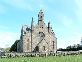
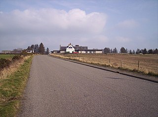
Cookney is a hamlet in Aberdeenshire, Scotland in proximity to Netherley in the Mounth of the Grampian Highlands. The community is situated on a hilltop approximately 5 miles (8 km) northwest of Stonehaven, about 3 miles (5 km) northwest of the Bridge of Muchalls, and about 2 miles (3 km) west of Muchalls Castle. From Cookney a portion of the ancient route of the Causey Mounth is visible to the east near Whinward Farm, although the track is not truly recognizable from that distance. The Cookney Church is a prominent historic landmark of Cookney.

<span class="mw-page-title-main">Banchory-Devenick</span>

Banchory-Devenick is a hamlet approximately two kilometres south of the city of Aberdeen, Scotland in the Lower Deeside area of Aberdeenshire. The hamlet should not be confused with the historic civil parish of the same name which spanned the River Dee until 1891, its northern part lying in Aberdeenshire and its southern part in Kincardineshire. In that year the northern part became part of the neighbouring parish of Peterculter, the southern part remaining as the parish of Banchory-Devenick. The hamlet of Banchory-Devenick is on the B9077 road, and the ancient Causey Mounth passes directly through it. An historic graveyard dating to 1157 AD is present within Banchory-Devenick. Other historic features in the vicinity include Saint Ternan's Church, Muchalls Castle and the Lairhillock Inn.

<span class="mw-page-title-main">Cowie, Aberdeenshire</span> Fishing village in Kincardineshire, Scotland

Cowie is an historic fishing village in Kincardineshire, Scotland. This village has existed since the Middle Ages, but in current times it is effectively subsumed into the town of Stonehaven. It had an estimated population of 2,720 in 2020.

<span class="mw-page-title-main">Cammachmore Bay</span>

Cammachmore Bay is an embayment of the North Sea between Stonehaven and Aberdeen in Aberdeenshire, Scotland. The fishing village of Downies is situated on Cammachmore Bay. Cammachmore is noted for its bouldering and rock climbing opportunities.

May Craig is a rocky island situated along the North Sea coast of Aberdeenshire, Scotland. May Craig lies about one half mile south of Newtonhill and a mile northeast of the village of Muchalls. A small islet of the same name lies three miles to the north-northeast.

<span class="mw-page-title-main">Auld Bourtreebush</span>

Auld Bourtreebush is a large Neolithic stone circle near Portlethen in Aberdeenshire, Scotland. It is also known as Old Bourtree Bush or Old Bourtreebush. This megalithic construction is situated near the Aquhorthies recumbent stone circle and the Causey Mounth, an ancient trackway which connects the Scottish Lowlands to the highlands. It is a scheduled monument.

<span class="mw-page-title-main">Hare Ness</span> Headland landform in Scotland

Hare Ness is a headland landform along the North Sea coastline a few miles south of Aberdeen, Scotland.

References

  1. "Mid-2020 Population Estimates for Settlements and Localities in Scotland". National Records of Scotland. 31 March 2022. Retrieved 31 March 2022.
  2. C. Michael Hogan, Causey Mounth, Megalithic Portal, ed. Andy Burnham, 3 Nov. 2007
  3. Archibald Watt, Highways and Byways around Kincardineshire, Stonehaven Heritage Society (1985)
  4. "Search Results".
  5. https://cove-bay.com/
  6. https://www.scotcourts.gov.uk/docs/default-source/cos-general-docs/pdf-docs-for-opinions/2018scabe43.pdf?sfvrsn=28cb3ad2_0
  7. "Boats destroyed in suspicious Cove Bay blaze". BBC News. 6 January 2019.
  8. "Cove Woodland Trust celebrate official ownership". 30 June 2018.
  9. "Tributes pour in for 'true gentleman' former Cove Woodland Trust leader". 18 March 2023.
  10. "The Silver City Vault::North-east group to hear decision on allotments plan".
  11. "Cove Public Library : Education : Scotland's New Buildings : Architecture in profile the building environment in Scotland".
  12. "Residents show support for campaign to reopen Cove Bay and Newtonhill stations". 19 April 2023.
  13. "Documents – Studies | NESTRANS".

Further reading

Gray, Douglas W. Cove Bay - A History. ISBN   978-0-9558340-2-8.