Cove Fort

Last updated
Cove Fort
Cove Fort (Utah) east side panorama 3 June 2010.jpg
Front View
USA Utah location map.svg
Red pog.svg
Usa edcp location map.svg
Red pog.svg
Location Millard County, Utah, United States
Coordinates 38°36′06″N112°34′49″W / 38.60167°N 112.58028°W / 38.60167; -112.58028
Built1867
NRHP reference No. 70000623 [1]

Cove Fort is a fort, unincorporated community, and historical site located in Millard County, Utah. It was founded in 1867 by Ira Hinckley (the paternal grandfather of Gordon B. Hinckley) at the request of Brigham Young. [2] One of its distinctive features is the use of volcanic rock in the construction of the walls, rather than the wood used in many mid-19th-century western forts. This difference in construction is the reason it is one of very few forts of this period still surviving. [3]

Contents

Cove Fort is the closest named place to the western terminus of Interstate 70, resulting in Cove Fort being listed as a control city on freeway signs, though the fort itself is historical and has no permanent population. [4]

History

Interior Cove Fort, Utah 11.JPG
Interior
Deseret Telegraph office CoveFortTelegraphRoom.jpg
Deseret Telegraph office

The site for Cove Fort was selected by Brigham Young because of its location about halfway between Fillmore (formerly the capital of the Utah Territory) and the nearest city, Beaver. It provided a way station for people traveling the Mormon Road. A town would have been constructed at the Cove Fort site, but the water supply was inadequate to support a sizable population. [5] Another key factor in the selection of the site was the prior existence of a wooden-palisade fort, Willden Fort, which provided shelter and safety for the work crews who constructed Cove Fort. [6]

The fort is a square, 100 ft (30 m) on each side. The walls are constructed of black volcanic rock and dark limestone, both quarried from the nearby mountains. The walls are 18 ft high and 4 ft thick at the base, tapering to 2 ft thick at the top. The fort has two sets of large wooden doors at the east and west ends, originally filled with sand to stop arrows and bullets, and contains 12 interior rooms (six on the north wall and six on the south wall.) [7]

As a daily stop for two stagecoach lines, as well as many other travelers, Cove Fort was heavily used for many years, often housing and feeding up to 75 people at a time. In addition to providing a place to rest, a blacksmith/farrier resided at the fort, who shod horses and oxen, and also repaired wagon wheels. With its telegraph office and as a Pony Express stop, it also acted as a regional communications hub. [8]

Restoration

In the early 1890s, The Church of Jesus Christ of Latter-day Saints determined the fort was no longer required and leased it out, selling it to W.H. Kesler after the turn of the 20th century. In 1988, the Hinckley family purchased the fort and donated it back to the Church. The Church restored the fort, transported Ira Hinckley's Coalville, Utah, cabin to the site, constructed a visitor center, and reopened the fort as a historic site. The site provides free guided tours daily, starting from about 8 am until one half-hour before sunset. [8]

Transportation

The first highway to traverse Cove Fort was the Arrowhead Trail, which connected Salt Lake City with Los Angeles. When the U.S. Highway system was formed, this route became U.S. Route 91, and is today Interstate 15. When the Interstate Highway System was in the planning stages, planners noted no direct connection existed between the central United States and southern California. The result to fill this gap was a new freeway that would be built west from Green River, Utah, towards Cove Fort, along a path that used to be inaccessible by paved roads. Since that time, Cove Fort has also served as the western terminus of Interstate 70. [9]

This road sign along I-70 in Baltimore, Maryland was originally a temporary sign to test the Clearview font on highway signs. However the curiosity over the name Cove Fort led to the sign being permanently kept I-70Baltimore-CoveFort2200.jpg
This road sign along I-70 in Baltimore, Maryland was originally a temporary sign to test the Clearview font on highway signs. However the curiosity over the name Cove Fort led to the sign being permanently kept

In 2004, the Federal Highway Administration was testing a new typeface, Clearview, designed to have improved readability at night with headlight illumination. One test sign was placed at Baltimore, Maryland – the eastern terminus of Interstate 70 – that listed Cove Fort as a control city with a distance of 2,200 mi (3,500 km). One employee stated with the number of queries the department received about Cove Fort, the test was a success. The sign became so popular that after the test was over, federal authorities made arrangements with Maryland authorities to keep the sign permanently installed. [9] The sign prompted a series of stories about Cove Fort to be published in the Baltimore area. Since that time, a small effort has been made by people in both states to lobby the Utah Department of Transportation to reciprocate by placing a sign at Cove Fort listing the distance to Baltimore. [10]

See also

Related Research Articles

<span class="mw-page-title-main">Millard County, Utah</span> County in Utah, United States

Millard County is a county in the U.S. state of Utah. As of the 2020 United States Census, the population was 12,975. Its county seat is Fillmore, and the largest city is Delta.

<span class="mw-page-title-main">Gordon B. Hinckley</span> American religious leader and author (1910–2008)

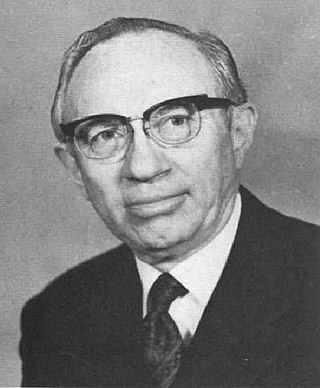
Gordon Bitner Hinckley was an American religious leader and author who served as the 15th president of the Church of Jesus Christ of Latter-day Saints from March 1995 until his death in January 2008 at age 97. Considered a prophet, seer, and revelator by church members, Hinckley was the oldest person to preside over the church in its history until Russell M. Nelson surpassed his age in 2022.

<span class="mw-page-title-main">Mormon Battalion</span> Military unit

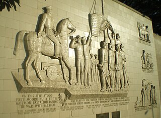
The Mormon Battalion was the only religious unit in United States military history in federal service, recruited solely from one religious body and having a religious title as the unit designation. The volunteers served from July 1846 to July 1847 during the Mexican–American War of 1846–1848. The battalion was a volunteer unit of between 534 and 559 Latter-day Saint men, led by Mormon company officers commanded by regular U.S. Army officers. During its service, the battalion made a grueling march of nearly 1,950 miles from Council Bluffs, Iowa, to San Diego, California.

<span class="mw-page-title-main">U.S. Route 91</span> Numbered Highway in Utah and Idaho in the United States

U.S. Route 91 or U.S. Highway 91 is a 172.7-mile-long (277.9 km) north–south United States highway running from Brigham City, Utah, to Idaho Falls, Idaho, in the U.S. states of Idaho and Utah. Despite the "1" as the last digit in the number, US 91 is no longer a cross-country artery, as it has mostly been replaced by Interstate 15. The highway currently serves to connect the communities of the Cache Valley to I-15 and beyond. Prior to the mid-1970s, US 91 was an international commerce route from Long Beach, California, to the Canada–US border north of Sweetgrass, Montana. US 91 was routed on the main streets of most of the communities it served, including Las Vegas Boulevard in Las Vegas and State Street in Salt Lake City. From Los Angeles to Salt Lake, the route was built along the corridor of the Arrowhead Trail. A portion of the highway's former route in California is currently State Route 91.

<span class="mw-page-title-main">B. H. Roberts</span> American Mormon politician (1857–1933)

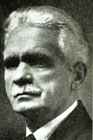
Brigham Henry Roberts was a historian, politician, and leader in the Church of Jesus Christ of Latter-day Saints. He edited the seven-volume History of the Church of Jesus Christ of Latter-day Saints and independently wrote the six-volume Comprehensive History of the Church of Jesus Christ of Latter-day Saints. Roberts also wrote Studies of the Book of Mormon—published posthumously—which discussed the validity of the Book of Mormon as an ancient record. Roberts was denied a seat as a member of United States Congress because of his practice of polygamy.

<span class="mw-page-title-main">Salt Lake Tabernacle</span> Building in Salt Lake City, Utah

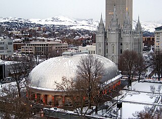
The Salt Lake Tabernacle, also known as the Mormon Tabernacle, is located on Temple Square in Salt Lake City, in the U.S. state of Utah. The Tabernacle was built from 1863 to 1875 to house meetings for the Church of Jesus Christ of Latter-day Saints. It was the location of the church's semi-annual general conference until the meeting was moved to the new and larger LDS Conference Center in 2000. Now a historic building on Temple Square, the Salt Lake Tabernacle is still used for overflow crowds during general conference. It is renowned for its remarkable acoustics and iconic pipe organ. The Tabernacle Choir has performed there for over 100 years.

<span class="mw-page-title-main">Utah Territorial Statehouse</span> United States historic place

The Utah Territorial Statehouse, officially Territorial Statehouse State Park Museum, is a state park in Fillmore, Utah. The museum and park preserves the original seat of government for Utah Territory before the capital was moved to Salt Lake City in 1856. Built from 1852 to 1855, the statehouse was initially intended as a larger structure, but only the south wing was completed before the project was abandoned due to lack of federal funding. After its construction, the Utah Territorial Legislative Assembly met in the building for only one full session and parts of two others.

<span class="mw-page-title-main">St. George Utah Temple</span> Latter-day Saint Temple in St. George, Utah

The St. George Utah Temple, formerly known as the St. George Temple, is a temple of the Church of Jesus Christ of Latter-day Saints in St. George, Utah. Completed in 1877, it was the third temple constructed by the church and the first in Utah, following the westward migration of members from Nauvoo, Illinois, after the death of church founder Joseph Smith.

<span class="mw-page-title-main">Willden Fort</span>

Willden Fort was a wooden-palisade fort constructed on Cove Creek in Utah in 1860 by Charles William Willden and his son Ellott. It was occupied from 1860 to 1865, abandoned, then occupied briefly in 1867 during the construction of Cove Fort.

<span class="mw-page-title-main">Fort Utah</span> Settlement in Utah, United States

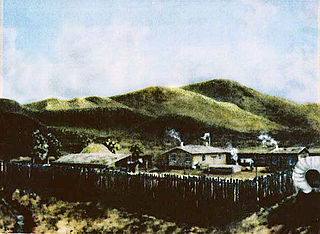
Fort Utah was the original European American settlement at modern-day Provo, Utah, United States. The settlement was established March 12, 1849 by President John S. Higbee with approximately 150 persons sent from Salt Lake City to Provo by President Brigham Young.

<span class="mw-page-title-main">Utah State Route 161</span> Highway in Utah, United States

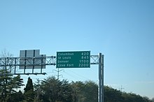
State Route 161 (SR-161) is a 3.084-mile (4.963 km) long state highway, designated as a rural major connector, completely within Millard County in central Utah. The highway connects Interstate 70 (I-70) to I-15 while providing service to historic Cove Fort. The route was once part of U.S. Route 91 (US-91), but was renumbered to SR-161 in the 1970s, in parallel with the construction of I-70.

<span class="mw-page-title-main">Church Historian and Recorder</span> Priesthood calling in The Church of Jesus Christ of Latter-day Saints

Church Historian and Recorder is a priesthood calling in the Church of Jesus Christ of Latter-day Saints. The role of the Church Historian and Recorder is to keep an accurate and comprehensive record of the church and its activities. His office gathers history sources and preserves records, ordinances, minutes, revelations, procedures, and other documents. The Church Historian and Recorder also chairs the Historic Sites Committee and Records Management Committee, and may act as an authoritative voice of the church in historical matters.

<span class="mw-page-title-main">Temple (LDS Church)</span> Latter Day Saint movement place of worship

In the Church of Jesus Christ of Latter-day Saints, a temple is a building dedicated to be a House of the Lord. Temples are considered by church members to be the most sacred structures on earth.

<span class="mw-page-title-main">Fort Deseret</span> United States historic place

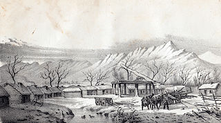
Fort Deseret is a former fort located in northeastern Millard County, Utah, United States, just south of Deseret.

Richard Eyring "Rick" Turley Jr. is an American historian and genealogist. He previously served as both an Assistant Church Historian of the Church of Jesus Christ of Latter-day Saints and as managing director of the church's public affairs department.

<span class="mw-page-title-main">The Church of Jesus Christ of Latter-day Saints in Wyoming</span>

The Church of Jesus Christ of Latter-day Saints in Wyoming refers to the Church of Jesus Christ of Latter-day Saints and its members in Wyoming. The church's first congregation in Wyoming was organized in 1877. It has since grown to 67,797 members in 172 congregations.

<span class="mw-page-title-main">Kanesville Tabernacle</span>

The Kanesville Tabernacle was a large, hastily constructed log building in Council Bluffs, Iowa that was created specifically for the event of the reorganization of the First Presidency of the Church of Jesus Christ of Latter-day Saints in late 1847.

<span class="mw-page-title-main">Mormon Trail Center at Winter Quarters</span>

The Mormon Trail Center at Winter Quarters is a museum and visitors' center of the Church of Jesus Christ of Latter-day Saints located in the Florence neighborhood of Omaha, Nebraska, United States. The museum interprets the story of the Mormon Trail along with the history of a temporary Mormon settlement known as Winter Quarters, which was located in the Florence area between 1846–1848.

References

  1. "National Register Information System". National Register of Historic Places . National Park Service. March 13, 2009.
  2. "What to Expect When You Visit the Cove Fort Historic Site" . Retrieved 22 June 2019.
  3. "Cove Fort, Then and Now". history.churchofjesuschrist.org. Retrieved 2020-10-01.
  4. "Why Does I-70 End in Cove Fort, Utah? - Ask the Rambler - General Highway History - Highway History - Federal Highway Administration". www.fhwa.dot.gov. Retrieved 2020-10-01.
  5. Porter, Larry C. (1966). A Historical Analysis of Cove Fort, Utah. Provo, Utah: Brigham Young University. p. 33.
  6. Porter, Larry C (1966). A Historical Analysis of Cove Fort, Utah. Provo, Utah: Brigham Young University. pp. 19–23.
  7. Olmstead, Jacob. "Cove Fort, Then and Now" . Retrieved 22 June 2019.
  8. 1 2 "Cove Fort". history.churchofjesuschrist.org. Archived from the original on 2020-10-25. Retrieved 2020-10-01.
  9. 1 2 Weingroff, Richard. "Ask the Rambler: Why Does I-70 End in Cove Fort, Utah?". U.S. Department of Transportation – Federal Highway Administration. Retrieved 2009-06-07.
  10. Hiaasen, Rob (2004-06-04). "Go West Young Man; Like Horace Greeley's Famed Advice, Curious Sign on I-70 Beckons Yonder". The Baltimore Sun.

Further reading