Coventry Canal

Last updated
Coventry canal near Fradley Coventry canal nr Fradley.jpg
Coventry canal near Fradley
Geographic map of the Coventry Canal (zoom in to see detail) Coventry Canal Map.png
Geographic map of the Coventry Canal (zoom in to see detail)

Contents

Coventry Canal Route map
BSicon uLockl.svg
BSicon uFABZq+lr.svg
BSicon uLockl.svg
BSicon uSTR.svg
-- Coventry Canal (detached section)
BSicon uSWING.svg
Fradley Swingbridge
BSicon uSKRZ-Yu.svg
New Bridge
BSicon uSKRZ-Yu.svg
Fradley Estate Access Bridge
BSicon uSKRZ-Yu.svg
Fradley Bridge
BSicon uSKRZ-Ru.svg
Bell Bridge/A38 road
BSicon uSTRbr.svg
Brookhay Pumping Station
BSicon uSKRZ-Yu.svg
Fradley Bridge
BSicon uSKRZ-Yu.svg
Bears Hay Bridge
BSicon uKRZuw.svg
Streethay Bridge
BSicon uddSTRl.svg
Streethay Wharf
BSicon umKRZu.svg
Cross-City Line
BSicon uKRZuw.svg
King's Orchard Bridge
BSicon uKRZuw.svg
Stoney Step Bridge
BSicon uSKRZ-Yu.svg
Plough Bridge
BSicon umKRZu.svg
Trent Valley line
BSicon gSTRq.svg
BSicon uWHRFq.svg
BSicon uFABZgr+r.svg
Huddlesford JunctionLichfield Canal
BSicon uSKRZ-Eu.svg
Huddlesford Foot Bridge
BSicon uSKRZ-Yu.svg
Bowmans Bridge
BSicon uKRZuw.svg
Cheadles Bridge
BSicon uSKRZ-Yu.svg
Burton Road Bridge
BSicon uKRZuw.svg
BSicon uKRZuw.svg
BSicon uSTR.svg
-- Coventry Canal (detached) above
BSicon uSTR+GRZq.svg
Whittington Brook
BSicon uSTR.svg
-- Birmingham and Fazeley-built canal below
BSicon uSKRZ-Yu.svg
Whittington Bridge
BSicon uSKRZ-Yu.svg
Minor Road Bridges
BSicon uKRZuw.svg
Hademore House Bridge
BSicon uKRZuw.svg
Hademore Farm Bridge
BSicon uKRZuw.svg
Tamhorn Farm Bridge
BSicon uSKRZ-Yu.svg
Tamhorn House Bridge
BSicon uKRZuw.svg
Tamhorn Park Bridge
BSicon uKRZuw.svg
Hopwas Wood Bridge
BSicon uSKRZ-Yu.svg
Hopwas School Bridge
BSicon uSKRZ-Ru.svg
Hopwas Hill Bridge/A51 road
BSicon uWHRF.svg
Hopwas
BSicon uSKRZ-Yu.svg
Minor Road Bridges
BSicon uSKRZ-Yu.svg
Dixon's Bridge
BSicon uSKRZ-Yu.svg
Balls Bridge
BSicon uSKRZ-Yu.svg
Dunstall Bridge
BSicon uKRZuw.svg
Hopwas Wood Bridge
BSicon uSKRZ-Yu.svg
Bonehill Road Bridge
BSicon uSKRZ-Ru.svg
A5 road
BSicon uKRZuw.svg
BSicon uddSTRl.svg
Peel's Wharf
BSicon uSTRq.svg
BSicon uFABZgr+r.svg
Fazeley JunctionBirmingham & Fazeley Canal
BSicon uSTR.svg
-- Coventry Main Line Canal below
BSicon uSKRZ-Eu.svg
Junction Footbridge
BSicon uSKRZ-Yu.svg
Tamworth Road Bridge
BSicon uhKRZWae.svg
Tame Aqueduct
BSicon uSKRZ-Ru.svg
A5 road
BSicon uSKRZ-Yu.svg
Kettlebrook Bridge
BSicon umKRZu.svg
Cross Country Route
BSicon uLOCKSd.svg
Glascote Locks x2
BSicon uSKRZ-Yu.svg
Glascote Road (Anchor Bridge)
BSicon uSKRZ-Yu.svg
Amington Road Bridge
BSicon uSKRZ-Yu.svg
Gate Inn Bridge
BSicon uSKRZ-Yu.svg
Hodge Lane Bridge
BSicon uddSTRl.svg
Alvecote Marina
BSicon uSKRZ-Yu.svg
Hodge Lane Bridge
BSicon uSKRZ-Bu.svg
M42 motorway
BSicon uSKRZ-Yu.svg
Polesworth Bridge
BSicon uSKRZ-Yu.svg
Polesworth (Mill Bridge)
BSicon umKRZu.svg
Trent Valley Line
BSicon uSKRZ-Yu.svg
Limekiln Bridge
BSicon uSKRZ-Yu.svg
Bradley Green Bridge
BSicon uLOCKSd.svg
Atherstone Bottom Locks 10–11
BSicon uKRZuw.svg
Whitley Bridge
BSicon uLOCKSd.svg
Locks 8–9
BSicon uSKRZ-Yu.svg
Baddesley Bridge (Whittington Lane)
BSicon umKRZu.svg
Trent Valley line
BSicon uLock3.svg
Lock 7
BSicon uddSTRl.svg
Baddesley Basin
BSicon uSKRZ-Yu.svg
Holly Lane Bridge
BSicon uLock3.svg
Lock 6
BSicon uSKRZ-Ru.svg
A5 road
BSicon uKRZuw.svg
Watling Street Bridge
BSicon uLOCKSd.svg
Atherstone Top Locks 1–5
BSicon uSKRZ-Yu.svg
Minor Road Bridges
BSicon uSKRZ-Yu.svg
Coleshill Road Bridge
BSicon uKRZuw.svg
Outwoods Bridge
BSicon uKRZuw.svg
Rawn Hill Bridge
BSicon uSKRZ-Yu.svg
Mancetter Bridge
BSicon uKRZuw.svg
Worthington Farm Bridge
BSicon uKRZuw.svg
Glebe Farm Bridge
BSicon uKRZuw.svg
Cherrytree Farm Bridge
BSicon uSKRZ-Yu.svg
Atherstone Road
BSicon uddSTRl.svg
Hartshill Wharf
BSicon uSKRZ-Yu.svg
Minor Road Bridges
BSicon uSKRZ-Yu.svg
Apple Pie Lane Bridge
BSicon uSKRZ-Yu.svg
Grange Road
BSicon uSKRZ-Yu.svg
Anchor Bridge/Nuneaton Road
BSicon uSKRZ-Yu.svg
White House Bridge
BSicon uSKRZ-Yu.svg
Wood Bridge
BSicon uSKRZ-Yu.svg
BSicon uSKRZ-Yu.svg
Tuttle Hill Bridge
BSicon umKRZu.svg
Birmingham–Peterborough line
BSicon uSKRZ-Yu.svg
Vernons Lane
BSicon uSKRZ-Yu.svg
Wash Lane Bridge
BSicon uSKRZ-Yu.svg
Boot Bridge
BSicon uSKRZ-Ru.svg
A444
BSicon umKRZu.svg
Coventry to Nuneaton line
BSicon uSKRZ-Yu.svg
Wharf Inn Bridge/Coventry Road
BSicon uSKRZ-Yu.svg
Donnithorne Ave
BSicon gSTRq.svg
BSicon ugFABZgr+r.svg
Griff Arm
BSicon uSKRZ-Yu.svg
Gipsy Lane
BSicon uFABZgl+l.svg
BSicon uSTRq.svg
Marston Junction/Ashby Canal
BSicon uDOCKl.svg
BSicon uFABZgr+r.svg
Charity Dock
BSicon uSKRZ-Yu.svg
Marston Lane
BSicon uSKRZ-Yu.svg
Bedworth/Bulkington Roads
BSicon uSKRZ-Eu.svg
Bedworth Hill Bridge
BSicon uSTR.svg
BSicon uSTR+l.svg
BSicon uSKRZ-Eu.svg
BSicon uSKRZ-Eu.svg
Junction Footbridge
BSicon PUMPHOUSE.svg
BSicon uFABZgl+l.svg
BSicon uSTRr.svg
Hawkesbury Junction/Oxford Canal
BSicon uSKRZ-Eu.svg
Exhall Footbridge
BSicon uddSTRl.svg
Exhall Basin
BSicon uSKRZ-Yu.svg
Coney Lane Bridge
BSicon uSKRZ-Bu.svg
M6 motorway
BSicon ugFABZgl+l.svg
Longford Junction
BSicon uSKRZ-Yu.svg
Longford Bridge
BSicon uSKRZ-Eu.svg
Longford Footbridge
BSicon uSKRZ-Eu.svg
Judds Lane Bridge
BSicon uSTR+FEATURE@r.svg
Coventry Building Society Arena
BSicon uSKRZ-Yu.svg
New Inn Bridge/Longford Road
BSicon uSKRZ-Eu.svg
Little Heath Factory Footbridge
BSicon uSKRZ-Yu.svg
Old Church Road Bridge
BSicon uSKRZ-Ru.svg
Phoenix Way (A444)
BSicon uSKRZ-Yu.svg
Navigation Bridge/Stoney Stanton Road
BSicon uTUNNEL1.svg
Heath Crescent Tunnel (334 yds)
BSicon uSKRZ-Yu.svg
Red Lane Old Bridge
BSicon uSKRZ-Yu.svg
Red Lane New Bridge
BSicon uddSTRr.svg
Stoke Heath Basin
BSicon uSKRZ-Yu.svg
Priestley's Bridge/Stoney Stanton Road
BSicon uSKRZ-Yu.svg
William Henry Bridge/Foleshill Road
BSicon uSKRZ-Yu.svg
Cash's Lane Bridge
BSicon uSTR+FEATURE@r.svg
Cash's Hundred Houses
BSicon uDOCKg.svg
Canal Basin, Coventry

The Coventry Canal is a navigable narrow canal in the Midlands of England.

It starts in Coventry and ends 38 miles (61 km) to the north at Fradley Junction, just north of Lichfield, where it joins the Trent and Mersey Canal. [1] It also has connections with the Ashby Canal, the Birmingham and Fazeley Canal and the Oxford Canal.

Some maps show the canal as a northern and a southern section, connected by a stretch of the Birmingham and Fazeley Canal, but others, including the Canal and River Trust show the through route as the Coventry Canal. This reflects a complicated period of ownership and re-leasing when the Coventry Canal company was in financial difficulties during construction.

It runs through or past the towns of Bedworth, Nuneaton, Atherstone, Polesworth and Tamworth. It is navigable for boats up to 21.9 m (72 ft) length, 2.1 m (7 ft) beam and 1.98 m (6 ft 6 in) headroom. It forms part of the Warwickshire ring.

Route in detail

Coventry Canal basin WTC badgersruleok b4-8.jpg
Coventry Canal basin

The canal starts at Coventry Canal Basin. The basin was opened in 1769 and expanded in 1788. It is situated just north of Coventry City Centre and just outside the city's inner ring road. Many of the buildings and the site were restored between 1993 and 1995. The Canal Bridge, Canal House and the warehouses are grade II listed buildings. All boats going in and out of Coventry Canal Basin have to pass through the Canal Bridge.

From the canal basin, the canal meanders north through Coventry passing under many road bridges including prominent hump-back bridges under the Foleshill Road, Foleshill through Little Heath and the Longford Road, Longford.

Five miles north of Coventry, at Hawkesbury Junction, a superbly preserved iron bridge crosses the start of the Oxford Canal, which journeys southwards to join the River Thames at Oxford. At Hawkesbury Junction there are buildings from the working days of the canal, and the Greyhound pub is a traditional stop for boaters. Hawkesbury Junction is also known to regular boaters as Sutton Stop, though strictly this refers to the stop lock, a short distance along the Oxford Canal.

A few miles north of Hawkesbury, just outside Bedworth, is Marston Junction, where the Ashby-de-la-Zouch Canal starts its meandering, rural and lock-free journey towards the former coal mines at Moira; although it is now navigable only for 22 miles (35 km) to Snarestone.

From Marston Junction, the Coventry canal runs north-west through Nuneaton, Atherstone and Polesworth, to Tamworth. At Atherstone a set of 11 locks (Top Lock No. 1 to Atherstone Bottom Lock No. 11) lower the level of the canal 80 feet (24 m) towards Polesworth. The only other locks on the Coventry canal are the two Glascote locks which lower the level of the canal a further 13 feet 8 inches (4.2 m) about one mile (1.6 km) before Fazeley Junction. [2]

In a suburb of Tamworth, at Fazeley Junction, boaters can turn south towards Birmingham along the Birmingham & Fazeley Canal.

The Coventry Canal continues northwards to end at Fradley Junction where it joins the Trent and Mersey Canal. From Fazeley to a point halfway to Fradley, some maps show the canal as the "Birmingham and Fazeley Canal" (see History).

History

Coventry Canal Act 1768
Act of Parliament
Coat of Arms of Great Britain (1714-1801).svg
Long title An Act for making and maintaining a Navigable Canal from the City of Coventry, to communicate, upon Fradley Health in the County of Stafford, with a Canal now making between the Rivers Trent and Mersey.
Citation 8 Geo. 3. c. 36
Dates
Royal assent 29 January 1768
Coventry Canal Act 1786
Act of Parliament
Coat of Arms of Great Britain (1714-1801).svg
Long title An Act to enable the Company of Proprietors of the Coventry Canal Navigation, to complete the said Canal to Fradley Heath in the County of Stafford, and for other Purposes therein mentioned.
Citation 26 Geo. 3. c. 30
Dates
Royal assent 22 May 1786

The Coventry Canal Company was formed by the Coventry Canal Act 1768 (8 Geo. 3. c. 36). James Brindley was commissioned to build the canal, and work started on it in December that year. Due to the high standards of construction demanded by Brindley, the canal company ran out of money by the time the canal had reached Atherstone in 1769, and Brindley was replaced by Thomas Yeoman.

Thomas Dadford advised on the canal's aqueduct over the River Tame (now known as Tame Aqueduct) in 1784, and in June 1785 Thomas Sheasby was awarded the contract to connect the Coventry Canal to the Trent and Mersey Canal.

Although the canal reached the Birmingham and Fazeley Canal at Fazeley, the final Parliament-approved stretch to the Trent and Mersey at Fradley was not finished until 1789.

The Trent and Mersey company, and the Birmingham and Fazeley company, anxious to allow through traffic between Birmingham and the Trent and Mersey Canal, gained permission to complete and operate the approved but unbuilt section from Fazeley to Fradley. The B&F worked north from Fazeley, and the T&M worked south from Fradley. The full length from Coventry to Fradley was opened in 1789.

The Coventry Canal Company later bought the northern section, nowadays sometimes referred to as Coventry Canal (detached portion), while the middle section remained under the ownership of the Birmingham and Fazeley Canal, and thus some maps show this middle section as the Birmingham and Fazeley Canal, but others describe the complete route as the Coventry Canal. The Canal and River Trust who manage the canal describe the whole route from Coventry to the Trent and Mersey Canal as the Coventry Canal.

Operation

The Coventry canal was a vital trade artery for many years. In particular, it was part of a Birmingham–London route via the B&F Canal, Coventry Canal, Oxford Canal, and the Thames.

When the Grand Junction Canal and some smaller companies (which much later merged to form the Grand Union Canal company) opened a direct rival route from Birmingham to London, via Warwick, Napton, Braunston, and Bletchley, trade still remained high on the Coventry. This was partly because of the work done by the Oxford company to shorten its route north of Braunston, and because Grand Junction traffic using the Braunston–Fazeley route avoided the high tolls charged by the Oxford Canal company on its Braunston–Napton section (which was also part of the new route).

The Coventry paid a dividend right up to 1947 and remained navigable to the present day. Today, the canal is also a popular route for narrowboat trips. Many tourists hire narrowboats to explore Coventry's industrial heritage. [3]

It was nationalised in 1948 being operated first by the British Transport Commission and then by the British Waterways Board, the forerunners of Canal & River Trust.

In 1957, Coventry Canal Society was established to promote the proper use and maintenance of the canal, and to protect its interests. The canal acts as a base to Mercia Canoe Club, which is part of Coventry Canal Society.

Features

PointCoordinates
Fradley Junction 52°43′25″N1°47′36″W / 52.7236°N 1.7934°W / 52.7236; -1.7934 (Fradley Junction)
Bell bridge (A38/Ryknild Street) 52°42′41″N1°45′57″W / 52.7113°N 1.7658°W / 52.7113; -1.7658 (Bell bridge)
Huddlesford Junction 52°40′59″N1°46′37″W / 52.6831°N 1.7769°W / 52.6831; -1.7769 (Huddlesford Junction)
Fazeley Junction 52°36′55″N1°42′04″W / 52.6154°N 1.7010°W / 52.6154; -1.7010 (Fazeley Junction)
Tame Aqueduct 52°37′03″N1°41′31″W / 52.6176°N 1.6920°W / 52.6176; -1.6920 (Tame Aqueduct)
Glascote Basin 52°38′10″N1°38′08″W / 52.6362°N 1.6356°W / 52.6362; -1.6356 (Glascote Basin)
Baddesley Basin 52°35′00″N1°33′40″W / 52.5832°N 1.5612°W / 52.5832; -1.5612 (Baddesley Basin)
Mill Bridge (Polesworth) 52°36′57″N1°37′00″W / 52.6158°N 1.6167°W / 52.6158; -1.6167 (Mill Bridge)
Atherstone Top Lock 52°34′29″N1°33′03″W / 52.5748°N 1.5509°W / 52.5748; -1.5509 (Atherstone Top Lock)
Marston Junction 52°29′25″N1°27′33″W / 52.4902°N 1.4592°W / 52.4902; -1.4592 (Marston Junction)
Hawkesbury Junction 52°27′28″N1°28′08″W / 52.4578°N 1.4690°W / 52.4578; -1.4690 (Hawkesbury Junction)
Coventry Canal Basin 52°24′48″N1°30′43″W / 52.4134°N 1.5120°W / 52.4134; -1.5120 (Coventry Basin)

See also

Related Research Articles

<span class="mw-page-title-main">Grand Union Canal</span> Canal in England

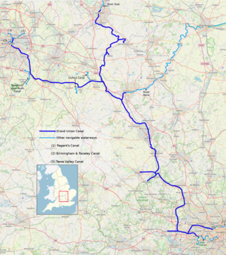
The Grand Union Canal in England is part of the British canal system. It is the principal navigable waterway between London and the Midlands. Starting in London, one arm runs to Leicester and another ends in Birmingham, with the latter stretching for 137 miles (220 km) with 166 locks from London. The Birmingham line has a number of short branches to places including Slough, Aylesbury, Wendover, and Northampton. The Leicester line has two short arms of its own, to Market Harborough and Welford.

<span class="mw-page-title-main">Birmingham and Fazeley Canal</span> Canal in the United Kingdom

The Birmingham and Fazeley Canal is a canal of the Birmingham Canal Navigations in the West Midlands of England. Its purpose was to provide a link between the Coventry Canal and Birmingham and thereby connect Birmingham to London via the Oxford Canal.

<span class="mw-page-title-main">Trent and Mersey Canal</span> Canal in England

The Trent and Mersey Canal is a 93+12-mile (150 km) canal in Derbyshire, Staffordshire and Cheshire in north-central England. It is a "narrow canal" for the vast majority of its length, but at the extremities to the east of Burton upon Trent and north of Middlewich, it is a wide canal.

<span class="mw-page-title-main">Staffordshire and Worcestershire Canal</span> Canal in the West Midlands, England

The Staffordshire and Worcestershire Canal is a navigable narrow canal in Staffordshire and Worcestershire in the English Midlands. It is 46 miles (74 km) long, linking the River Severn at Stourport in Worcestershire with the Trent and Mersey Canal at Haywood Junction by Great Haywood.

<span class="mw-page-title-main">James Brindley</span> English canal engineer

James Brindley was an English engineer. He was born in Tunstead, Derbyshire, and lived much of his life in Leek, Staffordshire, becoming one of the most notable engineers of the 18th Century.

<span class="mw-page-title-main">Tamworth, Staffordshire</span> Town in Staffordshire, England

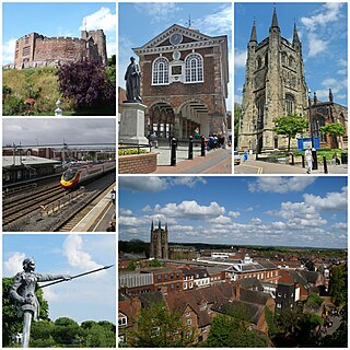
Tamworth is a market town and borough in Staffordshire, England, 14 miles (23 km) north-east of Birmingham. The town borders North Warwickshire to the east and north, Lichfield to the north, south-west and west. The town takes its name from the River Tame, which flows through it. The population of Tamworth borough (2022) was 79,639. The wider urban area had a population of 81,964.

<span class="mw-page-title-main">Oxford Canal</span> Canal in England

The Oxford Canal is a 78-mile (126 km) narrowboat canal in southern central England linking the City of Oxford with the Coventry Canal at Hawkesbury via Banbury and Rugby. Completed in 1790, it connects to the River Thames at Oxford, and links with the Grand Union Canal, which it is combined with for 5 miles (8 km) between to the villages of Braunston and Napton-on-the-Hill.

<span class="mw-page-title-main">Napton on the Hill</span> Human settlement in England

Napton on the Hill is a village and civil parish in the Stratford-on-Avon District of Warwickshire, England. The population of the civil parish taken at the 2021 census was 1,416.

<span class="mw-page-title-main">Birmingham Canal Navigations</span> United Kingdom legislation

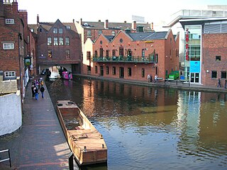
Birmingham Canal Navigations (BCN) is a network of canals connecting Birmingham, Wolverhampton, and the eastern part of the Black Country. The BCN is connected to the rest of the English canal system at several junctions. It was owned and operated by the Birmingham Canal Navigation Company from 1767 to 1948.

<span class="mw-page-title-main">Fradley Junction</span> Canal junction near Lichfield, Staffordshire

Fradley Junction is a canal junction between Fradley and Alrewas near Lichfield, Staffordshire, England and the point at which the Coventry Canal joins the Trent and Mersey Canal. It opened in 1790, and several of the buildings around it, including The Swan public house, are grade II listed structures.

<span class="mw-page-title-main">Warwickshire ring</span>

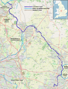
The Warwickshire ring is a connected series of canals forming a circuit around the West Midlands area of England. The ring is formed from the Coventry Canal, the Oxford Canal, the Grand Union Canal, the Stratford-upon-Avon Canal and the Birmingham and Fazeley Canal. It is a popular route with tourists due to its circular route and mixture of urban and rural landscapes.

A canal ring is the name given to a series of canals that make a complete loop.

<span class="mw-page-title-main">Fradley</span> Human settlement in England

Fradley is a village and civil parish, in the Lichfield district, in the county of Staffordshire, England. In 1881 the parish had a population of 380.

<span class="mw-page-title-main">Fazeley Junction</span>

Fazeley Junction is the name of the canal junction where the authorised Birmingham and Fazeley Canal terminates and meets the Coventry Canal at Fazeley, near Tamworth, Staffordshire, England.

<span class="mw-page-title-main">Aston Junction</span>

Aston Junction is the name of the canal junction where the Digbeth Branch Canal terminates and meets the Birmingham and Fazeley Canal near to Aston, Birmingham, England.

The BCN Main Line, or Birmingham Canal Navigations Main Line is the evolving route of the Birmingham Canal between Birmingham and Wolverhampton in England.

<span class="mw-page-title-main">Horseley Fields Junction</span>

Horseley Fields Junction is a canal junction at the western limit of the Wyrley and Essington Canal where it meets the BCN Main Line, at Horseley Fields east of Wolverhampton, in the West Midlands, England.

<span class="mw-page-title-main">Huddlesford Junction</span> Canal junction in Staffordshire, England

Huddlesford Junction is a canal junction at the original north-eastern limit of the Wyrley and Essington Canal where it met the Coventry Canal, near Lichfield, in Staffordshire, England.

<span class="mw-page-title-main">Hawkesbury Junction</span>

Hawkesbury Junction or Sutton Stop is a canal junction in England, at the northern limit of the Oxford Canal where it meets the Coventry Canal, near Hawkesbury Village, Warwickshire, between Bedworth and Coventry. The alternative name, Sutton Stop, arises from the name of a family which provided several lock keepers there in the nineteenth century.

<span class="mw-page-title-main">Fellows Morton & Clayton</span>

Fellows Morton & Clayton Ltd was, for much of the early 20th century, the largest and best-known canal transportation company in England. The company was in existence from 1889 to 1947.
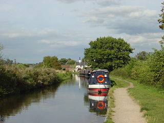
References

  1. "Waterscape - Coventry Canal History". Waterscape.
  2. Waterways Guide 3: Birmingham & the Heart of England. Glasgow: Nicholson. 2009. pp. 56–59. ISBN   978-0-00-728162-6.
  3. "Coventry Canal Basin". BBC. Retrieved 18 August 2018.